At least 24 new volcanic eruptions started since May 1, 2016 worldwide.
But the reason why they all erupt all of a sudden is unexplained! Here a compilation of these new erupting volcanoes.
Bristol Island | South Sandwich Islands (UK) | 59.063°S, 26.587°W | Elevation 1100 m
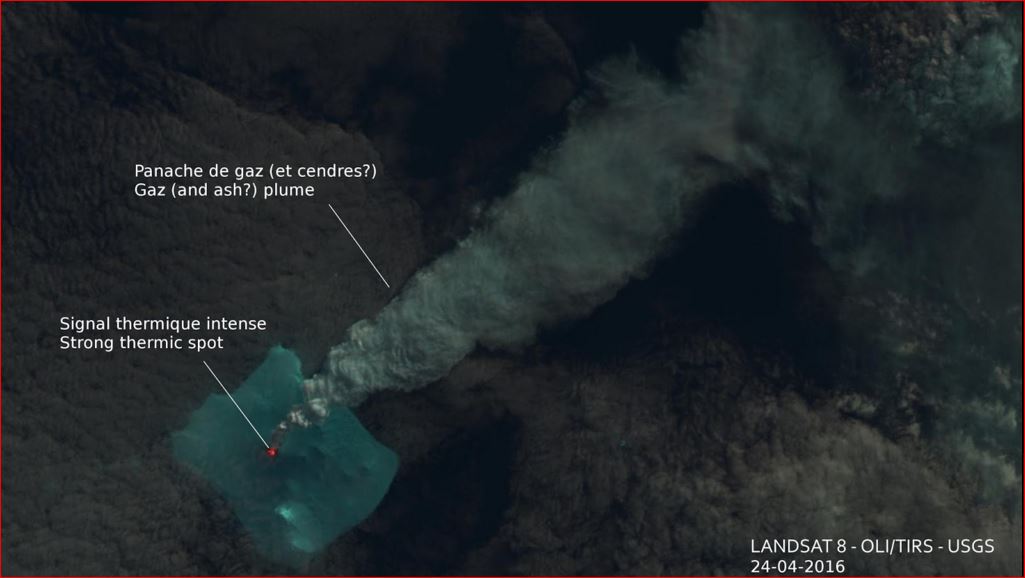
Based on analysis of satellite images, an eruption at Bristol Island likely began on 24 April, the first eruption in 60 years. Landsat images detected a plume and a thermal anomaly in the main crater at the top of Mt. Sourabaya. By 1 May the anomaly was elongated to the W, suggesting that lava had breached the crater rim.
Source: Strange Sounds and Strange Sounds
Nevados de Chillán | Chile | 36.863°S, 71.377°W | Elevation 3212 m
Servicio Nacional de Geología and Minería (SERNAGEOMIN) Observatorio Volcanológico de Los Andes del Sur (OVDAS) reported that the seismic stations monitoring Nevados de Chillán’s Volcán Arrau dome complex recorded an explosion at 1303 on 9 May; an associated plume rose 1.7 km above the crater rim. The Alert Level remained at Yellow, the middle level on a three-color scale, and the public was reminded not to approach the craters within a 2-km radius.
Sources: Strange Sounds, Servicio Nacional de Geología y Minería (SERNAGEOMIN), Oficina Nacional de Emergencia-Ministerio del Interior (ONEMI)
Ruapehu | North Island (New Zealand) | 39.28°S, 175.57°E | Elevation 2797 m
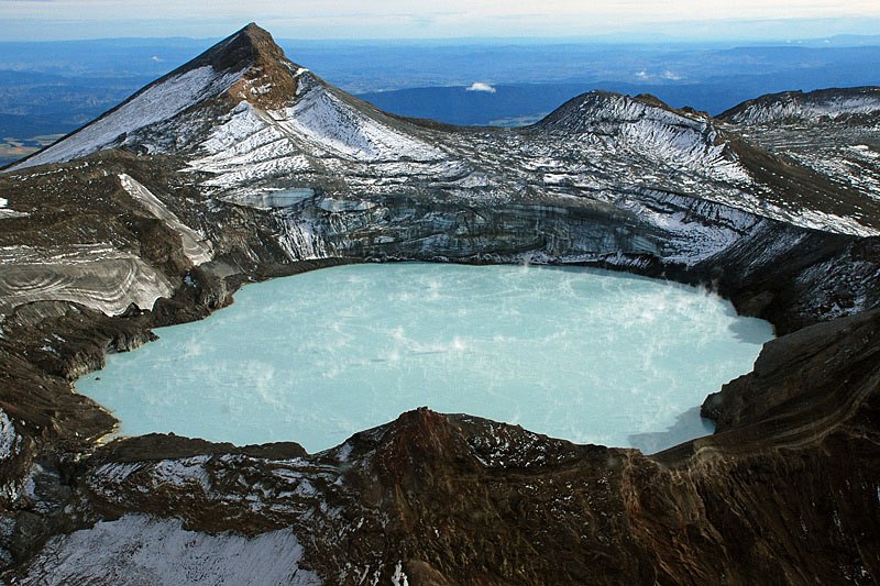
GeoNet reported that a volcanic earthquake swarm beneath Ruapehu’s summit Crater Lake was detected during 25-26 April. This type of swarm has been uncommon at the volcano in recent years, when volcanic tremor has dominated the seismicity. In addition, the crater lake water temperature had been rising since late 2015, from 25 degrees Celsius to 40 degrees in the last half of April. Similar temperature increases were detected in March 2011, April 2014, and February 2015.
In a 3 May notice GeoNet stated that the size and number of events in the swarm had decreased; a period of moderate volcanic tremor began at 1310 on 2 May and lasted about an hour. The lake temperature had peaked at 42 degrees, equal to the highest recorded temperature since 2011. At around 1400 on 7 May tourists on an overflight of the area observed vigorous steaming at the lake surface and upwelling bubbles. The lake temperature rose further, to 44 degrees, establishing a new high since temperatures started to be recorded in 2000. The earthquake swarm had stopped, though the seismic network continued to record volcanic tremor. On 11 May GeoNet stated that recent visits to the lake confirmed increased gas emissions from the crater lake. The lake temperature increased to 46 degrees and moderate levels of volcanic tremor continued. The Volcanic Alert Level was raised to 2 (moderate to heightened unrest) and the Aviation Colour Code was raised to Yellow.
Source: Strange Sounds, GeoNet
White Island | North Island (New Zealand) | 37.52°S, 177.18°E | Elevation 321 m
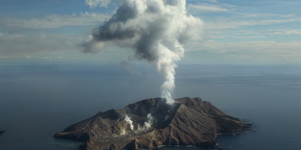
GeoNet reported that activity at White Island decreased following the eruption on 27 April; both volcanic gas output and seismic activity had decreased, and visual observations on 6 May confirmed that no further activity had occurred. The Volcanic Alert Level was lowered to 1 and the Aviation Colour Code remained at Yellow.
Source: Strange Sounds, GeoNet
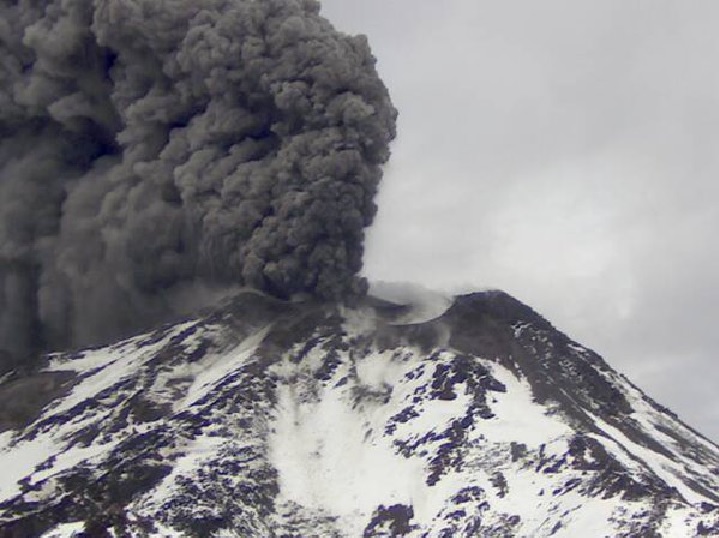
Aira | Kyushu (Japan) | 31.593°N, 130.657°E | Elevation 1117 m
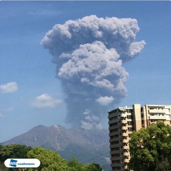
JMA reported that on 8 May explosions from Showa Crater (at Aira Caldera’s Sakurajima volcano) generated an ash plume that rose 3.3 km above the crater rim and ejected tephra as far as 1.3 km from the crater. The Alert Level remained at 3 (on a 5-level scale).
Source: Japan Meteorological Agency (JMA)
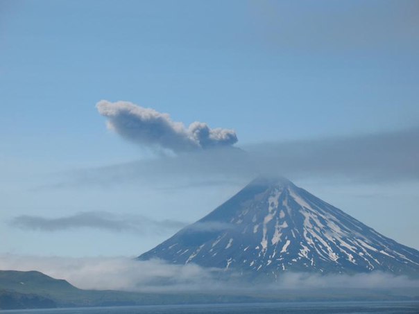
Alaid | Kuril Islands (Russia) | 50.861°N, 155.565°E | Elevation 2285 m
KVERT reported that moderate activity at Alaid continued during 29 April-6 May. Satellite images showed an intense daily thermal anomaly over the volcano. The Aviation Color Code remained at Orange (the second highest level on a four-color scale).
Source: Kamchatkan Volcanic Eruption Response Team (KVERT)
Bagana | Bougainville (Papua New Guinea) | 6.137°S, 155.196°E | Elevation 1855 m
Based on analyses of satellite imagery and model data, the Darwin VAAC reported that during 4-9 May ash plumes from Bagana rose to an altitude of 2.1 km (7,000 ft) a.s.l. and drifted almost 140 km SW and W.
Source: Darwin Volcanic Ash Advisory Centre (VAAC)
Chirpoi | Kuril Islands (Russia) | 46.525°N, 150.875°E | Elevation 742 m
SVERT reported that a thermal anomaly over Snow at Chirpoi volcano was detected in satellite images on 2 and 5 May. The Aviation Color Code remained at Yellow.
Source: Sakhalin Volcanic Eruption Response Team (SVERT)
Cleveland | Chuginadak Island (USA) | 52.825°N, 169.944°W | Elevation 1730 m
AVO reported that an explosion at Cleveland was detected at 1844 on 5 May by both infrasound (air pressure) sensors and seismic data. AVO raised the Level of Concern Color Code to Orange and the Volcano Alert Level to Watch. Satellite views the next day were obscured by clouds; no signs of ash was detected above the cloud deck. AVO noted that the event likely modified the new, small lava dome that had been growing in the summit crater since the previous explosion on 16 April. No activity was observed in satellite images nor detected by the seismic and infrasound networks during 6-8 May. A small explosion was detected at 0732 on 10 May by infrasound sensors. A minor amount of ash was possibly generated by the explosion, but nothing was detected in satellite data and AVO received no reports of ash emissions from local observers or passing pilots.
Source: US Geological Survey Alaska Volcano Observatory (AVO)
Colima | Mexico | 19.514°N, 103.62°W | Elevation 3850 m
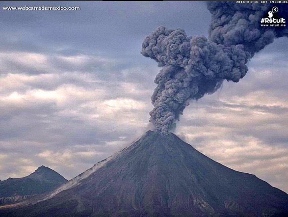
Based on information from Colima Towers and the Mexico City MWO, and webcam and satellite views, the Washington VAAC reported that on 4, 6, and 9-10 May ash plumes from Colima rose to altitudes of 5.2-6.1 km (17,000-20,000 ft) a.s.l. and drifted NW, NE, and E.
Source: Washington Volcanic Ash Advisory Center (VAAC)
Dukono | Halmahera (Indonesia) | 1.693°N, 127.894°E | Elevation 1229 m
Based on analyses of satellite imagery and wind data, and notices from PVMBG, the Darwin VAAC reported that during 4-10 May ash plumes from Dukono rose to an altitude of 2.1 km (7,000 ft) a.s.l. and drifted over 165 km NW, W, and WSW.
Source: Darwin Volcanic Ash Advisory Centre (VAAC)
Fuego | Guatemala | 14.473°N, 90.88°W | Elevation 3763 m
INSIVUMEH reported that during 7-10 May weak-to-moderate explosions at Fuego generated ash plumes that rose 550-750 m above the crater and drifted S, SW, and W.
Source: Instituto Nacional de Sismologia, Vulcanologia, Meteorologia, e Hidrologia (INSIVUMEH)
Kerinci | Indonesia | 1.697°S, 101.264°E | Elevation 3800 m
Based on reports from PVMBG and satellite data, the Darwin VAAC reported that on 4 May an ash plume from Kerinci rose to an altitude of 4.3 km (14,000 ft) a.s.l. and drifted WSW
Source: Darwin Volcanic Ash Advisory Centre (VAAC)
Kilauea | Hawaiian Islands (USA) | 19.421°N, 155.287°W | Elevation 1222 m
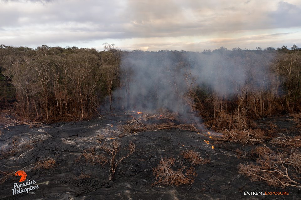
HVO reported that seismicity beneath Kilauea’s summit, upper East Rift Zone, and Southwest Rift Zone was at background levels during 4-10 May. The lava lake continued to circulate and eject spatter in the Overlook vent. Webcams recorded outgassing from multiple spatter cones on the Pu’u ‘O’o Crater floor. A small lava flow from a NE vent intermittently flowed onto the crater floor during 4-5 and 7 May. The June 27th NE-trending lava flow continued to be active within 5.8 km NE of Pu’u ‘O’o Crater.
Source: Strange Sounds, US Geological Survey Hawaiian Volcano Observatory (HVO)
Klyuchevskoy | Central Kamchatka (Russia) | 56.056°N, 160.642°E | Elevation 4754 m
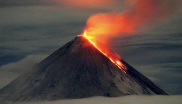
KVERT reported that a Strombolian eruption at Klyuchevskoy continued during 29 April-6 May. Satellite and video data showed a lava flow effusing on the SE flank, down the Apakhonchich drainage. Satellite images showed an intense thermal anomaly over the volcano, and an ash cloud that drifted 88 km SE on 2 May. The Aviation Color Code was raised to Orange.
Source: Strange Sounds, Kamchatkan Volcanic Eruption Response Team (KVERT)
Langila | New Britian (Papua New Guinea) | 5.525°S, 148.42°E | Elevation 1330 m
Based on analyses of satellite imagery and RVO ground observations, the Darwin VAAC reported that during 9-10 May ash plumes from Langila rose to altitudes of 2.1-3 km (7,000-10,000 ft) a.s.l. and drifted 75 km N, NW, and W.
Source: Darwin Volcanic Ash Advisory Centre (VAAC)
Masaya | Nicaragua | 11.984°N, 86.161°W | Elevation 635 m
INETER reported that between 17:00 and 24:00 on 3 May volcanic tremor at Masaya increased; RSAM values spiked at 1,000 units and then dropped to 250. Gas emissions at Santiago crater were at low-to-moderate levels, and the lava lake continued to strongly circulate. On 5 May RSAM values fluctuated between 250 and 500 units, which are low-to-moderate values.
Source: Instituto Nicaragüense de Estudios Territoriales (INETER)
Nevado del Ruiz | Colombia | 4.892°N, 75.324°W | Elevation 5279 m
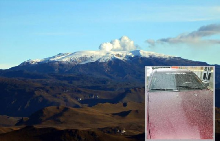
Based on webcam views and information from SGC, the Washington VAAC reported that on 5 May an ash emission from Nevado del Ruiz rose to an altitude of 6.7 km (22,000 ft) a.s.l. and drifted NW.
Source: Strange Sounds, Washington Volcanic Ash Advisory Center (VAAC)
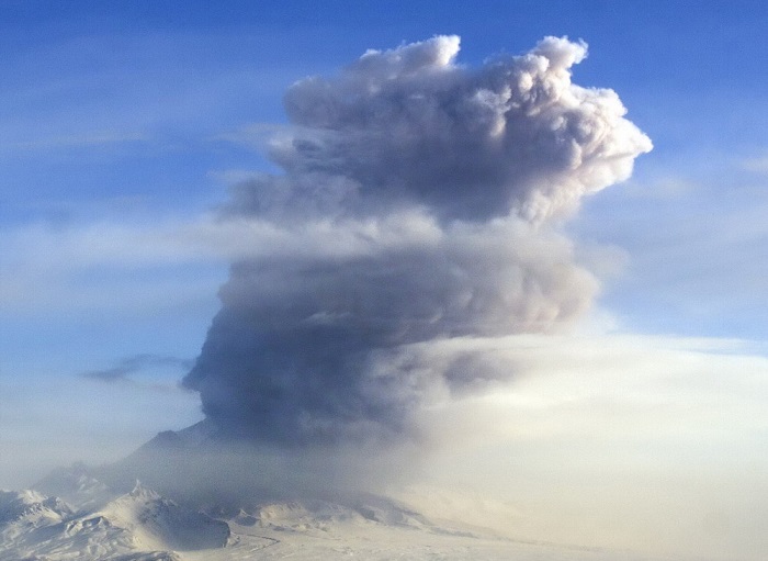
Sangay | Ecuador | 2.005°S, 78.341°W | Elevation 5286 m
Based on satellite images, notices from the Guayaquil MWO, and information from IG, the Washington VAAC reported that during 4-7 and 9-10 May ash plumes from Sangay rose to altitudes of 6.1-8.2 km (20,000-27,000 ft) a.s.l. and drifted as far as 55 km NW, W, WSW, and SW. An intermittent thermal anomaly was identified in satellite images during 4-5 and 10 May.
Source: Washington Volcanic Ash Advisory Center (VAAC)
Sheveluch | Central Kamchatka (Russia) | 56.653°N, 161.36°E | Elevation 3283 m
KVERT reported that during 29 April-6 May lava-dome extrusion onto Sheveluch’s N flank was accompanied by strong fumarolic activity, dome incandescence, ash explosions, and hot avalanches. Satellite images showed an intense daily thermal anomaly over the dome, and ash plumes drifting 36 km SE on 2 May. The Aviation Color Code remained at Orange.
Source: Kamchatkan Volcanic Eruption Response Team (KVERT)
Sinabung | Indonesia | 3.17°N, 98.392°E | Elevation 2460 m
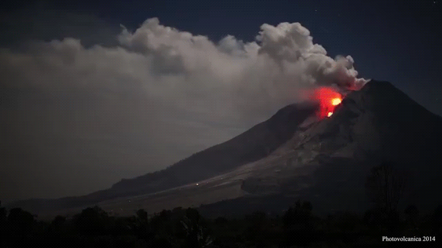
Based on satellite images and information from PVMBG, the Darwin VAAC reported that during 4-5 and 9-10 May ash plumes from Sinabung rose to altitudes of 3.6-4.8 km (12,000-16,000 ft) a.s.l. and drifted W.
Source: Darwin Volcanic Ash Advisory Centre (VAAC)
Suwanosejima | Ryukyu Islands (Japan) | 29.638°N, 129.714°E | Elevation 796 m
Based on JMA notices, the Tokyo VAAC reported that during 4-5 May explosions at Suwanosejima generated ash plume that rose to altitudes of 1.5-2.1 km (5,000-7,000 ft) a.s.l. and drifted SE.
Source: Tokyo Volcanic Ash Advisory Center (VAAC)
Turrialba | Costa Rica | 10.025°N, 83.767°W | Elevation 3340 m
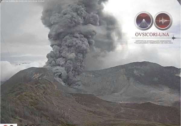
OVSICORI-UNA reported that frequent small explosions and sustained tremor with significant and variable amplitude continued to be recorded at Turrialba during 3-5 May. Ash plumes rose 500 m above West Crater and drifted NW and SE, though larger explosions generated ash plumes that rose as high as 1 km. During 6-7 May gas-and-water-vapor plumes rose 1 km. Tremor was characterized as having short duration and a moderate amplitude; for a period between 05:30 and 17:00 on 7 May tremor amplitude was high but then afterwards it drastically decreased and a significant number of discrete volcanic earthquakes were recorded. Small lahars descended drainages on the upper flanks, mainly in the Río Aquiares drainage. During 02:00-09:00 on 8 May small, frequent ash emissions, that rose no more than 500 m, were observed coincident with the detection of spasmodic tremor. Gas emissions rose 500 m above the crater at least until noon on 10 May. The amplitude of the volcanic tremor decreased and remained low.
Source: Strange Sounds, Observatorio Vulcanologico y Sismologico de Costa Rica-Universidad Nacional (OVSICORI-UNA)
The worldwide volcanic unrest is continuing around the world and nobody knows why!


