California is known for earthquakes…
But did you know we are also home to 8 high-risk volcanoes and more than 500 volcanic vents? What is the likelihood of a volcano erupting in California? Here a small talk to the people monitoring California’s volcanoes.
And here a map of volcanoes in California:
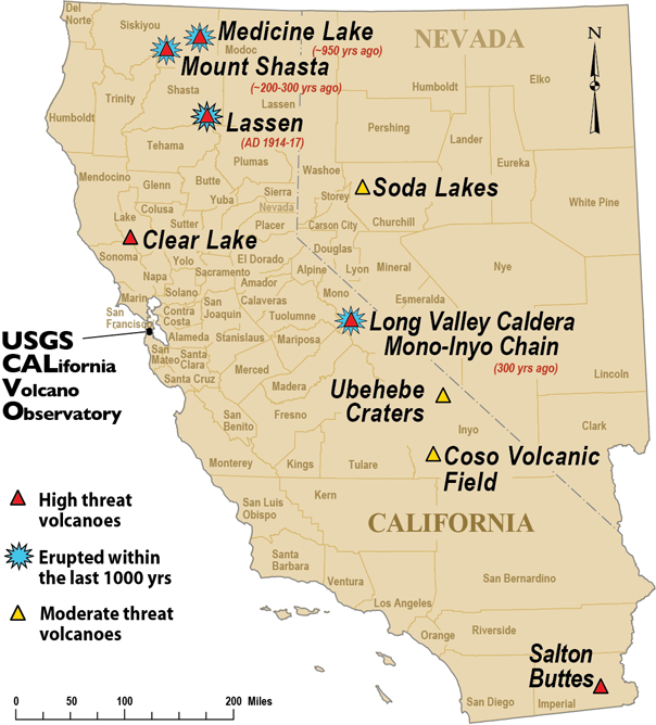
The national report on volcanic threat published by the USGS in 2005 ranks the youngest and potentially dangerous centers in California and Nevada as:
Very High Threat Potential
Lassen Volcanic Center (Shasta County)
Long Valley Caldera (Mono County)
Mount Shasta (Siskiyou County)
High Threat Potential
Clear Lake Volcanic Field (Lake County)
Medicine Lake (Siskiyou & Modoc Counties)
Mono-Inyo Chain (Mono County)
Salton Buttes (Imperial County)
Moderate Threat Potential
Coso Volcanic Field (Inyo County)
Soda Lakes (Nevada, Churchill County)
Ubehebe Craters (Inyo County)
Very Low Threat Potential
Brushy Butte (Shasta County)
Eagle Lake Volcanic Field (Lassen County)
Golden Trout Creek Volcanic Field (Tulare County)
Lavic Lake Volcanic Field (San Bernardino County)
Silver Lake Volcanic Field (Shasta County)
Tumble Buttes (Shasta County)
Twin Buttes (Shasta County)


