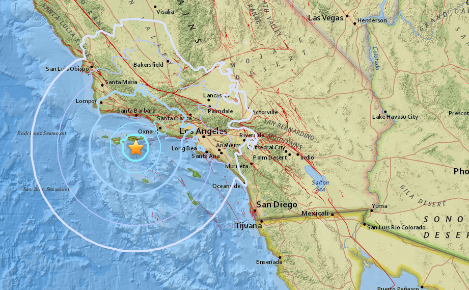
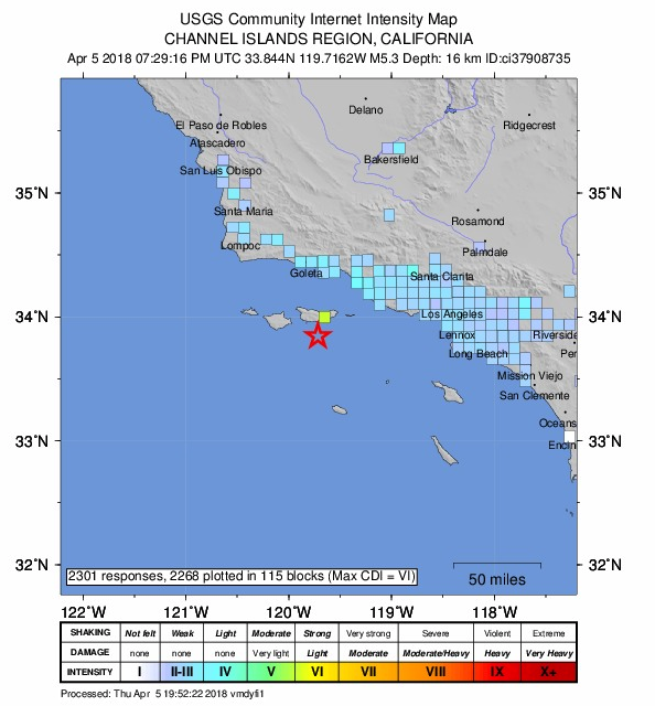
An earthquake with an upgraded magnitude of 5.3 struck 38 miles south west of Ventura in the Channel Islands area about 12:30 p.m. Shaking was felt all along the coast, from the San Luis Obispo area to the north to San Clemente in the south. More than 10,000 people reported feeling the quake on the USGS homepage. The National Weather Service also said there was no tsunami danger as a result of the tremor.
Shaking was felt in the Los Angeles area early Thursday afternoon as an earthquake with preliminary magnitude of 5.3 struck off the coast in the Channel Islands.
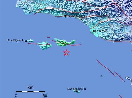
The temblor hit beneath the Pacific Ocean about 12:29 p.m., at a depth of about 10 miles beneath the surface, USGS reported. It was centered about 41 miles southwest of Ventura and 85 miles west of Los Angeles.
The Los Angeles Fire Department is in “earthquake mode” following the shaking, as is standard protocol.
There were no immediate reports of injuries or damage, according to law enforcement and fire agencies across Southern California.
Shaking was felt all along the coast, from the San Luis Obispo area to the north to San Clemente in the south, USGS reported.
On social media, people across the Southern California region reported feeling the quake, with many describing it as “rolling.”
One woman said the quake’s “rolling motion” caused walls to creak and items to swing in Torrance. Others described feeling the temblor from as far away as San Jacinto and central Orange County.
The National Weather Service also said there was no tsunami danger as a result of the tremor.
Seismologist Lucy Jones, formerly of the USGS, described it as a “moderate”-size earthquake. She said a quake this large hasn’t occurred in the region in several years, a period she called “quiet.”
“It’s a regular sort of earthquake that we expect somewhere in Southern California,” Jones said. “Magnitude 5.3 is a size that happens on average about once a year in Southern California.”
The 2014 La Habra quake is the most recent temblor of this size, she said. That quake was a 5.1. For perspective, the 1994 Northridge quake would have had 50 to 60 times as much energy.
The Ventura County Fire Department reminded residents that earthquakes — “even smaller ones” — are good reminders for everyone to prepare.
Ventura County Fire Department Capt. Steve Swindle told KTLA he was at the agency’s headquarters in Camarillo when the earthquake hit and he felt it.
He said that during a tremor, officials at stations countywide put out their apparatuses and fire engines so they can be prepared to respond in the event of an aftershock.
Swindle added that crews drove around to assess possible damage Thursday afternoon.
“So far, thankfully, there hasn’t been any damage reported out of this,” he said.
He advised residents of Ventura County to visit VCreadysetgo.org and be prepared for other incidents.
“It is Southern California, we are earthquake country. We know that it’s coming,” Swindle said. “Being prepared is always your best bet to help yourself.”
So did you catch it? Get prepared for the next Big One!!


 elevation within seconds!")


")

")
[…] Shallow M5.3 earthquake strikes off the Channel Islands in California – Earthquake is felt across … […]
[…] Shallow M5.3 earthquake strikes off the Channel Islands in California – Earthquake is felt acr… […]
[…] Shallow M5.3 earthquake strikes off the Channel Islands in California – Earthquake is felt acr… […]
This is the big tremor of the cleaning up operation of Galactic Federation of Light. The target is the reptilian secret undersea bases just south of Channel Islands National Park. As I have mentioned several times, all national parks are the surface facilities of the secret underground or undersea bases. Yes, state or national parks are all military infrastructures. Have you seen what kind of weapons all the park rangers have? They wear more weapons than a city police. Especially Channel Islands National Park have many undersea caves. I have mentioned that all the cave system are part of their secret bases. On some island, they have even military bases, and they do joint exercise with military of many countries.
Around there, there are many secret undersea bases just beside Point Megu Naval Station. They have also the entrance toward underground aquifer passages toward Naval Undersea Warfare Center in Hawthorne, Nevada.
Youtube: Naval Undersea Warfare Center Aqua Channels to Pacific Ocean Conspiracy Hawthorne, NV
one 9.0 quake kills 100k send sodom back to the 1700! repent , ask Jesus to save you!
[…] article source […]