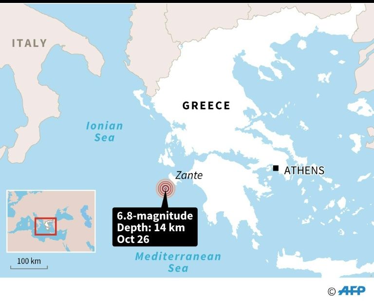
A magnitude 6.8 earthquake struck in the Ionian Sea off the coast of Greece early Friday, briefly triggering a tsunami warning. No significant damage has been reported. The quake hit at a shallow depth of 16.6km (10 miles) below the sea floor. It reached the island of Zakynthos, a popular tourist destination, with first reports indicating that some of the buildings there have sustained damage.
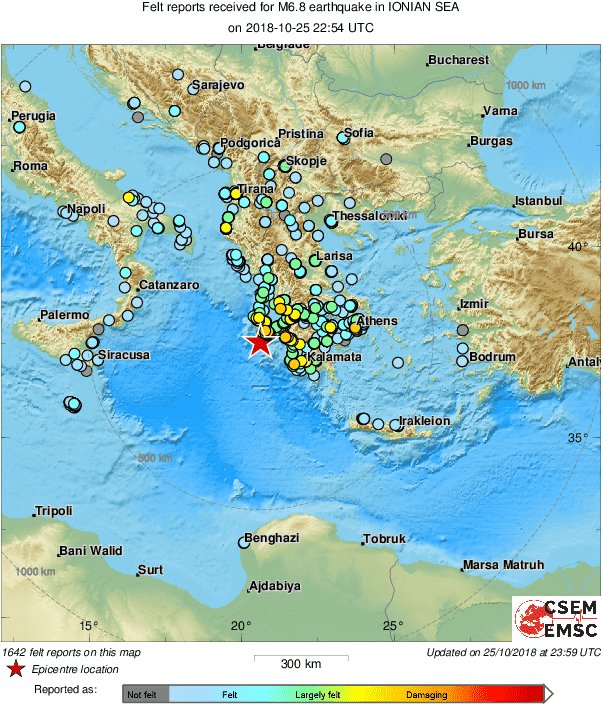
The quake was so powerful the jolts were felt across the region in at least eight countries, including Malta, Libya, Italy, Macedonia, Albania, Bosnia, Bulgaria and Turkey:
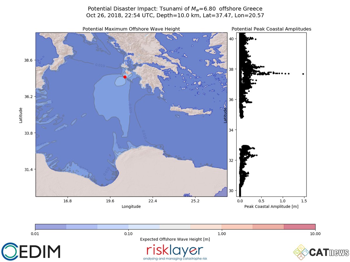
The European-Mediterranean Seismological Centre (EMSC) warned about a possible low-scale tsunami that could last for several hours after the earthquake, citing sea level changes following the tremor.
and here the gauge:
⚠️A tide gauge located 70 KM from the epicenter (in #Katakolo, #Greece) of the #earthquake, is recording the #tsunami waves, is ordered to evacuate immediately within a radius of 300 KM around the epicenter of the earthquake, do not go near the beach.#EQVT. pic.twitter.com/HGlN3Tkxj3
— American Earthquakes (@earthquakevt) 26 octobre 2018
Locals were advised against going to the beach to try and observe the tsunami. On Twitter, the EMSC cautioned that while in most places the wave will likely be limited to 20cm (about 7in) high, it could be significantly bigger locally.
Sea level changes observed in Greece confirming TSUNAMI pic.twitter.com/uoNS39L6eU
— EMSC (@LastQuake) October 25, 2018
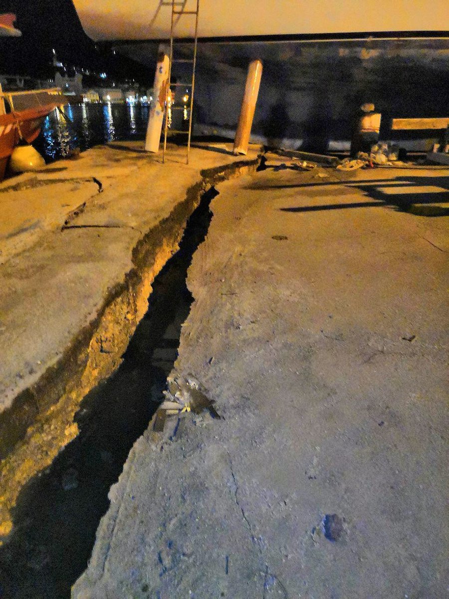
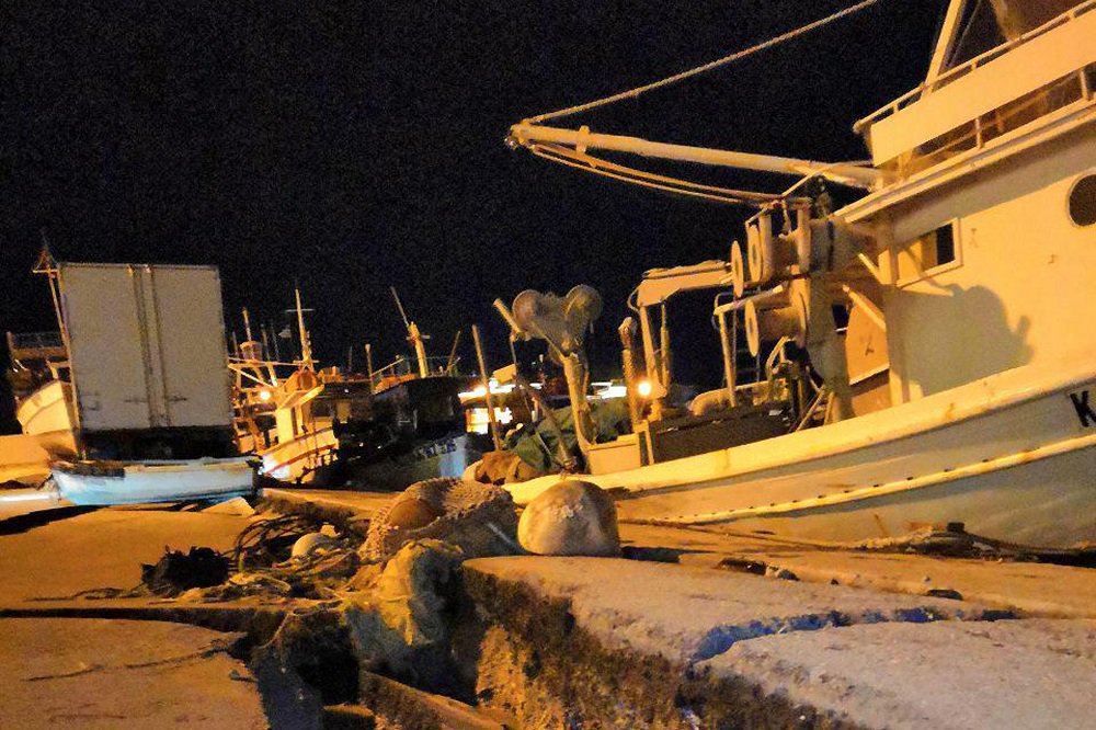
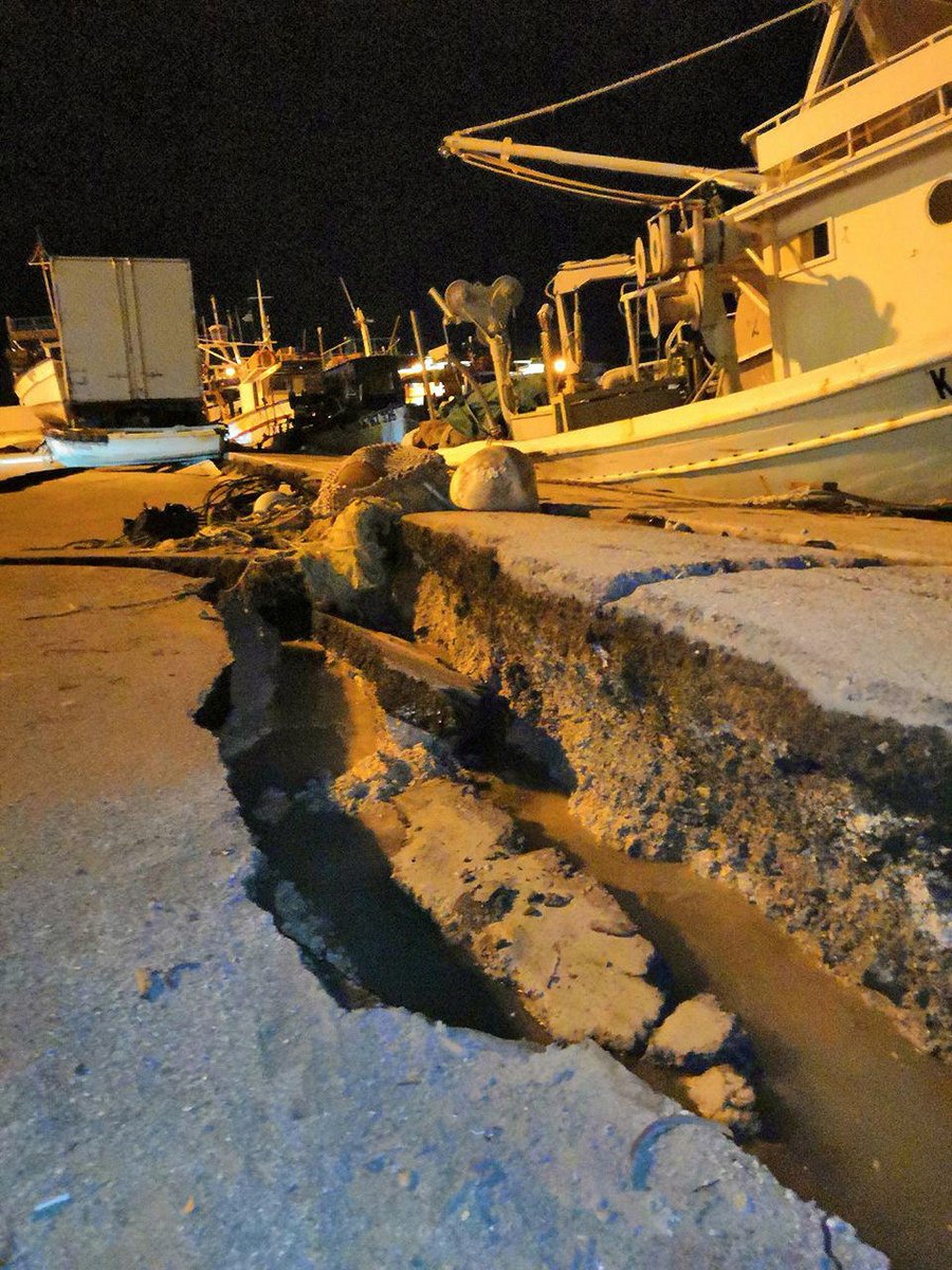
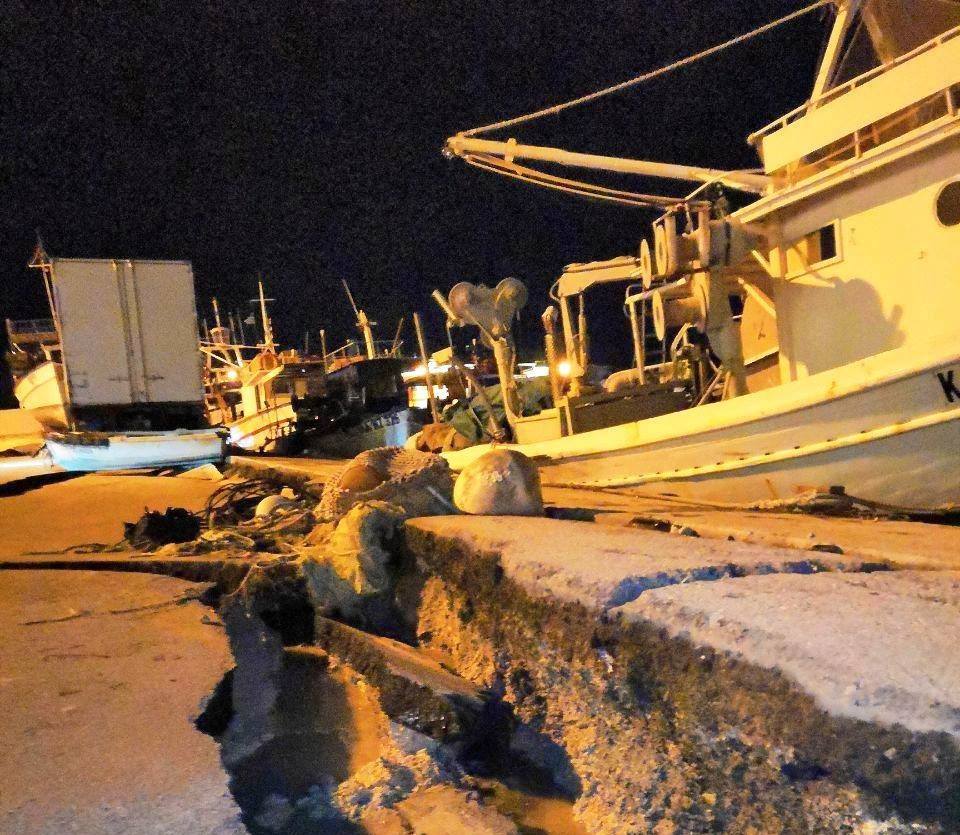
The 6.8 magnitude earthquake in Greece left cracked concrete in the tourist island of Zakynthos. Power has been cut off, but no major injuries were immediately reported.
Here a few videos captured in living rooms in Patras, Greece:
Lamps swaying in Patras, Greece under the effects of the magnitude 6.6-6.8 earthquake tonight (22:54 UTC, Oct 25). Report: Theodoris Livanos pic.twitter.com/0flpgwJEW5
— severe-weather.EU (@severeweatherEU) 25 octobre 2018
and somewhere else in western Greece:
Anybody else in western Greece feel that massive earthquake about 20 minutes ago? This is video of our dining room chandelier stroll swinging 1-2 minutes *after* the earthquake ended! #earthquake #Patra #westernGreece #expatlife pic.twitter.com/4mDC2FUulO
— Aliz Koletas (@AlizKoletas) 25 octobre 2018
At least fifteen aftershocks have been reported in the wake of the quake.
Follow us: Facebook and Twitter or become a Patron on Patreon / donate through Paypal. Please and thank you.
USGS – M6.8 – 33km SW of Mouzaki, Greece
Tages Anzeiger – Starkes Seebeben erschüttert Griechenland


END TIMES SIGNS LATEST STRANGE EVENTS (OCT 25, 2018) THIS HAPPENED ON OUR EARTH | EXTREME WEATHER
https://www.youtube.com/watch?v=Qf7v-YtTL4E
The beginning of the video, it looked like the land was draining out to sea? It looked wired. Still I cannot find the extent of the damage to Guam and Saipan caused by Hurricane Yutu. I am sure that Government does not want people to know the damage, any damage of disasters in US. Government does not want people to realize something is going on this world.
Flash Floods Near The Dead Sea Swept Away A School Group Visiting Hot Springs, Killing 19 | TIME
https://www.youtube.com/watch?v=EZqyQxALRBU
Jordan Horrific floods: Heavy storm unexpected huge rainfalls caused a flash flood in Jordan
https://www.youtube.com/watch?v=fbIL1pabsOk
The hot springs resort those flash flood victims (with Karma) wanted to reach
Mujadara – Jordanian Comfort Food at Ma’in Hot Springs
https://www.youtube.com/watch?v=Xg7cU4-4u1A
“Emergency Mode” of The Pantex Nuclear Weapons Plant Re-Cap
About 6:46PM, Amarillo Texas got M4.0 (USGS might down graded) rare tremor. There has not been any earthquake around Amarillo as long as I have been checking USGS site for years. The epicenter coordinates are 35.361°N 101.793°W. This coordinates might be also lied by USGS, but this epicenter was very close to Pantex Nuclear Weapons Plant.
Dutchsinse reported on his Youtube video saying he saw “a strong cell” suddenly started appearing in the CLEAR SKY in a radar just HOURS BEFORE this M4.0 tremor happened. This is really strange “A strong cell started appearing in the CLEAR SKY.” This strong cell should be a mother ship of Galactic Federation of Light.
Then less than 3 days later, Pantex Nuclear Weapon facility decleared “Emergency”. Since the M4.0 tremor happend, it had been 3 days, some kind of radiation contamination or plutonium might had been escaped from the facility, contaminating not only around Amarillo Texas, but also Oklahoma, Kansas and beyond. What if the tremor had been caused by the explosion in their secret underground bases under Pantex (It is possible that USGS lies the location of epicenter if they lie and down grade the strength of many tremors.)
Hey, connect all the dots. Just in last few days or a week, Trump had announced he will withdraw from the Nuclear Arms Treaty on Oct 20 that was the day Amarillo M4.0 tremor happened. Pence announced that US Government will use nuclear weapons in space. Do you remember their plan to make “Space Force”? (in order to fight against Galactic Federation of Light in space.)
The Pantex Nuclear Weapons Plant Freaked Everyone Out By Announcing A Vague ‘Operational Emergency’ With Zero Details
https://taskandpurpose.com/pantex-plant-nuclear-emergency/
It is obvious a huge Reptilian Secret Undersea complex has been demolished with some explosions. As usual, the area on Google Map had been blurred by their entities. But it looks there are huge secret undersea facilities around there. Galactic Federation of Light attacked and demolished those Reptilian Undersea Bases with many explosions that caused those tremors.
If we look at USGS earthquake map, a swarm of tremors (I counted to 28.) occurred. All depths of tremors are 10.0 km just! (except for the biggest tremor with depth of 14 km.). The depth of 10.0 km just is the signature of attacks from Galactic Federation of Light.
On Google Map, look at the nearest island of the epicenters. There are many quarries (=entrances and construction sites of Reptilian Secret Underground Bases) and so many caves (=parts of Reptilian Underground Base). With beautiful beaches and water (Of course, do not forget their secret undersea bases.), I am sure that those Reptilians are enjoying life like a king. They have unlimited money. They can create money out of thin air, just like adding any digits on their bank account. They have the agreement with Government in any country. Remember “money” has been created by Reptilian entities in order to make us their slaves.