The U.S. Geological Survey said Friday that an ongoing earthquake swarm that began at 5:52 p.m. Thursday is centered beneath Yellowstone Lake. There have been 40 earthquakes bigger than a magnitude 2, and two have been above a 3.0 magnitude, USGS said.
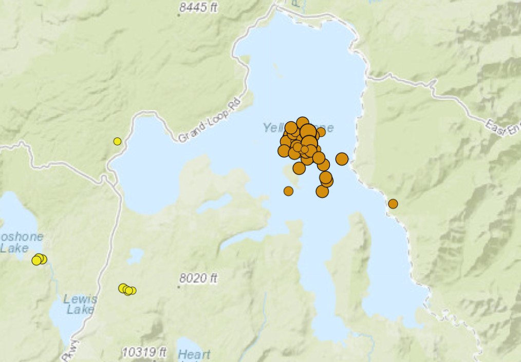
In the past day, there have been 10 earthquakes with a 2.5 magnitude or greater, according to USGS. The largest was a 3.1-magnitude quake that shook beneath Yellowstone Lake at 8:12 a.m. Mountain Time.
The new earthquake swarm is nothing to worry about but reminds you that the most dangerous Yellowstone’s threat isn’t a volcanic supereruption but a powerful and devastating jolt.
What are Yellowstone’s threats?
Yellowstone offers a dual threat to the public including the threat of a large earthquake with the additional threat of volcanic activity.
Yellowstone’s earthquake threat

Yellowstone has experienced the largest historical earthquake in the Intermountain West in the 1959 MW7.3 Hebgen Lake earthquake.
This event occurred on August 17, 1959 just west of Yellowstone National Park in the Madison Canyon.
The earthquake ruptured the Hebgen Lake and Red Canyon faults and produced fault scarps as high as 6.7 m (22 ft).
In total, 28 people died in the earthquake, 19 of those were permanently buried beneath the Madison Canyon Landslide, which was triggered above the Rock Creek Campground by the intense shaking.
Rocks and landslides tumbled into Yellowstone National Park highways in several places, blocking roads between Old Faithful and Mammoth closing the route to the park’s west entrance at West Yellowstone, Montana.
In addition, there was damage to numerous buildings throughout the park including the historic Old Faithful Inn where the indoor chimney collapsed into the dining room.

On average, The University of Utah seismograph stations locates ~1,500 – 2,000 earthquakes per year in the Yellowstone region. The majority of these events are too small to be felt by residents and visitors to the region.
Yellowstone’s volcanic threat

There have been three major caldera-forming eruptions in the Yellowstone region in the last 2.1 million years.
- The first of three major eruptions in the Yellowstone area occurred 2.1 million years ago and erupted 2,500 km3 (600 mi3) of material depositing the Lava Creek Tuff.
- There was a second major eruption in Yellowstone 1.3 million years ago with 280 km3 (67 mi3) of material erupted forming the Mesa Falls Tuff.
- The last major eruption of the Yellowstone volcano occurred 640,000 years ago erupting 1,000 km3 (240 mi3) of material depositing the Huckleberry Ridge Tuff and forming the Yellowstone caldera.
Since the last major eruption of the Yellowstone volcano, there have been numerous smaller eruptions that have emitted rhyolite lava that has subsequently filled in most of the Yellowstone caldera. The youngest of these flows is the Pitchstone Plateau flow that occurred 70,000 years ago.
Hydrothermal explosions
In addition to volcanic eruptions, there are other volcano related threats in Yellowstone including hydrothermal explosions. Yellowstone has a history of some of the worlds largest hydrothermal explosions.
Large hydrothermal explosions (>100 m [~330 ft] in diameter) in Yellowstone have occurred over the past 16,000 years averaging ~1 every 700 years; similar events are likely in the future. These events pose a risk to park visitors and structures.
Earthquake bigger risk than supervolcano eruption
The earthquake swarm is nothing to worry about, geologists said.
“Earthquake sequences like these are common and account for roughly 50% of the total seismicity in the Yellowstone region,” USGS said on Twitter. “This swarm is similar to one that occurred in about the same place during December 2020.”
Some people, however, still worry earthquakes in Yellowstone are a sign that the “supervolcano” that lies beneath the park will soon erupt, which could have regional and global consequences.
“Such a giant eruption would have regional effects such as falling ash and short-term (years to decades) changes to global climate,” USGS said on its website. “Those parts of the surrounding states of Montana, Idaho, and Wyoming that are closest to Yellowstone would be affected by pyroclastic flows, while other places in the United States would be impacted by falling ash (the amount of ash would decrease with distance from the eruption site).”
The USGS doesn’t think an eruption at Yellowstone is likely for thousands of years. Even with the current swarm, the alert level at the Yellowstone Volcano Observatory is green, which is normal.
What causes swarm at Yellowstone?
Earthquake swarms are common at Yellowstone and many other places.
Swarms occur in a variety of volcanic and tectonic settings and have several possible causes.
- Some swarms are driven by slow fault slip that causes earthquakes on a few sticky patches of the fault.
- Other swarms are generated when magma-filled cracks push their way through the crust.
- And perhaps most commonly, swarms can be generated when aqueous fluids (water) enter and interact with pre-existing faults in the crust.
- Sometimes, combinations of these mechanisms might be active in a given swarm.
But how can we distinguish among these processes?
At a volcano, everyone wants to know, “is the swarm driven by magma?” This question is particularly pressing if the swarm is occurring at shallow depths (within a couple miles of the surface). A shallow, magmatically driven swarm could potentially be a precursor to an eruption.
A primary distinction between magma and water as a driving mechanism is the width of the crack required for the fluid to move through the crust. While water can travel through very small preexisting cracks or faults within the crust, magma requires a much thicker crack to allow the magma to continue to propagate without quickly cooling and solidifying.
Seismic observation
We can potentially observe several properties of the seismicity related to this difference in crack widths. For example, earthquakes triggered by water will usually occur as fault slip on the crack(s)/fault(s) along which the fluids are propagating. That is, the two sides of the crack hosting the fluids are still in contact with each other, but the fluid reduces the clamping forces and lubricates the fault enough to allow it to slip.
In contrast, the walls of a crack hosting magma are generally not in direct contact with each other — they are separated by the magma itself. So rather than occurring by a slip between the walls of the crack, earthquakes will instead occur near the crack tip (the point ahead of the magma where the crack is starting to open) or off to the sides of the crack (because the opening of the crack stresses the surrounding rock).
In the case where a swarm is caused by slow fault slip, earthquakes repeatedly occur on the same small sticky patches within a dominantly creeping fault. There might be no progression of seismicity at all — just the same small patches constantly generating earthquakes.
Deformation
In addition to seismic observations and the pattern of earthquake locations, we can also use deformation measurements to examine changes in the shape of the surface above the earthquake swarm.
The opening of thick cracks required for magma propagation creates a warping of the earth’s surface, which becomes increasingly large and easy to observe for the shallow cracks that would be of most concern.
Swarms driven by aqueous fluids pressurizing preexisting cracks, in contrast, would cause only very small surface warping, mostly due to slip in the cracks themselves, and is usually too small to be observed.
Slow fault slip, if large and shallow enough, can be observed on the surface, but the pattern of deformation is very distinct from that caused by a magma-filled crack and therefore easy to distinguish.
Geological context
When interpreting the process(es) that might be causing an earthquake swarm, it is also important to consider the context.
At Yellowstone, for example, the last magmatic eruption was a lava flow that occurred about 70,000 years ago, but the area is home to one of the most vigorous hydrothermal systems on Earth.
So even though eruptions are rare, we observe many small earthquake swarms at Yellowstone every year, and relatively large earthquake swarms every few years.
The characteristics of the swarms, and their context, indicate that the vast majority are driven by water moving through the subsurface.
Example: the June-September 2017 Maple Creek swarm
As an example of putting this all together, let’s consider the June-September 2017 Maple Creek swarm — the second-largest earthquake swarm ever recorded in Yellowstone.
About 2,400 earthquakes, the largest of which was M4.4, were located over about three months in the northwest part of Yellowstone National Park, between Norris Geyser Basin and Hebgen Lake.
The earthquakes moved around over time but were occurring in an area that hosts numerous existing faults. The migration of the seismicity was rapid, and no ground deformation occurred.
Observations like these suggest that water was the cause of the swarm. Water was also the most likely cause of an intense swarm that occurred near Madison Junction, in the western part of Yellowstone, in 2010.
Example: 2008-2009 Yellowstone Lake swarm
A more complex case was the 2008-2009 Yellowstone Lake swarm. Rapid migration of earthquakes in this swarm suggest it might have been driven by a low-viscosity fluid (such as water or CO2) that could move easily through small cracks in the subsurface.
But unlike other recent swarms in the park, this swarm was accompanied by a small amount of observed surface deformation, making it difficult to completely rule out a magmatic source.
To determine the cause of the current swarm in Yellowstone Lake, we will first need a more detailed analysis of the freshly gathered data. But don’t be too frightened… The supervolcano is not about to erupt! [Bakersfield, USGS, Wyofile]
Now subscribe to this blog to get more amazing news curated just for you right in your inbox on a daily basis (here an example of our new newsletter).
You can also follow us on Facebook and/ or Twitter. And, by the way you can also make a donation through Paypal. Thank you!
You should really subscribe to QFiles. You will get very interesting information about strange events around the world.


Yet we have marxist-billionaires moving out to Montana, Wyoming, and Idaho —buying swaths of land.
Same can be said for the Marxist-billionaires claiming global warming/rising sea levels are a major (FAKE) threat, yet they buy up properties along the beach.
Yellowstone is awesome. I recommend visiting and enjoying the beauty.
https://humansarefree.com/2021/07/cdc-12000-deaths-in-7-months-following-covid-19-vaccines.html
Here’s an interesting read. All marxists, please get your vax, and booster jabs.
https://humansarefree.com/2021/07/mrna-inventor-most-vaccinated-countries-are-experiencing-surge-in-covid-19-cases.html
Ha, eye-opener. Looks like the sheeple are living up to their name. Keep up vaxing yourselves you vaxtards.
The only upside to the vax is that two-digit I.Q. folks won’t be breeding much. So, we can look forward to a world less encumbered by useless idiots.