A strong earthquake swarm started under the area of La Cumbre Vieja volcano in the southern part of La Palma Island this weekend. It is still undergoing right now.
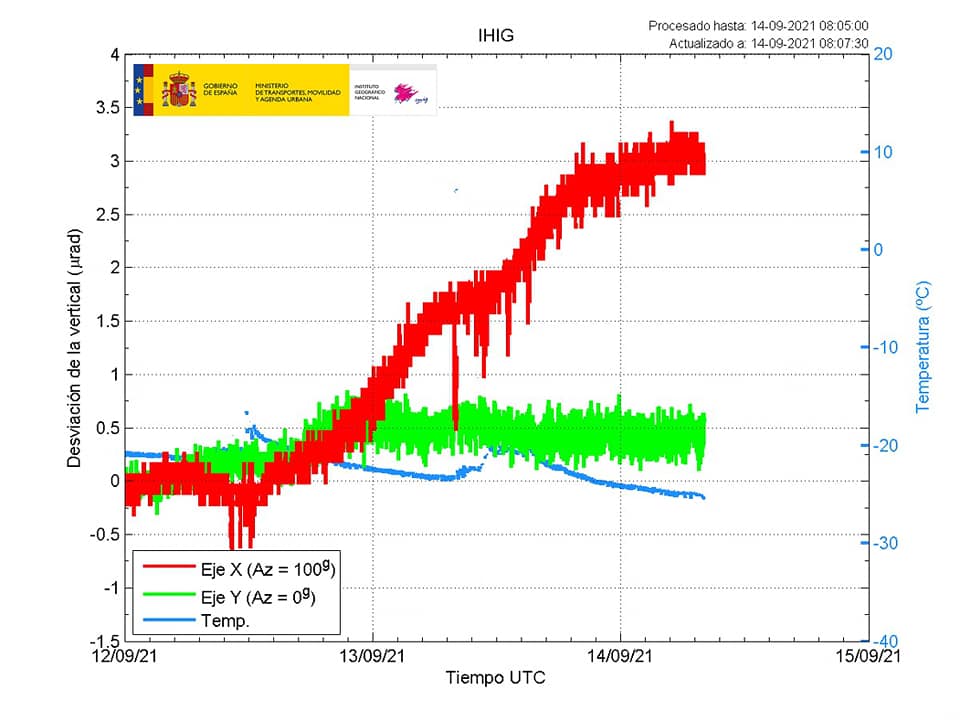
As of September 14, 2021, the seismic activity appears to be moving westward and its depth has decreased. Scientists have detected an upwelling (surface deformation) of about 1.5 cm at the swarm location.
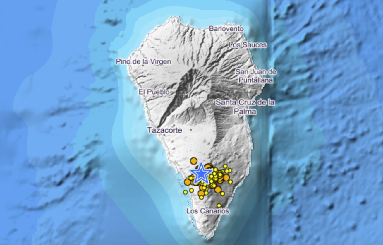
Since the beginning of the seismic swarm – Sept. 11th at 3:18 (UTC) – more than 2935 quakes have been detected in the southern area of the island of La Palma, including 25 quakes of magnitudes above 3.0.
The largest earthquake (M3.9) occurred today, September 14, 2021 at 06:00 (UTC) and has been reported and felt by the nearby population.
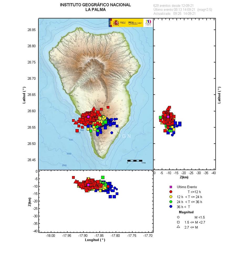
The earthquake depth ranges between 8 and 10 km below the volcano, suggesting that new magma is currently intruding into a reservoir under the volcano.
In the last hours, the seismicity apparently is slightly migrating westwards.
Meanwhile, the IGN has intensified the monitoring of the seismic and volcanic activity on La Palma.
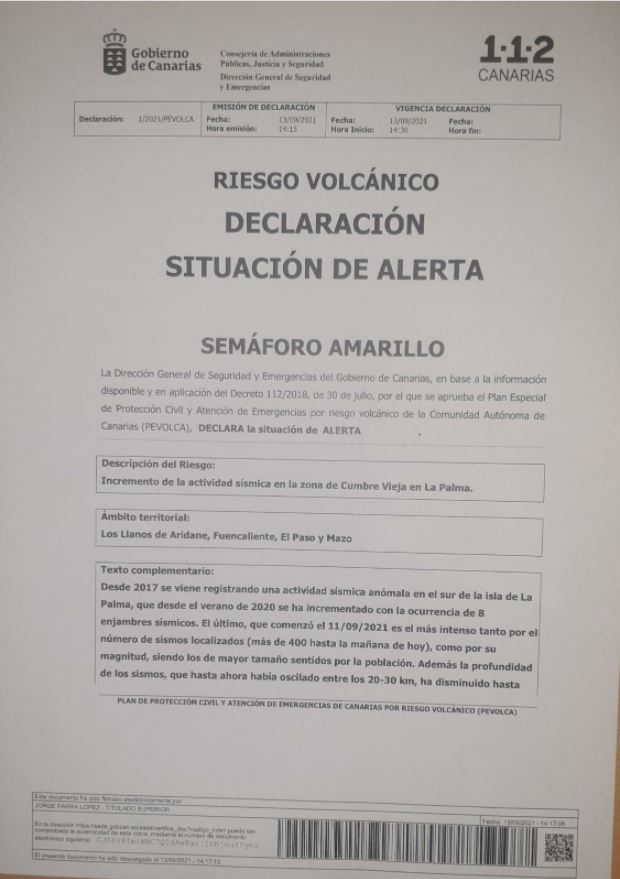
Yesterday, officials issued the Yellow alert for has been issued for La Palma volcano:
It is still hard to say whether or not this enhanced seismic activity and slight ground deformation will lead to a volcanic eruption.
Seismographs and going frenzy on La Palma:
Ojo al sismograma de #LaPalma. Puedes seguirlos en la web del @IGNSpainhttps://t.co/MZXt56jXf0 pic.twitter.com/KznKSgeAvD
— Itahiza (@ita_dc) September 12, 2021
Similar earthquake swarms have occurred in the past as well, most recently in late December last year. However, during that event, the quakes were deeper (at around 30 km depth).
Has magma now risen higher in the volcano’s underground storage systems?
La Cumbre Vieja volcano last erupted in 1971, and it is considered one of the most active volcanoes of the Canary Islands.
La Palma Mega tsunami
Cumbre Vieja volcano lies on the southern third of La Palma,Canary Islands, and rises about 2 kilometers (1.2 mi) above sea level and 6 kilometers (3.7 mi) above the seafloor.
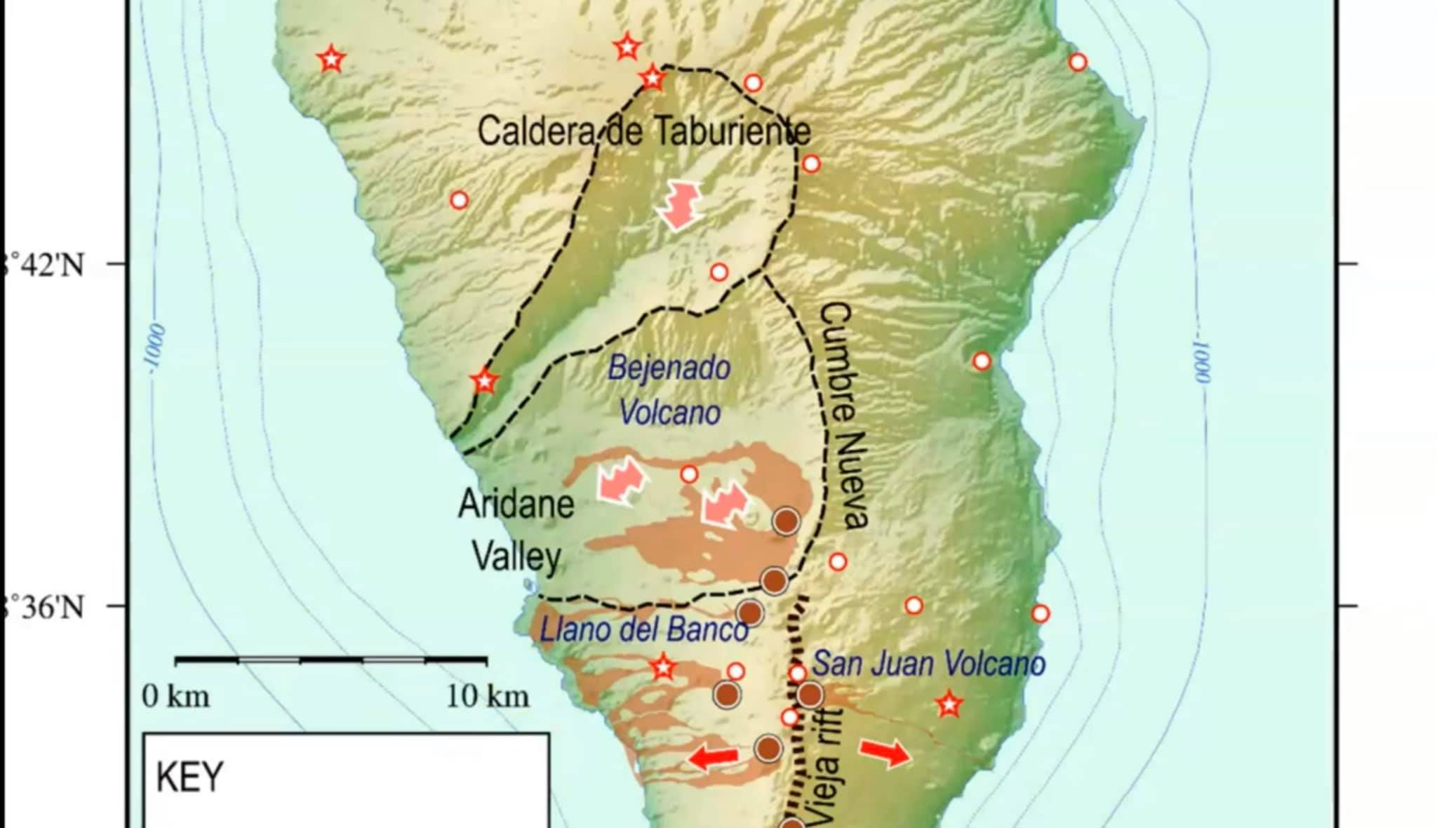
It is the fastest growing volcano in the archipelago and thus dangerous in terms of collapses and landslides.
Professor Stephen Sparks, one of the world’s most reputable volcanologists, said, “When volcanic islands emerge from the sea, they are very unstable. And, in some cases, huge landslides can happen when part of the island collapses into the sea…”
Several collapses took place since the Pliocene, followed by the growth of Cumbre Vieja during the last 125,000 years. The last eruption of La Palma was in 1971, the most recent subaerial eruption in the Canary Islands.
What effects would a collapse of Cumbre Vieja have?
One of the multiple scenario by Steven N. Ward and Simon Day proposes that a Holocene change in the eruptive activity of Cumbre Vieja volcano and a fracture on the volcano that formed during an eruption in 1949 may be the prelude to a giant collapse.
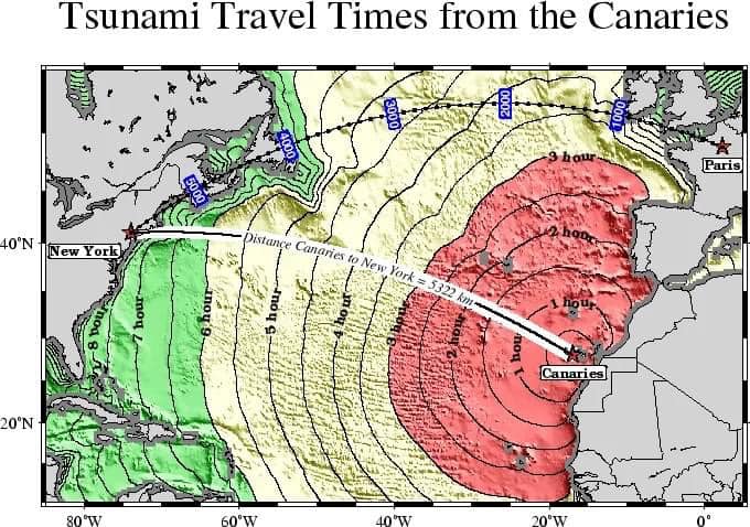
Assuming a collapse of 500 cubic kilometers (120 cu mi) that moves at a rate of about 100 meters per second (330 ft/s) on top of a layer of mud or landslide breccia, which lubricate its movement, and eventually spreads 60 kilometers (37 mi) to cover a jug-shaped area of 3,500 square kilometers (1,400 sq mi), they estimated the following timing of the tsunami:
- 2 Minutes: A 900 meters (3,000 ft) thick dome of water rises above the landslide.
- 5 Minutes: The dome collapses to a height of 500 meters (1,600 ft) as it advances by 50 kilometers (31 mi); additionally, wave valleys form.
- 10 Minutes: The landslide is now over. Waves reaching heights of 400–600 meters (1,300–2,000 ft) hit the three western Canary Islands.
- 15 Minutes-60 Minutes: 50–100 meters (160–330 ft) high waves hit Africa. A 500 kilometers (310 mi) wide train of waves advances across the Atlantic.
- 3–6 Hours: The waves hit South America and Newfoundland, reaching heights of 15–20 meters (49–66 ft) and 10 meters (33 ft), respectively. Spain and England are partially protected by La Palma, thus tsunami waves there only reach 5–7 meters (16–23 ft).
- 9 Hours: Waves 20–25 meters (66–82 ft) approach Florida; they are not expected to grow farther as they hit the coast.
- France and the Iberian Peninsula would be affected as well.
Traces of past such tsunamis may be found in the southeastern United States, on the continental shelf, in northeast Brazil, in the Bahamas, western Africa.
This movie below shows a physics-based computer simulation of a Mega Tsunami generated by a flank collapse of La Palma, Canary Islands. The movie focuses on the maximum expected runup of the waves on the shores of the Atlantic Ocean.
Other examples of tsunamis triggered by the collapse of volcanoes
Large collapses on volcanoes have generated tsunamis. In total, volcanically generated tsunamis are responsible for about 20% of all fatalities related to volcanic eruptions. Here a list of the most recent ones:
- The 2018 Sunda Strait tsunami caused by a flank collapse of Anak Krakatau (at least 437 fatalities)
- The 2002 Stromboli tsunami (severe damage to coastal settlements)
- The 1958 Lituya Bay tsunami that triggered the highest wave in history
- The 1929 Grand Banks earthquake
- The 1888 Ritter Island tsunami known as the largest historical tsunami-forming collapse with a volume of 5 cubic kilometers (1.2 cu mi) and which killed about 3,000 people.
- The 1792 Shimabara collapse of Unzen volcano in Japan which claimed 4,000 or 14,538 victims.
Ancient landslides that triggered tsunamis
Prehistoric landslides that caused tsunamis include:
- The Storegga slide 8,200 years ago, a 3,000 cubic kilometers (720 cu mi) submarine landslide off Norway that generated a tsunami recorded from geological evidence in the Faroe Islands, Norway and Scotland.
- Collapse of Fogo volcano about 73,000 years ago triggered a tsunami that inundated Santiago, Cape Verde
- Landslide-induced tsunamis at Kohala and Lanai in the Hawaiian Islands
Tsunamis are less common in the Atlantic Ocean than in the Pacific or the Indian oceans, but they have been observed e.g. after the 1755 Lisbon earthquake. Apart from fault lines, submarine volcanoes such as Kick’em Jenny and landslides are sources of tsunamis in the Atlantic.
Tsunamis are not just known from the sea: the Vajont Dam disaster in 1963 claimed 2000 fatalities and was caused by lake-level tsunami and evidence of past tsunamis is recorded from Lake Tahoe.
Humanity has never witnessed enormous collapses on La Palma and there is evidence that the western flank of La Palma is currently stable.
But as a Cumbre Vieja landslide tsunami may constitute a threat to Brazil, Canada, Caribbean, Ireland, Morocco, the Northeastern United States, Portugal and the United Kingdom, the current seismic unrest clearly need more monitoring. And aside from the tsunami hazard, the impact of a large collapse on people living on the island would be severe. The communities of El Paso, Fuencaliente, Los Llanos and Tazacorte are located on the unstable block. Cumbre Vieja is largely unmonitored and a flank collapse may begin with little forewarning. [IGN]
So the only thing I can say is be prepared or get ready. The La Palma Eruption/Megatsunami will be unprecedented!
Now subscribe to this blog to get more amazing news curated just for you right in your inbox on a daily basis (here an example of our new newsletter).
You can also follow us on Facebook and/ or Twitter. And, by the way you can also make a donation through Paypal. Thank you!
You should really subscribe to QFiles. You will get very interesting information about strange events around the world.


When the volcano erupts, the east coast of the United States will be worse the the Japan tsunami. I suspect with all the activity the magma chambers are expanding. If the quake swarms continue through this week I will be headed to the mountains I don’t care if its in a tent.
https://www.thegatewaypundit.com/2021/09/california-man-arrested-near-u-s-capitol-bayonet-machete-pickup-truck/
LEFTISTS ARE NAZI.
NATIONAL SOCIALIST PARTY
WEAK ATTEMPT AT FALSE FLAG. WATCH HOW MEDIA MANIPULATE NARRATIVE TO BE A WHITE SUPREMACIST TRUMP SUPPORTER.
VERY PREDICTABLE DISINFO WILL BEGIN SHORTLY.
Same crap, different flies.
https://www.thegatewaypundit.com/2021/09/fck-biden-hundreds-trump-supporters-greet-joe-biden-arrives-boise-idaho-video/
Yay Idaho
?????F biden
https://www.thegatewaypundit.com/2021/09/fec-dismisses-claims-twitter-violated-election-law-blocking-posts-hunter-bidens-laptop-computer-showing-prostitution-drugs-criminal-dealings/
More corruption from bribed or blackmailed pedosatanists and perverts.
??? F biden and his band of dirtbags.
https://headlineusa.com/the-myth-that-hurricanes-are-getting-worse-because-of-climate-change/
No storms are not turbocharged by global warming. The article craps on baloney science.
???????
https://www.thegatewaypundit.com/2021/09/biden-caught-telling-another-whopper-falsely-claims-first-job-offer-came-lumber-company-boise-company-says-not-true-video/
Another lie, and F biden gets busted again. Too bad liars don’t suffer internal spontaneous combustion and just burst into flames.
https://www.thegatewaypundit.com/2021/09/fck-biden-trump-supporters-gather-protest-governor-newsoms-campaign-rally-joe-biden-socal-video/
Great example of American Chinese vs redchineseys.
American Chinese say F biden in English. Hahahaha.
Love these protestors.
Kudos!
??????????F biden
https://www.thegatewaypundit.com/2021/09/white-house-cuts-feed-biden-attempts-ask-question-idaho-video/
White House cuts feed on the incompetent pervert. I guess he was going to spew more BS, and his handlers cut him off?