A M6.0 earthquake with a reviewed magnitude of 5.9 shook Southcentral Alaska on Tuesday afternoon.
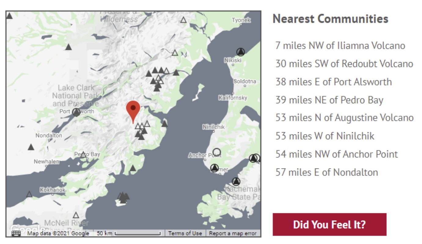
The quake was centered near Iliamna Volcano about 138 miles southwest of Anchorage. The quake was reported at a depth of 98.4 miles and shook the region at 1:42 p.m.
The jolt, which occurred across Cook Inlet from the Kenai Peninsula, was felt widely throughout much of the state, with reports from as far away as Fairbanks, Kodiak and Valdez. More than 1,500 people reported feeling it on the USGS website.
2021-12-21 M5.9 61 km E of #PortAlsworth, #Alaska #earthquake as detected by the #Scottish #RaspberryShake #seismometer network.
Clear arrivals visible on most of the stations in #Scotland.#Python @raspishake @matplotlib #CitizenScience pic.twitter.com/sJBQMSq4YP
— Giuseppe Petricca (@gmrpetricca) December 22, 2021
No immediate damage was reported following the quake, said seismologist Lea Gardine with the Alaska Earthquake Center.
“This one was on the deeper side,” she said. “If it was more shallow, it definitely would have (caused damage), but it’s not uncommon for ones of this size, at this depth, to not cause any significant damage.”
5.9 earthquake today and 4.5 inches of snow ❄️ yesterday. Alaska is rocking and rolling! ????????Minor damage was had except for the middle house ?, or did the elves start eating it? #OBW @w_white18 pic.twitter.com/qFlzKaXP8z
— Arcticsnowman ⛄?⛄?⛄? (@arctic2000) December 21, 2021
The earthquake did not immediately appear to be an aftershock, Gardine said.
It was centered close to where a 7.1 quake occurred in 2016, but Gardine said the earthquakes appear to be separated enough that it is unlikely Tuesday’s quake was an aftershock. The 2016 earthquake destroyed several homes on the Kenai Peninsula and damaged roadways.
An earthquake with a magnitude of 5.9 occurred in the US state of Alaska at 13:42 local time, 152.6 km below the ground. #Earthquake #Alaska pic.twitter.com/Z777WAf5F7
— jeo gaste (@jeogaste) December 21, 2021
Smaller aftershocks from the latest earthquake will occur in coming days and weeks, Gardine said.
“There will be aftershocks,” she said. “But usually on average they tend to be about a magnitude unit lower than the main shock. Again, that’s an average and they could be the same size or very close to. … It’s definitely possible in the coming days to week that there’ll be a magnitude 4 that will be felt.”
A tsunami was not expected to follow Tuesday’s quake, according to the National Tsunami Warning Center.
Thanks for your patience, everyone. The seismologist reviewed information for that earthquake is a deep (~95 miles) M5.9 event near Iliamna Volcano, across Cook Inlet from Nanilchik. https://t.co/u2kaTprHzy pic.twitter.com/nBtK3hmRhY
— Alaska Earthquake Center (@AKearthquake) December 21, 2021
The Alaska quake came just one day after a 6.2 magnitude earthquake shook part of northern California on Monday.
The quake, which was centered off the coast about 210 miles northwest of San Francisco, caused significant shaking but was expected to result in minimal damage in the sparsely populated area.
Residents as far away as Sacramento and the San Francisco Bay area reported feeling trembling.
Iliamna volcano
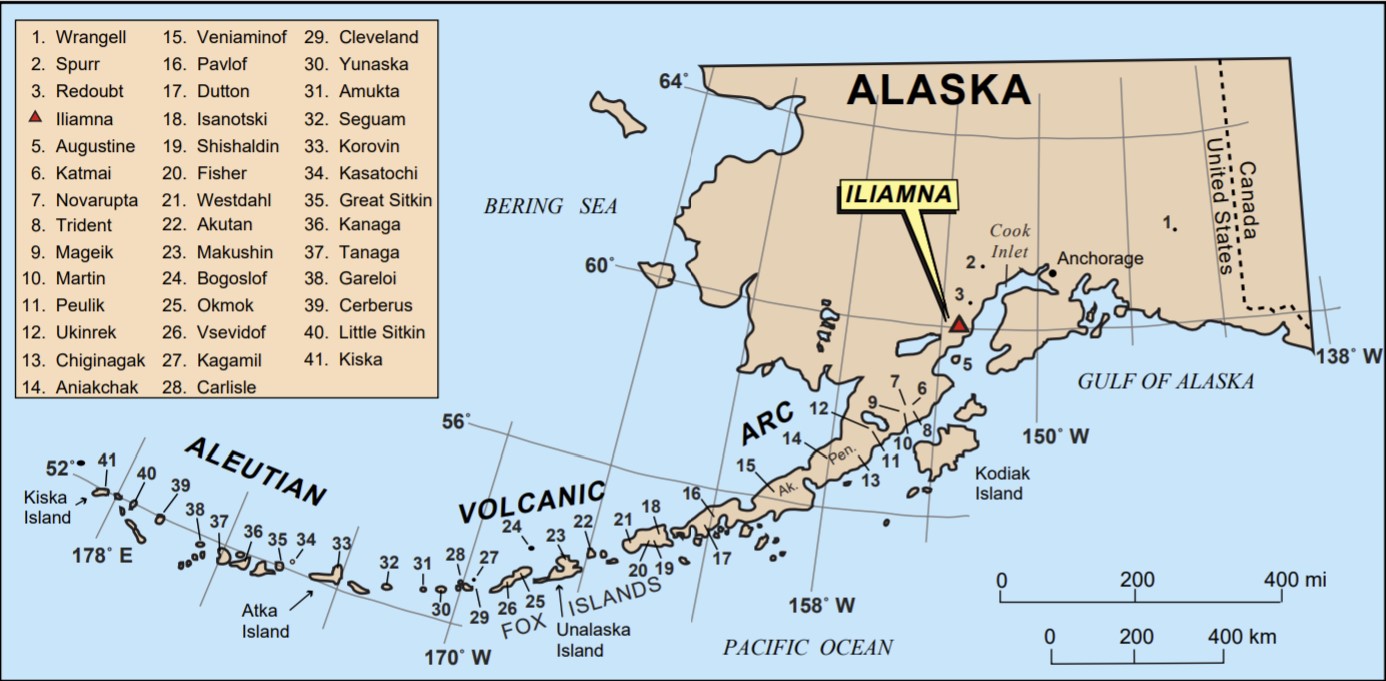
Iliamna is cone-shaped active stratovolcano that soars to 10,016 feet tall from nearby Cook Inlet, in the Chigmit Mountains within Lake Clark National Park and Preserve.
Recent Activity
In 1958 the volcano was sending up four columns of vapor from vents in the precipitous eastern face.
The last eruption was in 1867; since then smoke, and possibly light ash, was ejected in 1876, 1933, 1941, and again in 1947.
A reported ejection of smoke and some light ash in the late winter of 1956 or early spring of 1957 has not been confirmed.
If intesrested, here is a great article about the Iliamna eruption hazards.
Always be prepared if you live nearby a volcano and on the Ring of Fire! [ADN, NPS, USGS]
Now subscribe to this blog to get more amazing news curated just for you right in your inbox on a daily basis (here an example of our new newsletter).
You can also follow us on Facebook and/ or Twitter. And, by the way you can also make a donation through Paypal. Thank you!
You should really subscribe to QFiles. You will get very interesting information about strange events around the world.


Seems like I predicted the next quake within 72 hours as I wrote on previous article. However, the magnitude was 1.0 lower.
Still, I’ve seen this type of pattern after 60 years. It goes like that on left coast.
will the next larger quake hit between alaska and california, a dutchsense idea?