The Flinders River has gone from thin and dry to 37 miles (60 kilometers) wide in a matter of weeks as a result of floods in northeast Australia, satellite imagery shows.
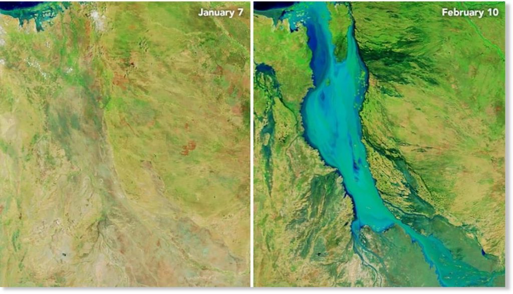
Images released by NASA show the change to the Flinders River – one of Australia’s longest waterways – over the past month, with flooding there at its worst in more than half a century.
The #FlindersRiver is experiencing its most significant flooding in more than 50 years with major flooding to continue well into next week. Flood plumes spill into the Gulf of Carpentaria as seen from Japan's Himawari-8 satellite: https://t.co/bZgs9WKObB pic.twitter.com/cr2S4N9RUX
— Bureau of Meteorology, Queensland (@BOM_Qld) February 13, 2019
CNN meteorologists analyzed the image and said it appeared the river had swelled 60 kilometers wide at some points.
The river is now so big it’s creating its own weather system.
The Queensland Bureau of Meteorology (BOM) said extra moisture from the flooding helped create a thunderstorm early Thursday.
A flood so vast it creates its own weather! The extra moisture from the flooding in #NWQld helped this thunderstorm form this morning. It can be seen following the path of the flood waters very closely, thankfully falls were isolated. More images: https://t.co/nrb8tKt1K1 #BigWet pic.twitter.com/zPHnElj50k
— Bureau of Meteorology, Queensland (@BOM_Qld) February 14, 2019
Australia’s billion-dollar beef industry is expected to sustain heavy losses due to the storms. About 500,000 cattle are believed to have died in the flooding.
Many of the cattle carcasses remain, and will pose a health hazard if not buried or burned.
“People have gone through drought, they have come out of years and years of drought, and they have now gone smack-bang into a natural disaster the likes of which no one out there has seen before,” Queensland Premier Annastacia Palaszczuk said.
Follow us on Facebook and Twitter or become a Patron on Patreon / donate through Paypal. Please and thank you
[CNN]


")


