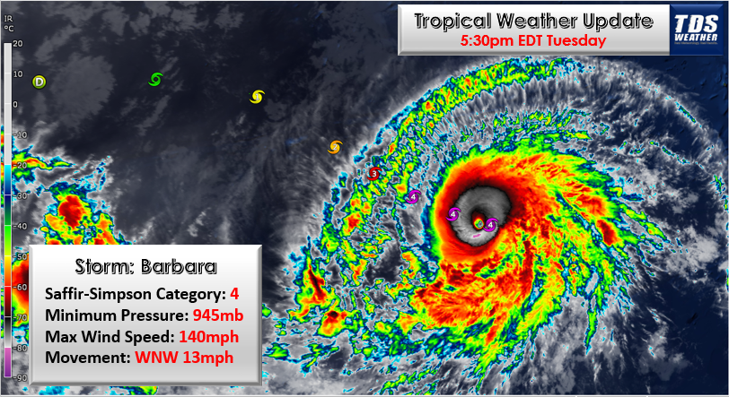
Barbara has become the Eastern Pacific’s first major hurricane (Category 3 or higher) of the season.
In less than 24 hours, the storm has exploded from a tropical storm to a Category 4 on Tuesday and is forecast to become a Category 5 with maximum sustained winds of at least 157 mph.

On Monday, Barbara quickly became the first hurricane of the 2019 season in the Eastern Pacific and is now a monster hurricane running loose over the open waters of the basin just 24 hours after it was a tropical storm.
Here’s an up-close look at the eye of now Cat. 4 #HurricaneBarbara, as seen by #GOESWest. Barbara is packing maximum sustained winds of nearly 130 mph. More imagery: https://t.co/au0BIQroLJ pic.twitter.com/YbS1ozH8qN
— NOAA Satellites (@NOAASatellites) July 2, 2019
Essentially, Tropical Storm Alvin, which was late to form as the first storm of the season in the East Pacific, helped to pave the way for Barbara and pull a plume of tropical moisture farther north from the equatorial region.
This created an ideal environment for a tropical storm to ramp up quickly through hurricane rankings.
“Given the anticipated track of Barbara, which will keep it in warm waters, tropical moisture and low wind shear through midweek, we expect the hurricane to become a Category 5,” according to AccuWeather Tropical Meteorologist Adam Douty.
Sunset on Barbara The Beast. pic.twitter.com/3tyr7hAJrd
— Dakota Smith (@weatherdak) July 3, 2019
A Category 5 hurricane is the most powerful tropical storm on the Saffir-Simpson Hurricane Wind scale.

Barbara may become the third earliest Category 5 hurricane to form in the Eastern Pacific during the satellite era, according to the National Hurricane Center. The earliest was Ava in 1973 and Celia in 2010. Ava became a Category 5 hurricane on June 7, and Celia strengthened into a Category 5 on June 25.
However, Barbara’s northwesterly track will bring the hurricane into progressively cooler waters well east of Hawaii later this week, leading to weakening.
#Hurricane #Barbara now has maximum sustained winds of 155 mph – making it the strongest "B" hurricane in the eastern North Pacific on record (since 1971). pic.twitter.com/HRbsekX8pS
— Philip Klotzbach (@philklotzbach) July 3, 2019
“While Barbara will not unravel as fast as Alvin did, it is likely to weaken to a tropical storm late this week or this weekend and then to a disturbance by next week,” Douty said.
Hawaii touch down?
Waters are warmer than average around Hawaii, but they may not be warm enough to sustain a tropical storm, let alone a hurricane at this point of the season.
Even so, as a tropical depression, wave or disturbance, Barbara is likely to bring showers and thunderstorms to parts of Hawaii around next Tuesday.
Residents and visitors on the islands should monitor the progress of Barbara.
“During Tuesday, Wednesday and Thursday of next week, there can be localized flooding downpours and gusty thunderstorms with rough seas and surf that spread westward over parts of the islands,” Douty said.
However, the exact track and strength of the feature next week will determine the extent and intensity of the conditions.
#HurricaneBarbara rapidly developed while we were sleeping. Latest measurements show Cat 4 winds sustained at 130 mph. Barbara weakens, only producing dangerous surf & t'storms for #Hawaii. pic.twitter.com/bIwfvkVZ3S
— Mike Nicco (@MikeNiccoABC7) July 2, 2019
Barbara could arrive and bring impacts just days after an unusual rain event in Hawaii. During the last week of June, a non-tropical storm system brought drenching downpours and produced localized flooding over parts of Hawaii.
Honolulu received more than 5.50 inches of rain spanning June 25 and 26. Normal monthly rainfall for Honolulu during June is a mere 0.26 of an inch. The city is typically in the rain shadow of mountains to the north and northeast.
In the Northern Hemisphere, there is a belt of prevailing winds that blow from the northeast in the tropical regions. Hawaii experiences the northeasterly trade winds which cause frequent rain on the northern- and eastern-facing shoreline and very little rain on the southern- and western-facing shores. Tropical and non-tropical storms can disrupt this pattern.
Scott Fisher Says: Hurricane Barbara #barbara #hurricanebarbara pic.twitter.com/JVhj97EEqx
— Scott Fisher (@ScottFisherFOX7) July 3, 2019
Barbara could potentially spread rainfall into areas that typically do not receive rainfall during this time of the year.
Most recent hurricanes in the Est Pacific
At this time, Barbara’s main threat is to ships, including those that approach or depart from the Panama Canal over the Pacific Ocean.
Swells will slowly propagate outward from the hurricane and can create rough surf conditions along the western coast of Mexico later this week and eventually part of Southern California and the west-facing shoreline of the Big Island of Hawaii this weekend.
Oh I miss this kind of action in the West Pacific. #Barbara pic.twitter.com/mQePntbZmm
— Emmanuel Enriquez (@WXappraiser) July 3, 2019
The most recent Category 5 hurricane in the East Pacific was Willa during late October of 2018, but the storm did not reach Hawaii. Overall, there were 10 major hurricanes in the Eastern Pacific last year. The first Category 4 hurricane to form in the basin was Aletta in early June. Later, Hurricane Lane reached Category 5 status during August and went on to impact Hawaii in a greatly weakened state.
Meanwhile, conditions in the Atlantic basin remain unfavorable for tropical development into this weekend. However, some parameters that have been inhibiting tropical development over the Atlantic may weaken toward the middle of July.


