For the first time in more than a decade, the state has remapped the tsunami evacuation zones for California. The Bay Area could be in grave danger if an earthquake-driven tsunami hits our shores.
Preparing for natural disasters is what many of us do in the Bay Area. Now, state geologists say a once-in-a-lifetime tsunami could inundate more of the Bay Area than first thought.
The Bay Area learned first hand what the force of a tsunami can do when an earthquake struck Japan in 2011, sending strong waves surging into Santa Cruz Harbor, leaving heavy damage.
Now state geologists are giving us, updated information about where a major tsunami could strike around the Bay Area.
“We don’t want to scare people, maps looking at an extreme event that we won’t see in our lifetime, but its good to prepare,” said Rick Wilson from the California Geological Survey.
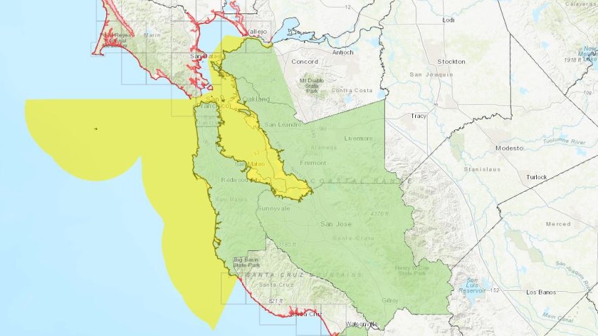
New technology has allowed the California Geological Survey to update its tsunami hazard maps from 2009, with a perfect storm in mind.
“We are preparing for a worst case scenario. A 9.3 magnitude quake off Alaska, that would be the worst case for San Francisco,” said Adrienne Bechelli, Deputy Director of San Francisco’s Department of Emergency Management.
In the East Bay, new maps show the event could bring tsunami waves into parts of West Oakland, and Lake Merritt.
Along San Francisco’s waterfront, it could be bad
It was first thought the surge from a tsunami would reach as far as the ferry building and the Embarcadero, but new mapping shows it could reach in the Financial District as far as Fremont Street.
Tsunami waves could also reach parts of North Beach from Fisherman’s Wharf.
“Especially in the Bay Area, tsunami heights may not be that large, but there’s a potential for a tsunami to knock people down and injure them,” Wilson added.
San Francisco already has tsunami evacuation routes posted, but many will have to be updated.
“So when when in doubt, get to higher ground away from the coast,” Bechelli added.
Many people say the threat of a tsunami isn’t something they can deal with right now.
“I’ll read up on it, but after the year we’ve had, I can’t live in fear, we live in quake country,” said El Cerrito resident Lois Moore.
Officials urge residents to have a plan, and sign up for emergency alerts where you live.
If you want to find out if you live in a tsunami hazard zone… Just look at the map here… (i think the website is currently down… I don’t know why… More information available here too (map down but other very important ressources)… [NBC Bay Area]
Now subscribe to this blog to get more amazing news curated just for you right in your inbox on a daily basis (here an example of our new newsletter).
You can also follow us on Facebook and/ or Twitter. And, by the way you can also make a donation through Paypal. Thank you!
You should really subscribe to QFiles. You will get very interesting information about strange events around the world.


")


")

Hmmm, technofascist apocalypse? Perhaps this would be a benefit to humanity.
Perhaps God will usurp your right to exist, since you wish to usurp our right to free speech. Most of the technofascists are extreme perverts too.
Oh Great, we must lead a charmed life?
https://humansarefree.com/2021/07/america-has-been-overthrown-by-the-satanic-cult.html
Ye shall know them by their fruits. Do men gather grapes of thorns, or figs of thistles?
—Matthew 7:16