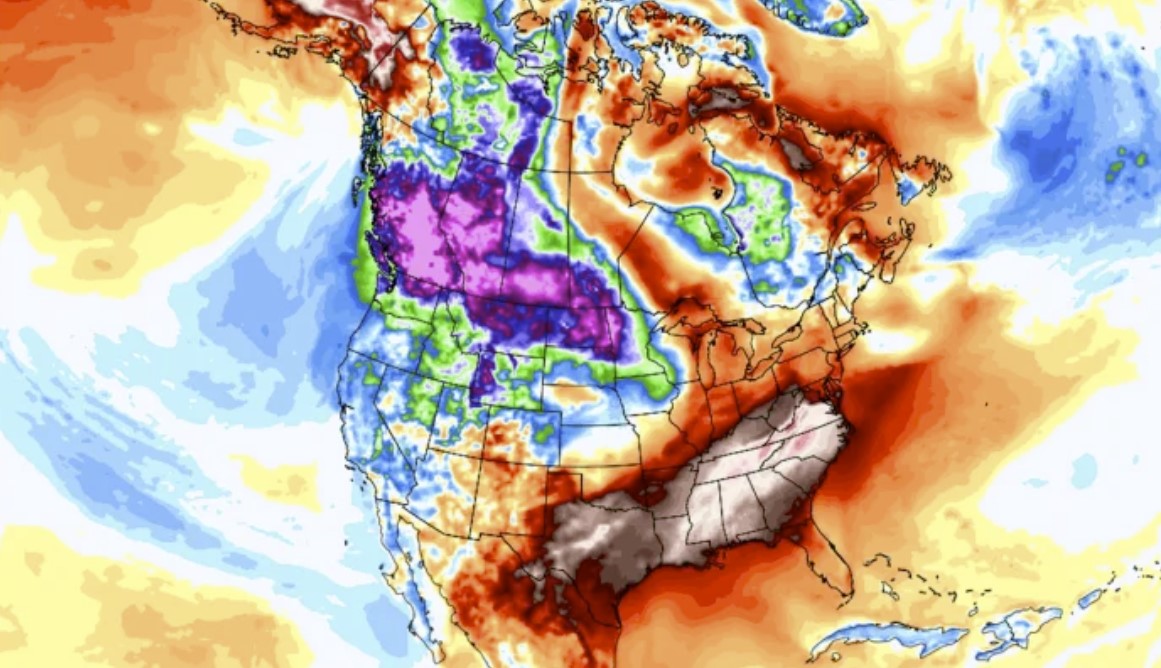
California’s ski resorts are digging out from under 5 to 9 feet of snow that has fallen over the last several days from a series of storms. And more snow is on the way.
10:38 | #mtnupdate: The dig out continues! Here are some photos from mid-mountain of our teams digging out the day lodge. It’s DEEP! pic.twitter.com/yawy3Fq4a5
— Northstar Mtn Update (@northstarmtn) December 27, 2021
A large dip, or trough, in the jet stream across the West is allowing frigid conditions and a relentless series of storms to bring record-breaking snowfall into the Sierra Nevada Mountains. The snow has closed major interstates and even forced the shut down of several ski resorts.
Lake Tahoe snow dogs making fresh tracks pic.twitter.com/daTEDJld8k
— Wu-Tang Is For The Children (@WUTangKids) December 27, 2021
According to the National Weather Service, between 6 and 9 feet of snow has fallen in the Sierra Nevada Mountains since Wednesday. Northstar California Resort picked up 15 inches of new snow since Monday.
12.28 | #MtnUpdate: Good morning! The mountain received 15″ at the summit and 12″ at mid-mtn in the past 24 hours! Our teams are just getting onsite now to continue the work they started yesterday. At this time expect a DELAYED OPENING. Please be patient!
— Northstar Mtn Update (@northstarmtn) December 28, 2021
Some one-week snowfall totals may eclipse 10 feet as more storms bring additional rounds of snow through Wednesday.
From viewers in Lake Tahoe this week. More snow forecasted this week, but road conditions are starting to look up! @KTVU pic.twitter.com/y63tEGhRqP
— James Torrez (@JamesTorrezNews) December 28, 2021
At UC Berkeley’s Central Sierra Snow Lab, 202.1 inches have fallen in December, making it the snowiest such month on record there, and the third-snowiest month of all time.
8.4″ (21.4 cm) of #snow in the last 24 hours brings December’s total to 202.1″, which makes it the third snowiest month on record here (back to 1970).
A spot of sunlight peaked through the clouds this morning, but it won’t last long with more snow on the way.#CAwx #CAwater pic.twitter.com/vfGs19w9Ow
— UC Berkeley Central Sierra Snow Lab (@UCB_CSSL) December 28, 2021
The snow is good news for a state that entered the winter mired in drought, since winter snow cover is used for water resources during the dry season. While parts of the state are still designated as being in “exceptional” drought, the worst category on the scale, Northern California is seeing meaningful relief.
Road traffic is beginning to reopen in parts of the Sierras, but closures continued Tuesday morning for important routes, including across the California-Nevada border.
@CaltransDist3 working to clear snow on I-80, as it remains closed this morning from Colfax to the Nevada State Line. #cawx #PCSO #PlacerCounty #LakeTahoe #snow pic.twitter.com/D1V2OTVRxI
— Placer Sheriff (@PlacerSheriff) December 28, 2021
In addition to the snow, much of the West, including Seattle and Portland, Oregon, are experiencing unusually cold conditions, as an Arctic air mass seeps across the Canadian border. The Weather Service warned of the potential for hypothermia and frostbite in Seattle, where overnight lows have hovered near 20°F.
In Portland, even colder temperatures are expected again Tuesday night on the eastern side of the city, as air temperatures plummet in the Columbia River Gorge. Wind chills could hover close to 0°F, and there is a risk of pipes bursting in homes, the Weather Service warned.
However, the cold weather in the Pacific Northwest pales in comparison to the frigid conditions moving into Montana and the Dakotas. There, wind chills are expected to reach minus-50°F Tuesday night, with daytime high temperatures failing to rise above 0°F during the day on Tuesday, Wednesday and Thursday.
*Corrected tweet*
Wind chills as low as 50 degrees below zero today through New Year’s Day. Frostbite will occur within in minutes on exposed skin. #ndwx pic.twitter.com/DnuEYTerNf
— NWS Bismarck (@NWSBismarck) December 28, 2021
Wind chills that low can cause frostbite on exposed skin within just a few minutes, the NWS warned.
The next few days will feature more of the same, with a cold, unsettled weather pattern in the West, and high avalanche danger in the Sierras. Frigid conditions will become firmly established in the northern Plains, and gradually shift southeastward into Minnesota, based on computer model projections.
The heart of the cold air lies to the north, across British Columbia, where some of the coldest conditions since the 1960s are occurring. Temperatures in many locations are not rising above the minus-teens Fahrenheit for daytime highs this week, an unusual occurrence for this province.
British Columbia is in the running for the top spot in North America for extreme weather events in 2021, with a scorching heat wave and related wildfires last summer, devastating floods in the fall and now this once-in-a-generation cold snap. Lytton, B.C., reached 121°F on June 29 to set the country’s all-time record high, only to burn in a fire the next day.
Tahoe shatters 50-year December snowfall record
With four days left to go in the month, Tahoe has already broken the record for December snowfall set 50 years ago.
On Monday, December snow totals at the UC Berkeley Central Sierra Snow Lab reached 193.7 inches, blowing a 1970 record of 179 inches out of the water.
LAKE TAHOE, Nev. With four days left to go in the month, Lake Tahoe has already broken the record for December snowfall set 50 years ago! December snow totals at the UC Berkeley Central Sierra Snow Lab reached 193.7 inches, blowing a 1970 record of 179 inches out of the water.?
— Left Lane Lois????? (@LeftLois) December 28, 2021
With 23 inches of snow over the last 24-hours, Lake Tahoe has now climbed up the charts to 2nd snowiest December on record month-to-date behind 1931. To finish off 2nd, just another 7.6 inches of snow needs to fall over the next four days. 15.6 is needed to set a new record. ? pic.twitter.com/kGs2AXTy8Z
— Chris Martz (@ChrisMartzWX) December 28, 2021
Today, the lab, located at Donner Pass, has received roughly 23 inches of snow in the past 24 hours and broke the 200-inch mark, wit 202.
SNOWIEST DECEMBER ON RECORD! @UCB_CSSL located at Donner Summit (elev 6894’) has reported the storm total is 118″, and the December total to 202″ so far. That officially smashes the snowiest December since at least 1970 when the record of 179” was set. #truckee #laketahoe pic.twitter.com/2aWt3KD1qZ
— We Dream Big… (@wedreambig) December 28, 2021
The lab was built in 1946 by the U.S. Weather Bureau and Army Corps of Engineers and maintains one of the longest-running manual snow depth records in the world, dating back to 1879.
“This has been a very beneficial storm for the Sierra region,” said Dan McEvoy, regional climatologist for the Western Regional Climate Center.
The Lake Tahoe Basin is sitting around 200 percent of average for snow water equivalent – the amount of water that will be released from the snowpack when it melts – for this time of year.
And the Basin is sitting at 60 percent of its peak average snow water equivalent, which occurs around late March or early April, McEvoy said. The median peak average is 27 inches, and today 16.1 inches of snow water equivalent was measured, he said.
December’s storms came in “forming a right-side-up snowpack,” he said. Earlier storms were wetter with higher elevation snow, but then temperatures and snow levels dropped.
“That’s good for both water content and avalanche concerns,” McEvoy said.
It will also help keep the snowpack for area ski resorts in good shape, even if the region runs into a dry spell.
“It’s been a pretty impressive December,” McEvoy said.
But, he cautioned, it’s possible for drought conditions to resume.
“If I had to emphasize one point, it’s that the drought’s not over. We need the storms to continue through the winter.”
Chaos all along the Pacific Northwest
Snow showers began in the Northwest on Sunday from the Gulf of Alaska, dumping up to 6 inches (15 centimeters) across the Seattle area. Another storm dropped more snow in western Washington and Oregon late Monday and Tuesday.
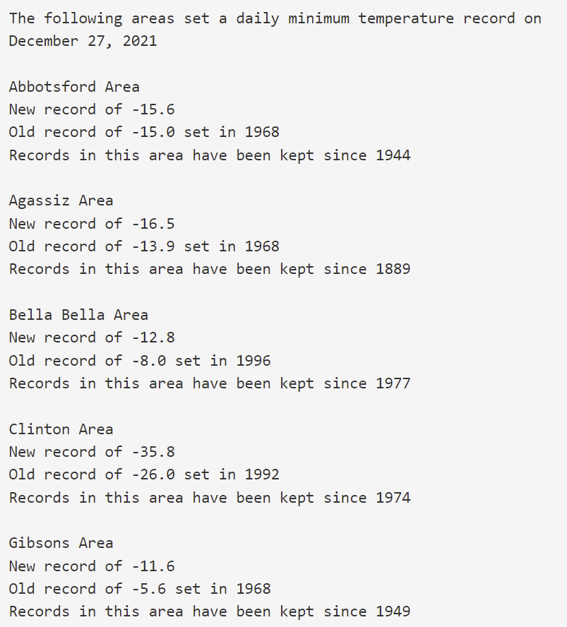
The region continued to break daily cold records. The National Weather Service said the low was 17 degrees F (-8.3 C) in Seattle on Monday, breaking a record set in 1968. Bellingham, Washington, plunged to 7 F (-13.9 C) on Monday, tying a record set in 1968.
Another round of record lows were set & tied yesterday on 12/27:
Sea-Tac AP: 17°; old record 20° in 1968
NWS Seattle: 17°; old record 23° in 1968
Bellingham: 7°; ties old record 7° in 1968
Hoquiam: 21°; old record 25° in 1978#wawx— NWS Seattle (@NWSSeattle) December 28, 2021
In Seattle, the city said garbage pickup was canceled for Tuesday, as side streets remained treacherous. And another round of snow was predicted for the Seattle and Portland, Oregon, areas on Thursday.
TIME LAPSE: The Oregon Coast is waking up to even more snow on the ground. What a view on this Monday morning! #Seaside #ORwx pic.twitter.com/XdgmsnFMtb
— Jeff Forgeron (@WeatherJefe) December 27, 2021
State officials in Oregon have declared an emergency. In Multnomah County — home to Portland — about a half dozen weather shelters were open. Seattle city leaders also opened at least six severe weather shelters and the mayor declared an emergency.
Warming shelters in Multnomah County were around 75% full on Monday night, with 339 people.
Hope you are fine! [Reno Gazette Journal, Axios, AP]
Now subscribe to this blog to get more amazing news curated just for you right in your inbox on a daily basis (here an example of our new newsletter).
You can also follow us on Facebook and/ or Twitter. And, by the way you can also make a donation through Paypal. Thank you!
You should really subscribe to QFiles. You will get very interesting information about strange events around the world.

 scorches Brazil’s Rio de Janeiro")


Stupid-headline-mageddon, idiot-editor-pocalypse.
At the end of the day, having said that, jaw-dropping writer doubles down and skyrockets with spiraling internet jargon.
Happy New Year!
My prediction for 2022:
This year will suck worse than 2021. Been that way forever. After six decades, nothing gets better. Only gets exponentially worse with each passing year. The only thing that could change this pattern is if Christ returns to earth. Otherwise, we’re fcked.
Colorado had some 100mph whipping up a fire.
Damage and evacuations.
While the climate alarmist falsely proclaimed we are going into Global warming or what is now called Climate change. The reality is the world is going into a Maunder Minimum. Look at the work from solar astronomer John Eddy and E.W. Maunder, an English and German scientist Gustav Spörer, notated the decrease in solar activity. They are real scientist, not the face science of Obama, AOC or Al Gore.
Thanks. Clear as mud.
All of this is just a NORMAL winter in Idaho, especially in the Northern Panhandle!
We get feet of snow and temperatures below zero on a regular basis.
Of course places like Portland and Seattle don’t experience these extremes.
No drought propaganda in those areas will gain traction. Near Grand Canyon we have snow too. Been stacking logs this morning. Plenty of wind, and snow clouds inbound.
Put a fan behind my woodburning stove. Blows the heat into kitchen. Then I have a fan in the kitchen that blows heat down hallway toward bedrooms. 74° all day long as long as wood is burning.
Snowed 2″, puny.
4° tonight though, so now we will see how well my insulation double whammy tricks worked.