Weather Extremes • Storm Science
A “bomb cyclone” is not a hurricane — it’s an extratropical storm that rapidly intensifies as its central pressure drops fast enough to meet the explosive cyclogenesis threshold. Here’s the science, the pressure-drop rules, how Nor’easters fit in, and why these storms can go from “messy” to “dangerous” in hours.
Updated on: • Jump to FAQ • Jump to Historic Bomb Events
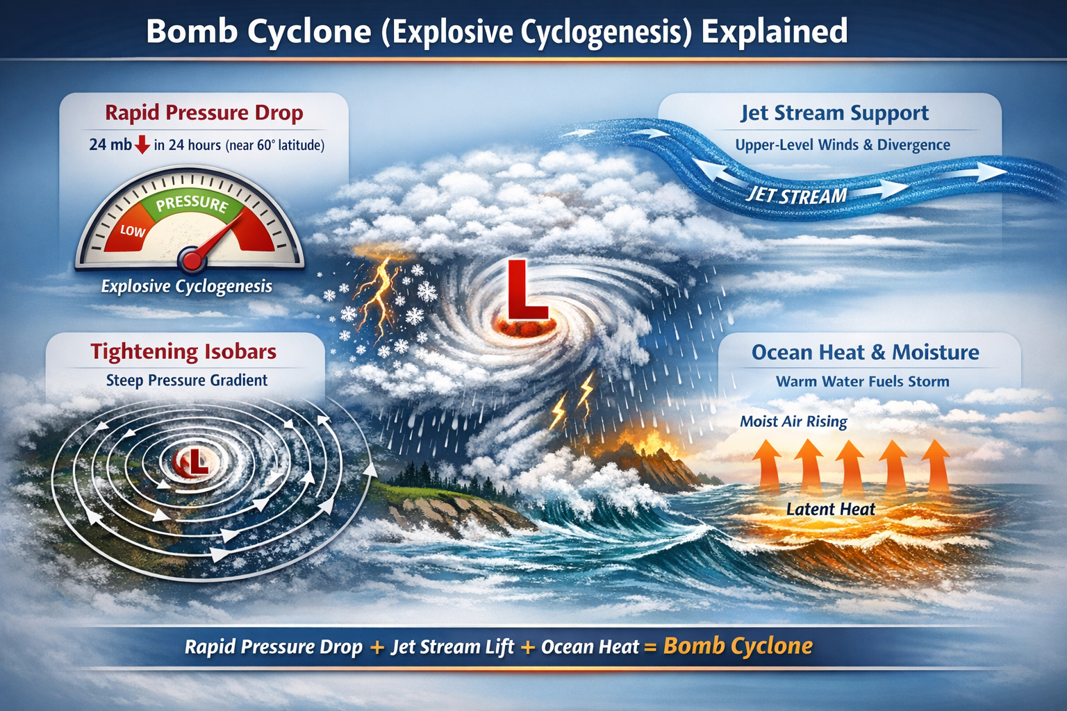
This infographic breaks down how a bomb cyclone forms through explosive cyclogenesis — highlighting the 24 mb in 24 hours pressure-drop rule, tightening isobars, upper-level jet stream support, and ocean heat fueling rapid storm intensification.
TL;DR (Key Facts)
- Bomb cyclone = a mid-latitude low that intensifies fast enough to meet the explosive cyclogenesis pressure-drop threshold.
- The classic benchmark is 24 mb (hPa) in 24 hours near 60° latitude (the threshold varies with latitude).
- “Bombogenesis” is a common media term for the same rapid-deepening process.
- Many Nor’easters qualify — but not all Nor’easters are bomb cyclones.
- Fuel = strong temperature contrast + jet stream support + ocean heat & moisture (latent heat).
- Impacts can include blizzards, hurricane-force wind gusts, storm surge, coastal flooding, and power outages.
What Is a Bomb Cyclone?
A bomb cyclone is a rapidly intensifying extratropical low-pressure system whose central pressure drops fast enough to meet the explosive cyclogenesis threshold — commonly 24 millibars in 24 hours near 60° latitude, adjusted for latitude.
A bomb cyclone is a dramatic nickname for a storm that undergoes explosive cyclogenesis (often called bombogenesis) — meaning its central pressure falls so quickly that the storm deepens at an exceptional rate. Meteorologically, this is rapid deepening driven by baroclinic instability: the atmosphere converting strong warm–cold contrasts into wind and storm energy.
Important: the word “bomb” describes how fast the pressure drops, not a specific storm type like a hurricane. These are typically extratropical (mid-latitude) cyclones, often forming over the ocean where warm, moist air meets colder air.
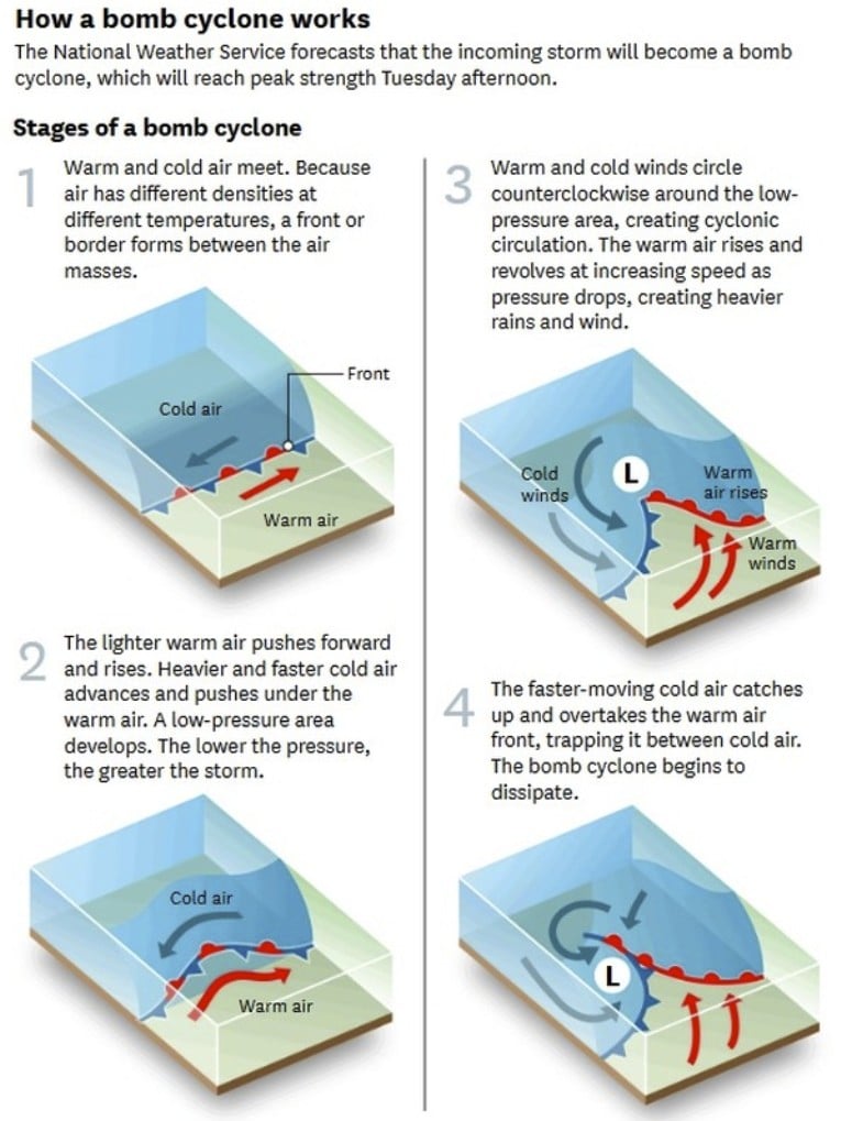
This diagram illustrates the four key stages of bomb cyclone formation, from the initial clash of warm and cold air masses to rapid pressure falls, tightening isobars, and the occlusion phase of explosive cyclogenesis.
If you’re building your StrangeSounds storm cluster, start at the Strange Weather Phenomena Sub-Hub and connect supporting explainers (jet stream, storm surge, atmospheric rivers) back to this pillar.
The 24 mb Rule (Bergeron Criterion) & Latitude Thresholds
The classic benchmark is a 24 millibar (hPa) pressure drop within 24 hours at about 60° latitude. Because Earth’s rotation effects vary by latitude, the “bomb” threshold scales with latitude — typically lower at lower latitudes.
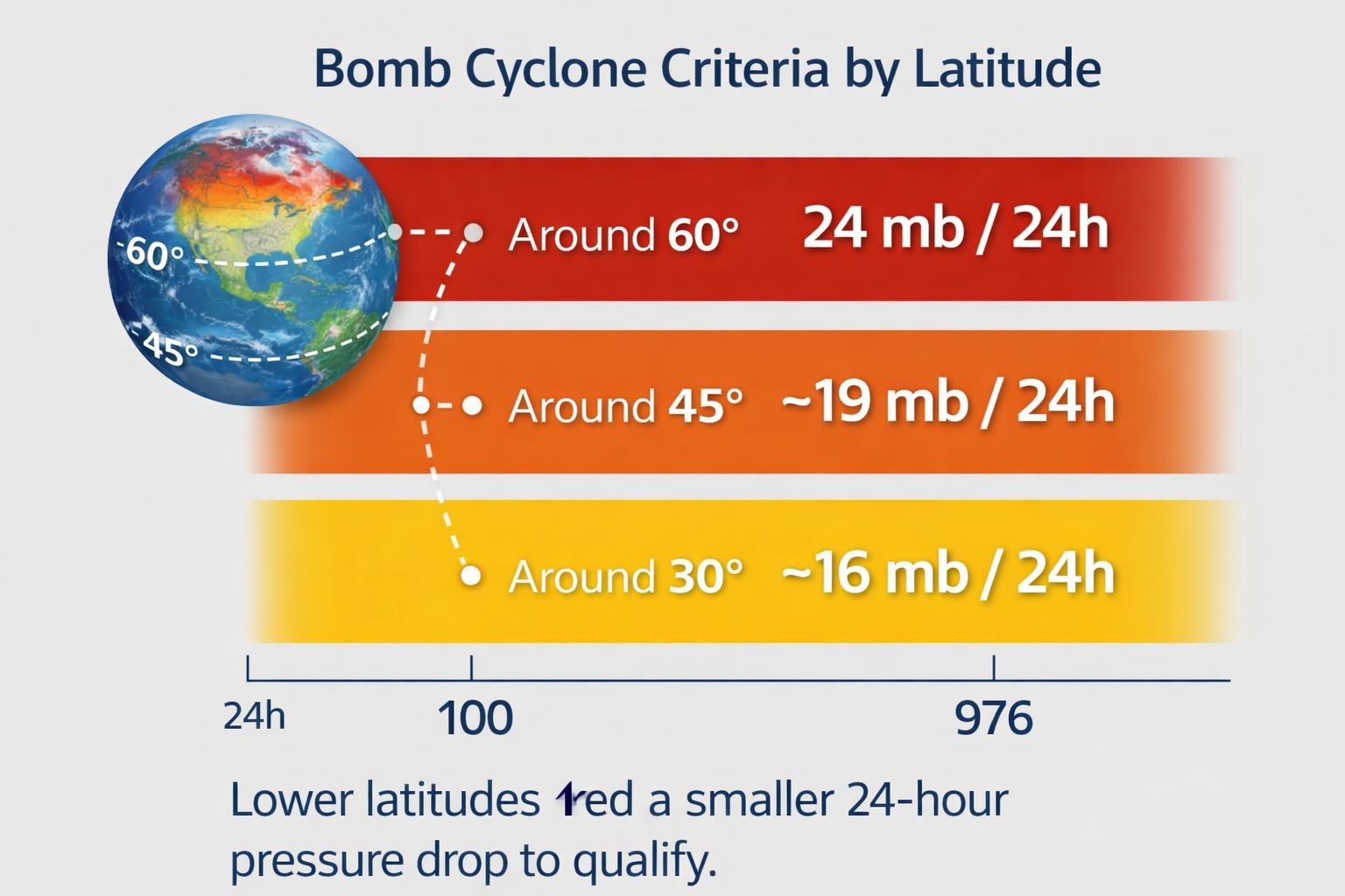
Approximate 24-hour pressure-drop thresholds by latitude
| Latitude | Approx. threshold (mb / 24h) | What it means |
|---|---|---|
| ~60° | 24 | Classic “24 in 24” benchmark |
| ~45° | ~19 | Common for U.S. Northeast / North Atlantic storms |
| ~30° | ~16 | Lower-latitude explosive deepening threshold |
Note: These are practical approximations used in education and media explanations. Operational meteorology often applies latitude-adjusted criteria precisely.
How Explosive Cyclogenesis Works
Explosive deepening happens when the atmosphere “stacks the deck” for rapid strengthening: a strong temperature contrast, jet stream dynamics, and a warm ocean surface feeding moisture and latent heat into the storm.
Ingredient #1: Strong temperature contrast (baroclinic zone)
A sharp boundary between cold and warm air creates a strong horizontal temperature gradient — a prime environment for storm development. This baroclinic setup helps convert temperature contrast into wind and storm energy.
Ingredient #2: Jet stream support (upper-level dynamics)
Upper-level wind patterns can enhance rising motion. When air evacuates aloft efficiently, surface pressure can fall faster — especially near jet streaks and strong upper-level troughs. (See: Jet Stream explained)

Ingredient #3: Warm ocean heat & moisture (latent heat)
Ocean warmth and moisture energize precipitation bands and can accelerate deepening — especially when cold air moves over warm water. Condensation releases latent heat, helping intensify the storm circulation.
Storm Structure: Cold-Core vs Warm-Core
Bomb cyclones are typically cold-core extratropical cyclones with fronts and a strong temperature gradient, while hurricanes are warm-core tropical cyclones powered by sustained ocean heat and organized convection around a central eye.
What you often see on satellite
- Comma-cloud signature (classic extratropical “hook” shape)
- Frontal bands and an evolving occlusion as the system matures
- A rapidly expanding wind field, not a compact tropical core
Some explosive cyclones can briefly develop hybrid characteristics, but the core concept remains: “bomb” describes the deepening rate, not a tropical structure.
Difference Between a Hurricane and a Bomb Cyclone
Although both can produce extreme wind and coastal flooding, a hurricane and a bomb cyclone are fundamentally different types of storms.
Core Structural Difference
- Hurricane = a warm-core tropical cyclone powered primarily by warm ocean water and organized thunderstorms around a central eye.
- Bomb cyclone = a cold-core extratropical cyclone defined by how quickly its central pressure drops (explosive cyclogenesis), not by tropical structure.
Energy Source
- Hurricanes gain energy from sustained warm ocean temperatures (typically above 26°C / 79°F) and latent heat release in deep convection.
- Bomb cyclones strengthen mainly from strong temperature contrasts (baroclinicity), jet stream dynamics, and rapid pressure gradient intensification.
Location and Season
- Hurricanes form in tropical and subtropical regions during warm seasons.
- Bomb cyclones typically form in mid-latitudes and are most common in fall and winter.
Pressure Drop vs Wind Category
Hurricanes are categorized by maximum sustained wind speed (Category 1–5 scale), while bomb cyclones are identified by the rate of pressure drop — often the equivalent of 24 millibars in 24 hours near 60° latitude.

Quick Comparison Table
| Feature | Hurricane | Bomb Cyclone |
|---|---|---|
| Core Structure | Warm-core | Cold-core (typically) |
| Main Energy Source | Warm ocean water | Temperature contrast + jet stream |
| Definition | Wind-speed based category | Rapid pressure drop threshold |
| Common Region | Tropics / Subtropics | Mid-latitudes |
| Eye Present? | Yes (typically) | No true tropical eye |
Bomb Cyclones vs Nor’easters
A Nor’easter is a regional storm type that affects the U.S. East Coast with strong northeast winds, heavy precipitation, and often coastal flooding. A bomb cyclone is a storm that meets a rapid-intensification definition.
- Nor’easter = location & wind direction pattern (regional storm identity).
- Bomb cyclone = rate of pressure deepening (physics-based threshold).
Many memorable Nor’easters “bomb out,” but plenty of Nor’easters do not meet the explosive criterion. Likewise, bomb cyclones can occur outside the Northeast — including the Atlantic near Iceland/Greenland and across the North Pacific. (See: Nor’easters explained)
Atlantic Bomb Cyclones
The North Atlantic is a classic factory for explosive cyclogenesis. Strong wintertime temperature contrasts, an active jet stream, and ocean currents can set up rapid deepening — sometimes producing blizzards and damaging coastal wind.
Common Atlantic setup
- Cold air surges southward
- Warm ocean waters feed moisture into the storm
- Jet stream dynamics enhance ascent and pressure falls
Primary Atlantic Hotspots
- New England & Maritimes: Gulf Stream heat + Arctic air contrast
- Iceland & Greenland: Polar front storm track clustering
- UK & Western Europe: Strong winter jet exit regions
This satellite image shows a powerful Atlantic bomb cyclone intensifying off the U.S. East Coast, with a tightly wrapped low-pressure center and classic comma-cloud structure characteristic of explosive cyclogenesis.

Pacific Bomb Cyclones
The North Pacific produces frequent explosive deepeners — from the Gulf of Alaska to storms affecting the Pacific Northwest. These events can bring extreme wind, heavy rain, coastal erosion, and high-elevation blizzards.
Primary Pacific Hotspots
- Gulf of Alaska: Active jet + cold outbreaks
- Pacific Northwest: Offshore frontal zone + moisture fetch
- Bering Sea: Rapid deepening in marine storm corridor
Where they hit hardest
- Pacific Northwest coasts (wind + waves + flooding)
- Coastal British Columbia / Alaska (strong pressure gradients)
- Aleutian region (powerful marine storms)
Below is a real-world satellite view of a powerful Pacific bomb cyclone offshore the U.S. West Coast, showing the classic comma-cloud structure and tightly wrapped low-pressure center during rapid intensification.

This table summarizes the global bomb cyclone hotspots:
Global Bomb Cyclone Hotspots (Quick Reference)
| Region | Main Driver | Typical Hazard |
|---|---|---|
| North Atlantic | Gulf Stream + Arctic air | Blizzards & coastal surge |
| North Pacific | Active jet + ocean heat | Hurricane-force winds |
| Western Europe | Jet exit region intensification | Windstorms & flooding |
| U.S. Interior | Lee cyclogenesis + trough coupling | Widespread severe winds |
Why Rapid Intensification Is So Dangerous
Explosive deepening can create a steep pressure gradient in a short time — which is meteorology-speak for: the winds can ramp up quickly. As isobars tighten, the pressure gradient force strengthens and wind speeds can surge within hours. (See: Storm Surge explained)

Common hazards
- Damaging wind gusts (downed trees, structural damage, power outages)
- Blizzard conditions (whiteouts, drifting, dangerous travel)
- Storm surge + coastal flooding (especially with high tide)
- Huge waves (marine hazards, coastal erosion)
- Heavy rain (urban flooding, river rises)
How to Track a Bomb Cyclone Like a Pro
You don’t need a meteorology degree to spot an explosive deepener. Watch for these signals:
- Rapidly falling pressure at the storm center (hourly drops that keep accelerating).
- Tightening isobars on surface maps (stronger pressure gradient = stronger winds).
- Banding on satellite (intense comma-cloud, strong frontal structure).
- Growing wind field (gales expanding outward, not just a compact core).
- Forecast discussions mentioning “deepening,” “bombogenesis,” or “explosive cyclogenesis.”
Add your preferred model/satellite links here: NOAA, EUMETSAT (See also: Atmospheric Rivers explained)
Flagship Case Study: The January 2018 “Bomb Cyclone” (U.S. East Coast)
This widely documented event is often referenced simply as the “Bomb Cyclone of 2018.” It remains one of the clearest modern examples of explosive cyclogenesis impacting a densely populated coastline.
Winter Storm Grayson (Atlantic / 2018)
- Date: 2018-01-03 to 2018-01-05
- Where: Western North Atlantic / U.S. East Coast
- Pressure fall: ~59 mb in 24 hours (well beyond the latitude-adjusted explosive cyclogenesis threshold — yes)
- Minimum central pressure: ~948 hPa near peak intensity
- Peak impacts: hurricane-force wind gusts along the New England coast, blizzard conditions, coastal flooding during high tide, and significant snow totals from the Mid-Atlantic to Maine
- Why it “bombed”: strong baroclinic zone along the Gulf Stream, powerful jet streak divergence aloft, and ocean heat/latent heat release fueling rapid pressure falls
- Official analysis: National Weather Service event summaries and reanalysis discussions
- StrangeSounds coverage (coming soon): Add your internal Winter Storm Grayson case-study link
Are Bomb Cyclones Increasing?
The short answer: it depends on where you look, which dataset you use, and how you define “increase.” Explosive cyclogenesis has long been a normal feature of mid-latitude storm tracks, especially over the North Atlantic and North Pacific.
What influences explosive cyclogenesis frequency and intensity
- Storm-track position and jet stream variability (where storms tend to form and intensify)
- Sea-surface temperatures and ocean heat content (moisture + latent heat potential)
- Air-mass contrasts (baroclinicity) that can strengthen fronts and deepening rates
- Observation and analysis changes (better satellites and reanalysis can improve detection)
Best practice: treat “bomb cyclone trends” as a regional question. When you add case studies to the rolling log, include location, pressure fall, and impacts to keep your archive scientifically grounded.
Myths & Misconceptions
Myth: “Bomb cyclone” means hurricane
False. Bomb cyclones are usually extratropical systems with a different structure than tropical cyclones. Wind impacts can still be extreme — but the dynamics are different.
Myth: Every big winter storm is a bomb cyclone
False. The label depends on how fast the pressure drops, not the headlines.
Myth: Bomb cyclones are rare
Not really. Explosive cyclogenesis occurs regularly over mid-latitude oceans — especially in stormy seasons.
Historic Bomb Events (Rolling Log)
This archive highlights the most intense and instructive bomb cyclones on record — from global pressure benchmarks to modern high-impact events.
2026
2026-02
“Blizzard of 2026” (~972 hPa) rapidly intensifies along U.S. East Coast
Minimum pressure: ~972 hPa. A major bomb cyclone deepened quickly off the U.S. East Coast, triggering blizzard warnings for more than 40 million people. Rapid pressure falls tightened the gradient and produced heavy snow, damaging winds, and coastal flooding. Article: The Sky Just Detonated Over New York
2025
2025-01
Storm Éowyn (~941.9 hPa) becomes Ireland’s strongest storm since 1961
Minimum pressure: 941.9 hPa. Explosive cyclogenesis over the North Atlantic drove Storm Éowyn to a record-low regional pressure for Ireland, producing widespread damaging winds and marking the country’s most intense storm in decades.
2024
2024-11
Northeast Pacific bomb cyclone (~942 hPa) ranks among strongest to impact U.S. West Coast
Minimum pressure: ~942 hPa. This powerful Northeast Pacific system tied among the deepest storms to strike the U.S. West Coast in the modern era, with gusts up to 101 mph and widespread coastal impacts.
2022
2022-10
Southern Ocean cyclone (~899.9 hPa) sets lowest extratropical pressure ever recorded
Minimum pressure: ~899.9 hPa. An unnamed Southern Ocean extratropical cyclone is widely regarded as the most intense non-tropical low observed in the modern record. Pressures below 900 hPa are exceptionally rare outside Category 5 hurricanes.
2014
2014-11
Bering Sea superstorm / Post-Tropical Cyclone Nuri (~920 hPa) sets North Pacific record
Minimum pressure: ~920 hPa. Former Typhoon Nuri underwent explosive extratropical transition and deepened over the Bering Sea to the lowest pressure recorded in the North Pacific. The storm shifted the jet stream pattern and helped trigger a major U.S. polar vortex outbreak.
1993
1993-01
The “Braer Storm” (~914 hPa) remains the most intense North Atlantic bomb cyclone on record
Minimum pressure: 914 hPa. The January 1993 Braer Storm set the North Atlantic benchmark for explosive cyclogenesis, generating hurricane-force winds across a massive area between Europe and Canada.
FAQ
Is a bomb cyclone the same as a hurricane?
No. Hurricanes are warm-core tropical cyclones. Bomb cyclones are typically cold-core extratropical storms defined by rapid pressure falls.
Can bomb cyclones happen in summer?
Yes. They’re most common in cooler seasons, but the key requirement is rapid intensification — not the calendar.
Why is it called a “bomb” cyclone?
The nickname refers to explosive deepening — the storm’s central pressure “drops like a rock.”
Do all Nor’easters count as bomb cyclones?
No. Some Nor’easters intensify gradually and never meet the explosive cyclogenesis threshold.
What’s the “24 mb in 24 hours” rule?
It’s the classic benchmark for explosive cyclogenesis at ~60° latitude. The threshold is adjusted for latitude (often lower at lower latitudes).
Sources & Further Reading
- NOAA (storm science, satellite, analysis resources)
- U.S. National Weather Service (NWS)
- UK Met Office (mid-latitude cyclone guidance and forecasts)
- ECMWF (global modeling and forecast background)
- MeteoSwiss (Swiss forecasts and educational resources)
- Textbook terms to cite: explosive cyclogenesis / Bergeron criterion / baroclinic development
Tip: For each event you add to the rolling log, link to an official discussion (agency forecast discussion / reanalysis summary) and your StrangeSounds case-study post.