

Updated on:
Earth Oddities›Sinkholes & Land Subsidence›Sinkholes Explained

Sinkholes are enclosed depressions, pits or sudden openings created when the ground surface sinks or collapses into material removed beneath it. In karst landscapes, groundwater slowly dissolves soluble rocks such as limestone, dolomite, gypsum and salt. Cavities enlarge underground, loose sediment migrates downward, and the surface eventually subsides or fails.
Some sinkholes develop gradually over decades. Others open within hours, swallowing roads, buildings, vehicles, trees or sections of farmland. The dramatic collapse may be sudden, but the underground processes responsible for it usually began much earlier.
Sinkholes are also called dolines, particularly in scientific descriptions of karst terrain. Related features include cenotes, blue holes, swallow holes, collapse pits and giant enclosed depressions known as tiankeng. However, not every mysterious hole in the ground is a geological sinkhole. Broken sewers, leaking water mains, abandoned mines, construction failures, thawing permafrost and landslides can produce deceptively similar openings.
This guide explains what sinkholes are, how they form, the principal types of sinkholes, where they occur, what can trigger collapse, warning signs, famous examples, monitoring methods and the difference between sinkholes and other forms of ground failure.
Related guides:
Land Subsidence Explained ·
Earth Fissures & Ground Cracks Explained ·
Disappearing Rivers & Lakes Explained ·
Permafrost Collapse & Thermokarst Explained ·
Landslides & Mudslides Explained
Sinkholes: Quick Facts
- Sinkholes are most common in karst terrain, where soluble bedrock is gradually dissolved by groundwater.
- Limestone and dolomite are the best-known sinkhole-forming rocks, but gypsum, anhydrite and salt can dissolve even more rapidly.
- Water is the main geological agent. It dissolves rock, transports sediment, changes underground pressure and can remove support beneath the surface.
- Not all sinkholes collapse suddenly. Many form as shallow depressions through slow dissolution or gradual downward movement of sediment.
- Cover-collapse sinkholes are the most abrupt and destructive type.
- Heavy rain does not create every sinkhole from scratch. It often triggers the final failure of an already weakened underground system.
- Drought can also increase risk by lowering groundwater, reducing underground support and opening cracks that later channel stormwater.
- Groundwater pumping, mining, drilling, leaking pipes and altered drainage can initiate or accelerate collapse.
- A road collapse is not automatically a sinkhole. Sewer failures and washouts are frequently mislabeled as sinkholes.
- A long ground crack is generally a fissure rather than a sinkhole.
What Is a Sinkhole?
A sinkhole is a closed depression or opening in the land surface caused by the loss of support beneath the ground. Material may be removed by chemical dissolution, underground erosion, sediment piping or the collapse of a pre-existing cavity.
Unlike an ordinary river valley, a natural sinkhole usually has no external surface drainage outlet. Rainfall and runoff collect inside it and then infiltrate into the subsurface. Some sinkholes remain dry, while others contain ponds, wetlands or permanent lakes.
Sinkholes vary enormously in appearance:
- Shallow, gently sloping depressions in farmland
- Circular ponds and lakes
- Small holes created by sediment piping
- Steep-sided collapse pits
- Vertical shafts exposing caves or groundwater
- Large enclosed basins containing forests or settlements
- Submarine blue holes beneath coastal waters
A sinkhole is therefore not defined only by its dramatic appearance. The term describes a landform and process involving downward ground movement into an underlying zone where material has been dissolved, eroded, removed or displaced.
A collapse does not need a giant cave
Popular illustrations often show a thin crust suspended above a cathedral-sized cavern. That configuration exists in some places, but many sinkholes form without a large open cave directly beneath the surface.
Loose sand, clay or soil can progressively migrate into small fractures and solution openings in the bedrock. This downward movement creates a hidden cavity within the overlying sediment. When that cavity reaches the surface, a collapse occurs even though no enormous limestone chamber was present below.
Sinkhole or Doline?
Doline is the geomorphological term commonly used for a closed depression in karst terrain. Sinkhole is the more familiar English-language term and is often used more broadly in news reports, hazard assessments and public communication.
The two words overlap substantially, but their usage is not always identical:
- Doline usually refers to a natural enclosed karst depression.
- Sinkhole may refer to a natural doline, a sudden karst collapse or, more loosely, almost any hole produced by subsurface failure.
Other regional names include swallet, swallow hole, shakehole, cenote and ponor. These terms may describe particular shapes, hydrological functions or local varieties rather than perfect synonyms.
For clarity, this guide uses sinkhole as the general term and explains the more specific landforms separately.
Karst Landscapes and Soluble Rocks
Most natural sinkholes develop in karst landscapes. Karst is terrain shaped by the chemical dissolution of soluble bedrock and characterized by features such as:
- Sinkholes and dolines
- Caves and underground passages
- Disappearing or sinking streams
- Springs and resurgences
- Underground rivers
- Closed drainage basins
- Solution grooves and exposed rock pavements
Karst develops because ordinary rainwater becomes weakly acidic. Rain absorbs carbon dioxide from the atmosphere and additional carbon dioxide from soil. The resulting water can slowly dissolve carbonate rock along joints, bedding planes, faults and fractures.
Limestone and dolomite
Limestone is composed mainly of calcium carbonate and is the rock most commonly associated with caves and sinkholes. Dolomite can also develop karst, although its dissolution behavior differs from that of pure limestone.
Water initially follows microscopic openings. Over long periods, dissolution widens these pathways into conduits, shafts and caves. The process may remain underground until overlying soil begins moving downward or a cavity roof becomes unstable.
Gypsum and anhydrite
Gypsum and anhydrite are evaporite minerals that dissolve more readily than limestone. Sinkholes in gypsum terrain can therefore develop rapidly and may evolve over shorter timescales.
Gypsum karst occurs in parts of Spain, Italy, Russia, Ukraine, the United States and many other regions where evaporite deposits lie near the surface.
Salt
Rock salt is extremely soluble. Natural groundwater circulation, mining activity, solution extraction or water entering salt deposits can create cavities and severe subsidence.
Some large collapses associated with salt domes, salt mines or solution-mining caverns resemble karst sinkholes but have a major human or industrial component.

How Sinkholes Form
There is no single sinkhole formation sequence that applies to every geological setting. However, many karst sinkholes develop through the following stages.
1. Water enters the ground
Rainwater, stream water or groundwater infiltrates through soil and enters joints, fractures, bedding planes and other openings in soluble rock.
2. Soluble rock is dissolved
Weakly acidic water reacts with limestone, dolomite, gypsum or salt. Individual fractures gradually become wider, allowing more water to pass through them.
3. Underground openings enlarge
Dissolution creates cavities, channels and irregular zones of weakened bedrock. Water may also erode and carry away loose sediment.
4. Surface sediment moves downward
Sand, silt and clay begin migrating into the underlying openings. This process is often described as piping or ravelling. A cavity may develop inside the soil even when the bedrock opening is relatively small.
5. The ground loses support
The remaining sediment or rock forms a bridge above the cavity. As material continues to fall or wash downward, that bridge becomes thinner and weaker.
6. Subsidence or collapse reaches the surface
If movement is slow, a broad depression develops. If a cohesive soil arch suddenly fails, a steep-sided cover-collapse sinkhole can open with little warning.
The hole is the final visible stage of a process that often remained hidden underground for years.
Principal Types of Sinkholes
Sinkholes are classified in several ways, and terminology varies among geological traditions. A practical classification recognizes three principal types: dissolution sinkholes, cover-subsidence sinkholes and cover-collapse sinkholes.
1. Dissolution or solution sinkholes
Dissolution sinkholes develop where soluble bedrock is exposed at the surface or covered by only a thin layer of soil. Rainwater collects in natural depressions and dissolves the rock, gradually lowering the surface.
These sinkholes commonly have:
- Broad, shallow profiles
- Gentle or irregular slopes
- Exposed limestone or other soluble rock
- Slow development rather than catastrophic collapse
- Ponds or wetlands where drainage becomes obstructed
The depression can deepen as dissolution focuses water toward its lowest point. Surface runoff may enlarge joints and solution channels leading into the subsurface.
2. Cover-subsidence sinkholes
Cover-subsidence sinkholes develop where permeable sediment, commonly sand, overlies soluble bedrock. Individual grains gradually move downward into openings in the rock.
The land surface slowly settles as material is transferred into the subsurface. The resulting feature is usually a shallow, bowl-shaped depression rather than a vertical pit.
Characteristics include:
- Gradual formation
- Relatively permeable sandy cover
- Progressive sagging of the surface
- Small depressions that can remain unnoticed
- Recurring settlement if the underground pathway remains open
Because development is slow, cover-subsidence sinkholes may be mistaken for poor drainage, soil compaction or ordinary landscape irregularities.
3. Cover-collapse sinkholes
Cover-collapse sinkholes are the dramatic type most often shown in news reports. They occur where cohesive sediment—especially clay-rich material—can temporarily bridge an underground cavity.
Material gradually falls from the base of the cover into openings below. A void migrates upward while an arch of cohesive sediment continues supporting the surface. Eventually, the arch can no longer carry its own weight or the load above it.
The roof then fails, sometimes within minutes or hours.
Cover-collapse sinkholes may have:
- Steep or nearly vertical walls
- A deep, abrupt opening
- Overhanging and unstable edges
- Rapid enlargement after the initial collapse
- Severe consequences for buildings, roads and utilities
After collapse, erosion and sediment accumulation may soften the sides and transform the pit into a shallower depression.
Bedrock-collapse sinkholes
In some classifications, the direct collapse of a cave roof or fractured bedrock is treated separately. These events can expose an existing underground chamber and produce a steep-walled opening.
Caprock and suffosion sinkholes
Additional classifications distinguish failures according to whether bedrock, unconsolidated cover or both move downward. Suffosion describes the progressive washing of fine particles into underground openings while coarser material remains behind.
Although these detailed terms matter in engineering geology, the three-part classification above is the clearest starting point for understanding most sinkhole reports.
Natural and Human-Induced Sinkholes
Sinkholes are natural features of karst landscapes, but human activity can initiate, accelerate or redirect the processes that form them.
Natural causes
- Long-term dissolution of limestone, dolomite, gypsum or salt
- Natural fluctuations in groundwater levels
- Underground erosion and sediment transport
- Collapse of cave roofs
- Changes in stream flow or underground drainage
- Extreme rainfall and flooding
- Extended drought followed by intense rainfall
Human-induced causes
- Excessive groundwater pumping
- Leaking water mains and sewer pipes
- Broken stormwater drains
- Concentrated roof or road runoff
- Construction that alters natural drainage
- Heavy loading over weak ground
- Quarrying and underground mining
- Solution mining of salt
- Drilling into cavities or unstable sediment
- Artificial lowering or raising of groundwater
- Poorly compacted fill over buried debris or excavations
A human-triggered collapse in karst terrain may still be a genuine sinkhole. The underlying geological susceptibility was natural, but changes in water flow, groundwater pressure or surface loading pushed the system beyond its stability threshold.
Urban sinkholes
Urban “sinkholes” require especially careful classification. Many road openings occur when a leaking pipe washes soil into a sewer, culvert, utility trench or other artificial void. These are commonly called sinkholes in headlines, but geologists may classify them as washouts, piping failures or infrastructure collapses.
The distinction matters because repairing the visible hole without fixing the broken pipe or drainage pathway can allow the collapse to return.
What Triggers Sinkhole Collapse?
A trigger is not necessarily the original cause. Soluble rock and underground voids may develop over thousands of years, while the final collapse is triggered by a storm, drought, pipe leak or change in groundwater pumping.
Common triggers include:
- Intense or prolonged rainfall
- Rapid infiltration after drought
- Flooding
- Sudden groundwater decline
- Rapid groundwater recharge
- Leaking water or sewer infrastructure
- Drainage concentrated into one location
- Construction excavation
- Vibration and heavy loading
- Mining or drilling
- Changes in underground water flow
- Earthquake shaking in susceptible terrain
The same trigger does not produce the same result everywhere. Heavy rain falling on stable granite is not equivalent to heavy rain falling on clay-covered limestone riddled with solution openings.
Why Sinkholes Appear After Heavy Rain or Drought
Rainfall affects sinkhole development in several potentially competing ways.
Heavy rain can increase downward erosion
Rapid infiltration moves water through cracks and underground openings. Flowing water can carry loose sediment into cavities, enlarging hidden voids in the soil cover.
Water adds weight
Saturated soil is heavier than dry soil. A weakened underground bridge that supported dry material may fail after becoming waterlogged.
Groundwater can rise rapidly
Changes in groundwater pressure can destabilize sediment, redirect underground flow or erode cavity margins.
Drought can remove support
During prolonged drought, the groundwater table may fall. Water that helped support loose material or balance underground pressure is removed. Clay-rich soils may shrink and crack, creating new infiltration routes.
Rain after drought can be especially disruptive
When intense rainfall follows a dry period, water can enter newly opened cracks and rapidly transport sediment into pre-existing cavities. This is why sinkhole outbreaks are sometimes reported after a transition from drought to extreme rainfall.
However, the relationship is not automatic. Rainfall is one factor among geology, soil thickness, groundwater conditions, drainage and human activity.
Can Earthquakes Trigger Sinkholes?
Earthquakes are not the main cause of most sinkholes. Tectonic shaking does not normally dissolve limestone or create a mature karst cavity instantly.
Nevertheless, earthquakes can trigger collapse where underground voids or unstable sediment already exist. Shaking may:
- Dislodge loose material from cavity roofs
- Destabilize fragile soil bridges
- Open or widen existing fractures
- Alter spring discharge and groundwater levels
- Redirect underground drainage
- Cause liquefaction or settlement that resembles sinkhole formation
Some holes reported after earthquakes are true cavity collapses. Others are surface fault ruptures, lateral-spreading cracks, liquefaction features or settlement depressions.
Long, continuous ruptures should generally be classified under Earth Fissures & Ground Cracks Explained, not automatically labeled sinkholes.
Sinkholes, Groundwater and Disappearing Water
Sinkholes are closely connected to underground drainage. In mature karst terrain, surface water can vanish through swallow holes and travel through caves or conduits before returning at a spring many kilometers away.
Sinkholes as recharge points
A sinkhole can funnel rainfall directly into a karst aquifer. This rapid recharge bypasses much of the natural filtration that occurs when water moves slowly through soil and porous sediment.
Karst groundwater can therefore be highly vulnerable to pollution from:
- Agricultural runoff
- Sewage
- Industrial chemicals
- Road contaminants
- Waste dumped into sinkholes
- Contaminated floodwater
Sinkhole lakes
Some sinkholes intersect the groundwater table and fill with water. Others develop an impermeable sediment lining that allows rainwater to accumulate.
Water levels in sinkhole lakes may fluctuate dramatically as groundwater rises and falls. A blocked outlet can create a lake, while the reopening of an underground drain can cause the water to disappear.
Disappearing lakes and rivers
Not every draining lake is simply a “giant sinkhole.” Some are seasonal karst lakes connected to underground conduits; others drain through ponors, fractures, lava tubes, sediment piping or failures in natural dams.
Explore the hydrological processes separately in Disappearing Rivers & Lakes Explained.
Cenotes, Blue Holes, Ponors and Tiankeng
Cenotes
A cenote is a water-filled karst depression or collapse opening that exposes groundwater. The term is strongly associated with Mexico’s Yucatán Peninsula, where limestone dissolution and cave-roof collapse have created thousands of cenotes.
Cenotes may be:
- Open, lake-like depressions
- Partly enclosed caves
- Vertical shafts
- Small openings leading to large flooded chambers
Blue holes
Blue holes are deep, water-filled sinkholes or vertical caves found in coastal and marine carbonate environments. Their dark-blue appearance results from depth, water clarity and light absorption.
Some formed when sea level was lower and limestone caves developed above water. Later sea-level rise flooded the cave systems.
Swallow holes, swallets and ponors
A swallow hole is an opening through which a stream or surface runoff enters the underground drainage system. Swallet is a regional term with a similar meaning.
Ponor is widely used for an opening or zone that drains water from a closed karst basin. A ponor may be located inside a sinkhole, but the terms are not identical: the sinkhole is the depression, while the ponor is the drainage opening.
Tiankeng
Tiankeng means “heavenly pit” in Chinese and is used for exceptionally large, steep-sided collapse dolines developed above major underground cave systems.
These giant depressions are generally hundreds of meters across and deep, with substantial volume and near-vertical walls. China contains many of the world’s best-known tiankeng landscapes.
Uvalas and poljes
An uvala is a large, irregular karst depression that may form through the growth and merging of multiple dolines.
A polje is an even larger, flat-floored closed karst basin, commonly bounded by steep slopes and drained through ponors. Poljes may flood seasonally when underground outlets cannot carry water away quickly enough.
Where Do Sinkholes Occur?
Sinkholes can occur on every inhabited continent, but their distribution is controlled strongly by geology.
Risk is highest where:
- Soluble bedrock lies at or near the surface
- The bedrock contains fractures, caves or solution channels
- Loose sediment overlies irregular karst bedrock
- Groundwater levels fluctuate substantially
- Surface drainage is concentrated
- Groundwater is heavily pumped
- Salt, gypsum or limestone has been mined
- Urban infrastructure leaks into erodible soil
Regional karst maps identify broad susceptibility, not the location or timing of the next collapse. Two neighboring properties can have very different underground conditions because buried bedrock pinnacles, clay pockets, cavities and drainage pathways vary over short distances.
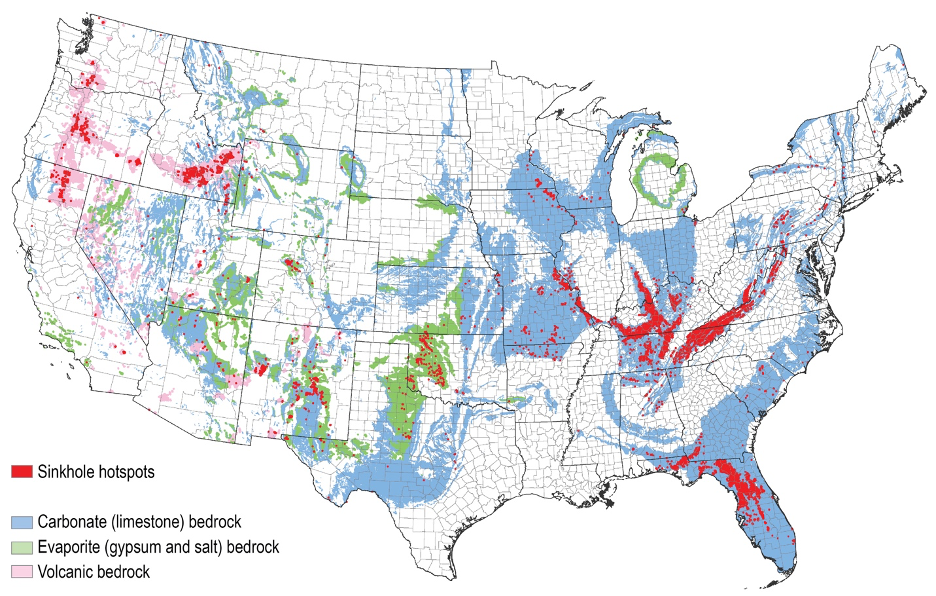
Major Sinkhole Regions and Hotspots
Florida
Florida is one of the world’s best-known sinkhole regions. Much of the state is underlain by limestone, while sand and clay of variable thickness cover the bedrock.
Rainfall, groundwater fluctuations, pumping, construction and the complex shape of the buried limestone surface influence where subsidence occurs. Florida also contains numerous natural sinkhole lakes and karst springs.
Importantly, a reported “subsidence incident” is not automatically a confirmed sinkhole. Professional geological investigation may be required to distinguish karst collapse from pipe leaks, buried debris, organic soil decay and other causes.
Kentucky, Tennessee and the Ozarks
Large parts of Kentucky, Tennessee, Missouri and neighboring states contain extensive limestone karst. Sinkhole plains, caves, sinking streams and springs are major elements of the landscape.
Pennsylvania and the Appalachian region
Carbonate valleys in Pennsylvania and other Appalachian states contain natural sinkholes that can be aggravated by development, drainage changes, quarrying and leaking infrastructure.
Texas and the Wink Sinkholes
West Texas contains natural evaporite deposits and an extensive history of oil, gas and water extraction. The Wink sinkholes are associated with complex interactions among soluble rock, abandoned wells and human alteration of the subsurface.
The Dead Sea
Thousands of collapse features have developed around the Dead Sea as water levels have fallen. Fresh groundwater entering previously submerged salt deposits dissolves the salt and creates underground cavities that later collapse.
These sinkholes have damaged roads, agricultural land, buildings and tourism infrastructure.
China
Southern China contains some of the planet’s most extensive tower-karst and giant-doline landscapes. The region includes immense tiankeng, caves, underground rivers and enclosed depressions.
The Balkans and Dinaric Karst
Slovenia, Croatia, Bosnia and Herzegovina, Montenegro and surrounding areas contain classic karst terrain with dolines, poljes, ponors, caves and powerful springs.
Spain and Mediterranean gypsum karst
Parts of Spain and other Mediterranean countries contain both carbonate and gypsum karst. Urban development over evaporite deposits can create difficult engineering and subsidence problems.
Russia and mining regions
Natural evaporite dissolution and underground mining have produced major collapses in several Russian regions. Some widely shared “sinkholes” are primarily mine-collapse or industrial-subsidence events and should be described accordingly.
Famous Sinkholes and Collapse Events
Xiaozhai Tiankeng, China
Xiaozhai Tiankeng is one of the world’s largest and deepest known giant collapse dolines. It developed above an immense underground river and cave system in carbonate rock.
Its extraordinary scale makes it very different from the small cover-collapse sinkholes that damage roads and homes.
Great Blue Hole, Belize
The Great Blue Hole is a large submarine sinkhole within Lighthouse Reef. It formed as part of a limestone cave system during periods of lower sea level and was later flooded as the ocean rose.
Dean’s Blue Hole, The Bahamas
Dean’s Blue Hole is a deep marine sinkhole surrounded by shallow turquoise water. Like other blue holes, it records the interaction of limestone dissolution, cave development and changing sea levels.
Bayou Corne, Louisiana
The Bayou Corne collapse formed in 2012 above the side of a salt dome after failure associated with an underground storage cavern. The event created a large water-filled depression, released gases and forced the evacuation of nearby residents.
It is often described as a sinkhole, but it was not an ordinary natural limestone doline. It was a complex industrial salt-cavern collapse.
Wink Sinkholes, Texas
The Wink sinkholes opened in an area affected by oil and gas development, abandoned wells, groundwater and soluble evaporite rocks. Their continuing deformation illustrates how industrial activity can interact with naturally vulnerable geology.
Dead Sea sinkholes
The Dead Sea shoreline contains not one isolated hole but extensive fields of collapses. Falling lake levels and the dissolution of underground salt layers have transformed parts of the coast into hazardous terrain.
Guatemala City collapses
The spectacular circular openings that appeared in Guatemala City in 2007 and 2010 are widely called sinkholes. However, they formed in volcanic deposits and were strongly associated with leaking or overwhelmed urban drainage infrastructure.
They are better understood as urban piping and subsurface erosion collapses than classic karst sinkholes.
Berezniki, Russia
Large collapses around Berezniki are connected to underground potash mining and flooding of mine workings. Although frequently labeled giant sinkholes, they belong primarily to the category of mining-related ground collapse and subsidence.
What Is Not a True Sinkhole?
The word “sinkhole” attracts attention, so it is applied to many unrelated ground failures. Correct classification depends on the process beneath the surface.
Collapsed sewer or water main
A broken pipe can wash away surrounding soil until pavement loses support and collapses. The result may look like a sinkhole, but the primary cause is infrastructure failure and underground erosion.
Pothole
A pothole is a pavement defect produced by traffic, water infiltration, freeze-thaw processes and breakdown of the road surface. It does not require a deep underground void.
Abandoned mine collapse
Ground can collapse into underground mines, tunnels, shafts and excavations. These failures should generally be described as mine subsidence or mine collapse unless karst dissolution is also involved.
Construction collapse
Poorly compacted fill, buried waste, improperly closed excavations and failed foundations can create settlement holes unrelated to natural karst.
Earth fissure
An earth fissure is a long crack produced by tension, differential subsidence, fault movement or ground deformation. Unlike a typical sinkhole, it is primarily linear.
Landslide head scarp
A curved crack or depression at the top of a moving slope may mark the beginning of a landslide. Material is moving outward and downslope, not simply dropping into a karst cavity.
Thermokarst depression
Thawing ice-rich permafrost causes the ground to settle, slump and form ponds or craters. Although the landscape may resemble karst, the disappearing material is ground ice rather than soluble rock.
Volcanic crater
Volcanic craters and calderas form through eruptions, explosions, magma withdrawal or collapse into a magma reservoir. They are not sinkholes.
Glacial moulin
A moulin is a vertical shaft in glacier ice through which meltwater descends. It is an ice feature, not a geological sinkhole in bedrock or soil.
Sinkholes vs Subsidence, Fissures and Landslides
| Feature | Typical shape | Main movement | Common cause | Best guide |
|---|---|---|---|---|
| Sinkhole | Closed, circular or irregular depression | Localized downward movement | Dissolution, piping or cavity collapse | Sinkholes Explained |
| Land subsidence | Broad sinking area | Gradual vertical lowering | Aquifer compaction, mining, extraction or natural compaction | Land Subsidence Explained |
| Earth fissure | Long, narrow crack | Extension and differential movement | Subsidence, faulting, drought or slope deformation | Earth Fissures & Ground Cracks |
| Landslide | Scarp, displaced mass and debris | Outward and downslope movement | Gravity acting on an unstable slope | Landslides & Mudslides |
| Thermokarst | Irregular pits, slumps and thaw lakes | Settlement after ice loss | Thawing ice-rich permafrost | Permafrost Collapse & Thermokarst |
Real events can involve more than one mechanism. Subsidence may open fissures; a sinkhole can destabilize a slope; leaking infrastructure can trigger collapse in karst terrain. Classification should reflect the dominant process while acknowledging contributing factors.
Possible Sinkhole Warning Signs
Some sinkholes open without obvious surface warning. Others produce changes that may indicate soil movement, drainage problems or loss of underground support.
Changes in the ground
- A new circular or bowl-shaped depression
- Soft, spongy or unusually wet ground
- Fresh holes that continue enlarging
- Soil disappearing into an opening
- New ponding in an area that previously drained
- Sudden drainage of a pond
- Slumping or cracking around a depression
- Fence posts, trees or utility poles beginning to tilt
Changes in buildings and pavement
- New cracks in foundations, walls or floors
- Doors and windows suddenly sticking
- Floors becoming uneven
- Separations between walls, ceilings or structural elements
- Cracks radiating through driveways or roads
- Localized pavement settlement
Changes involving water
- Unexpected loss of water from a pool or pond
- Cloudy or sediment-filled well water
- Unexplained changes in well levels
- New seepage or flowing water
- Unusually high water bills suggesting a hidden leak
- Persistent sounds of running water underground
These signs are not proof of a sinkhole. Expansive soils, ordinary foundation settlement, leaking pipes, poor drainage and construction defects can produce similar symptoms. A qualified local professional must determine the cause.
What to Do if a Sinkhole Appears
A newly opened hole can expand without warning. The edge may overhang an underground cavity and collapse under the weight of a person, vehicle or machine.
- Stay away from the opening. Do not approach the rim to measure or photograph it.
- Keep children, pets and bystanders away.
- Do not drive or operate heavy equipment nearby.
- Leave an affected building if there is rapid structural movement, cracking, unusual sounds or immediate danger.
- Contact emergency services when people, buildings, roads, utilities or public safety are threatened.
- Report road collapses to local authorities or public works departments.
- Contact utility providers if water, gas, sewer or electrical infrastructure may be involved.
- Document the site only from a safe distance.
- Arrange professional investigation before attempting repairs.
Do not fill a suspicious opening with rocks, concrete, soil or rubbish without understanding where the material is going. An active void can consume the fill, redirect water and enlarge beneath the apparent repair.
How Sinkholes Are Investigated
Sinkhole investigation combines geological evidence, site history, hydrology and subsurface testing. No single technique works perfectly in every setting.
Site inspection
Investigators examine the shape of the depression, cracking patterns, drainage, exposed material, nearby structures and evidence of leaking utilities.
Geological mapping
Bedrock type, soil thickness, known caves, nearby sinkholes, faults, mines and groundwater conditions help establish whether the site is susceptible to karst collapse.
Historical information
Old aerial photographs, construction plans, utility records, mining maps and previous subsidence reports may reveal buried ponds, trenches, wells or excavations.
Ground-penetrating radar
Ground-penetrating radar can identify some shallow disturbances and contrasts in subsurface material. Its effectiveness depends on soil conductivity, moisture, clay content and target depth.
Electrical resistivity
Electrical resistivity imaging measures variations in the electrical properties of the ground. It can help identify cavities, saturated zones, disturbed sediment and irregular bedrock surfaces.
Seismic methods
Seismic refraction, reflection and surface-wave methods infer subsurface structure from the travel of mechanical waves through soil and rock.
Microgravity surveys
Because a cavity or low-density disturbed zone has less mass than intact material, precise gravity measurements can sometimes identify subsurface anomalies.
Drilling and probing
Boreholes, soil sampling and standard penetration tests provide direct evidence, but drilling must be planned carefully to avoid missing narrow cavities or creating new water pathways.
Camera and utility inspection
In urban settings, pipe cameras, leak detection and sewer inspection may reveal that a supposed sinkhole is being generated by failed infrastructure.
Can Sinkholes Be Predicted?
Scientists can identify regions and sites with elevated susceptibility, but predicting the exact location and time of an individual sinkhole remains difficult.
Useful warning and monitoring methods include:
- Repeated land surveys
- Ground deformation measurements
- Satellite radar interferometry
- LiDAR elevation mapping
- Groundwater-level monitoring
- Rainfall and drainage monitoring
- Microgravity surveys
- Electrical and seismic imaging
- Crack gauges and structural sensors
- Inspection of water and sewer networks
InSAR and satellite monitoring
Interferometric synthetic aperture radar, or InSAR, compares radar observations made from satellites at different times. It can reveal subtle ground movement over broad areas.
InSAR is especially useful for regional subsidence and gradual deformation. Detecting a small, rapidly developing cavity beneath vegetation or buildings is more difficult, so satellite data must be combined with ground investigation.
Susceptibility is not certainty
A karst map shows where soluble rocks exist. It does not prove that a cavity lies beneath a specific house, nor can a database guarantee that an unrecorded location is safe.
Reported incident maps also require caution because many depressions are never professionally verified as geological sinkholes.
Sinkhole Prevention and Mitigation
Natural dissolution cannot be stopped across an entire karst region, but many human triggers can be reduced.
Control water carefully
- Repair leaking water and sewer pipes promptly.
- Prevent roof drains from concentrating water beside foundations.
- Maintain stormwater systems and culverts.
- Avoid directing runoff into known depressions without assessment.
- Monitor irrigation and drainage in susceptible terrain.
Manage groundwater extraction
Rapid or excessive pumping can lower groundwater and destabilize cavities or overlying sediment. Groundwater management is therefore an important component of sinkhole-risk reduction in some regions.
Investigate before construction
Large developments in karst terrain may require geological mapping, geotechnical drilling and geophysical surveys. Building layout, foundations, drainage and stormwater systems can then be adapted to site conditions.
Repair methods
The appropriate repair depends on the mechanism, depth, geology, groundwater and structure at risk. Possible methods include:
- Excavating loose material
- Installing graded filters
- Compacted backfilling
- Rock placement
- Pressure grouting
- Compaction grouting
- Deep foundations or underpinning
- Drainage repair
- Pipe replacement
- Long-term monitoring
Improper grouting or indiscriminate filling can block underground drainage and transfer the problem elsewhere. Repairs should therefore be designed for the specific site rather than copied from a generic online diagram.
Common Sinkhole Myths
“Sinkholes appear from nowhere.”
The final opening may be sudden, but dissolution, sediment migration or infrastructure leakage usually began long before the surface collapsed.
“Every circular hole is a natural sinkhole.”
No. Sewer failures, abandoned wells, mine shafts, buried tanks, construction voids and piping collapses can produce similar shapes.
“Every sinkhole has a huge cave underneath it.”
No. Many form as soil progressively moves through relatively small openings in irregular bedrock.
“Heavy rain causes all sinkholes.”
Heavy rain is an important trigger, but groundwater withdrawal, drought, leaking pipes, mining and long-term dissolution can be equally important.
“Sinkholes mean an earthquake is coming.”
There is no general rule linking ordinary sinkhole formation to an impending earthquake. Most sinkholes are hydrological and geological collapse features rather than earthquake precursors.
“A property outside a mapped hotspot cannot develop a sinkhole.”
Regional maps are generalized. Local geology, buried infrastructure, fill, mines and groundwater conditions may not be represented in sufficient detail.
“Once a hole is filled, the problem is solved.”
Not necessarily. If water continues carrying material underground, the fill may disappear and the collapse may recur.
Frequently Asked Questions About Sinkholes
What is the main cause of sinkholes?
Most natural sinkholes form when groundwater dissolves soluble bedrock such as limestone, dolomite, gypsum or salt. Soil and sediment then move into the resulting openings, causing gradual subsidence or sudden collapse.
What is another name for a sinkhole?
Doline is the standard geomorphological term for many enclosed karst depressions. Regional or specialized terms include cenote, swallow hole, swallet, ponor and shakehole, although these words do not always describe exactly the same feature.
What are the three principal types of sinkholes?
The three commonly recognized types are dissolution sinkholes, cover-subsidence sinkholes and cover-collapse sinkholes.
Which sinkhole type is most dangerous?
Cover-collapse sinkholes are generally the most dangerous because a cohesive layer can temporarily conceal an enlarging underground cavity before failing abruptly.
How quickly can a sinkhole form?
The underground processes may operate for years, centuries or longer. Once the remaining roof becomes unstable, however, the visible collapse can occur within minutes or hours.
Why do sinkholes form after heavy rain?
Heavy rain can saturate and add weight to soil, raise groundwater, increase erosion and transport sediment into underground cavities. It often triggers the final collapse of a system that was already weakened.
Can drought cause sinkholes?
Yes. Drought and groundwater pumping can lower the water table and remove support from loose material. Dry soils may also shrink and crack, allowing later storms to penetrate rapidly.
Can earthquakes create sinkholes?
Earthquakes can trigger the collapse of existing cavities or unstable ground, but they are not the primary cause of most sinkholes. Some post-earthquake holes are fissures, liquefaction features or settlement rather than true sinkholes.
Can a sinkhole form under a house?
Yes. Buildings in susceptible karst or evaporite terrain can be affected, especially where groundwater changes, leaking utilities or concentrated drainage accelerate subsurface erosion.
Can sinkholes be predicted?
Geologists can map susceptible terrain and monitor deformation, groundwater and underground anomalies. Predicting the exact time and location of a sudden individual collapse remains difficult.
What is the difference between a sinkhole and land subsidence?
A sinkhole is generally a localized depression associated with material moving into an underground opening. Land subsidence is the broader lowering of the ground surface and may extend across an entire city, valley, delta or groundwater basin.
What is the difference between a sinkhole and an earth fissure?
A sinkhole is usually an enclosed depression produced by downward movement. An earth fissure is a long crack caused by tension, fault movement or differential subsidence.
Are urban road collapses true sinkholes?
Some are, particularly in karst regions. Many others result from broken pipes, failed sewers, washed-out utility trenches or poorly compacted fill and are more accurately described as infrastructure collapses.
Do sinkholes always contain water?
No. Some remain dry, some drain rapidly underground, and others become ponds or lakes where they intersect groundwater or develop a relatively impermeable sediment lining.
What should I do if a sinkhole opens?
Stay away from the opening, keep other people and vehicles clear, leave threatened structures, contact emergency or local authorities when necessary and arrange an investigation by qualified professionals.
Authoritative Sources and Further Reading
- U.S. Geological Survey — Sinkholes
- U.S. Geological Survey — Karst, Sinkholes and Land Subsidence
- U.S. Geological Survey — What Is a Sinkhole?
- U.S. Geological Survey — Land Subsidence
- National Park Service — Karst Landscapes
- Florida Geological Survey — Sinkholes
- Florida Geological Survey — Sinkhole FAQ
Explore Sinkholes & Land Subsidence
- Sinkholes & Land Subsidence — Explore the complete sub-hub covering vertical ground collapse, gradual sinking, surface fissures, disappearing waters and thawing permafrost.
- Land Subsidence Explained — How groundwater withdrawal, mining, oil and gas extraction, sediment compaction and urban development make entire regions sink.
- Earth Fissures & Ground Cracks Explained — Understand giant cracks caused by subsidence, drought, earthquakes, fault rupture, mining and volcanic activity.
- Disappearing Rivers & Lakes Explained — Follow water into swallow holes, ponors, underground rivers and mysterious lakes that drain through karst systems.
- Permafrost Collapse & Thermokarst Explained — Explore thaw slumps, collapsing tundra, Arctic craters and landscapes reshaped by melting ground ice.
