There is a major storm expected to hit the Northeast on Thursday, Jan. 4. Bomb cyclone Grayson is rapidly intensifying, with atmospheric pressure expected to drop 47 mb in less than 24 hours, and getting as low as 950 millibars. In comparison, winter storms ‘Nemo’ and ‘Stella’ had pressures around 970 millibar. This extreme ‘bombogenesis’ will produce heavy snow, blizzard conditions, high-speed winds and coastal flooding. Winter storm Grayson is expected to cause Hurricane Sandy level damage. And here it comes:
Visible loop from @CODMeteorology of our powerful matured nor’easter!
Visible loop from @CODMeteorology of our powerful matured nor’easter!#FrozenAmerica pic.twitter.com/kdOSWqjpIn
— Jim Cantore (@JimCantore) 4 janvier 2018
Blizzards storm surge in Massachusetts, USA on January 4, 2018:
Wow you’d think this was the scene from a zombie apocalypse movie. This was taken in Wegmans in Chestnut Hill, Boston in anticipation of tomorrow’s Bomb Cyclone Grayson – Image credit to Kelly Mullan:


Hurricane force wind warnings from MA up the ME coast. Some tweaks to Blizzard warnings as well putting more in bliz warnings:
Hurricane force wind warnings from MA up the ME coast. Some tweaks to Blizzard warnings as well putting more in bliz warnings. pic.twitter.com/iJaNzm8qSI
— Jim Cantore (@JimCantore) 4 janvier 2018
This is about as text book as is gets:
This is about as text book as is gets. pic.twitter.com/T01GiXJFJl
— Jim Cantore (@JimCantore) 4 janvier 2018
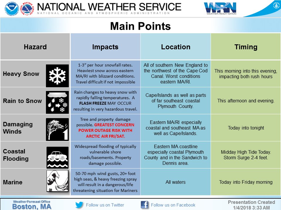
Overview of hazards from today’s major winter storm: Heavy snow, high winds, moderate to major coastal flooding:
Powerful nor’easter in the making:
Powerful nor’easter in the making. pic.twitter.com/6aA8q1E2qZ
— Jim Cantore (@JimCantore) 4 janvier 2018
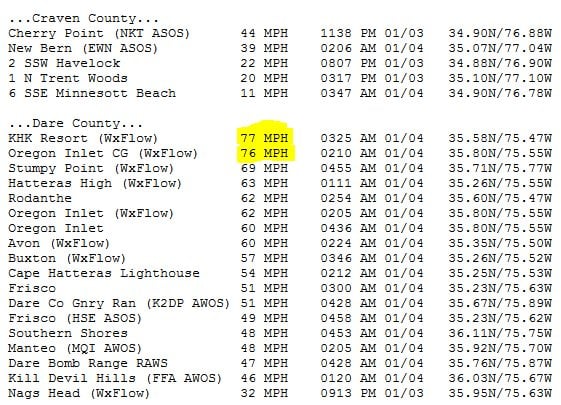
Gusts over hurricane force measured along the coast of North Carolina:
Check out the gravity waves emanating from the Bomb Cyclone Grayson off the Carolina coast from GOES16 infrared imagery:
Gravity waves propagating outward from deep convection associated with a #BombCyclone off the Carolina coast. @NOAA #GOES16 infrared imagery. pic.twitter.com/sxPfIih8OT
— NASA SPoRT (@NASA_SPoRT) 4 janvier 2018
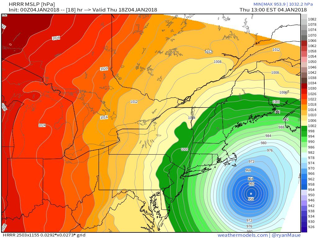
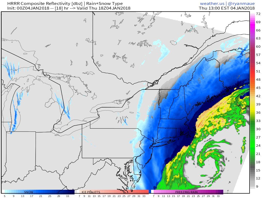
Based on HRRR 18-hr forecast of 954 mb … 47 mb / 24 hours … would be the deepening rate (38 mb / 18 hrs) of the blizzard/Nor’easter/bomb cyclone/extratropical storm/winter storm/Grayson/snowstorm/storm:
Look at the truly spectacular piece of energy arriving and amping up the low:
Let the GOES games begin! Truly spectacular to watch the piece of energy arrive and amp up the low. #BomboNumber5 pic.twitter.com/CfRf1DJSHv
— Matt Reagan (@ReaganMatt) 3 janvier 2018
Here first pictures and videos of the powerful winter storm Grayson. One thing is sure: There will be blood!


