Record floodwaters that submerged vast stretches of Nebraska and Iowa farmland along America’s longest river reached a new crest on Friday at the waterfront city of St. Joseph, Missouri, forcing chaotic evacuations of thousands from low-lying areas. With emergency sirens blaring as the Missouri River rose to the top of the three-story-high levee wall in St. Joseph, about 55 miles (88 km) north of Kansas City, Missouri, sheriff’s deputies rushed door-to-door urging residents to flee to higher ground.
About 1,500 residents and some 6,000 employees of nearby businesses were ushered out of the southern end of town. Most of the evacuated dwellings consisted of trailer homes interspersed among industrial plants, warehouses and a stockyard along a stretch of the riverfront known as “the Bottoms.”
Many residents appeared stunned as they scurried out of their homes with armloads of hurriedly gathered belongings to throw into their vehicles before joining a steady stream of cars, pickup trucks, SUVs and tractor-trailers.
Missouri River flooding forces evacuation of 7,500 from St. Joseph https://t.co/EV47kwJp3R pic.twitter.com/VggsGAOKU9
— St. Louis Post-Dispatch (@stltoday) March 23, 2019
The abrupt evacuation, coming as the river rose about 9 feet above flood stage, appeared to take authorities and residents by surprise.
“We don’t have anywhere to go. This is overwhelming,” said Linda Roberts, 70, as she and her husband, John, 66, packed their SUV, their dog sitting uneasily in a pet carrier.
Flash Flood Warning in the St Joseph, Missouri area until 8:15 AM CDT Friday, March 22. River crest forecast of 31.5 feet indicate a levee on the Missouri river will overtop causing flash flooding of the area. pic.twitter.com/dioqIUhvtA
— NWS MBRFC (@NWSMBRFC) March 22, 2019
With police doing their best to direct gridlocked traffic and with helicopters whirring overhead, dust billowed up from packed roadways for hours, mixed with the odors of livestock and chemicals, as the mass exodus proceeded in slow motion.
CRESTING IN KANSAS CITY
The St. Jo Frontier Casino, about 5 miles to the north, was already surrounded by water, and roadways along the river were submerged, officials said.
The flood crest was expected to reach the Kansas towns of Atchison and Leavenworth, about 35 miles farther downstream, on Saturday, and Kansas City as early as Sunday, officials said.
**FLOODING IN THE MIDWEST** River levels continue to rise across Missouri as temperatures climb both overnight and during the day. Pay attention to any evacuation notices issued for communities who might be impacted! #mowx pic.twitter.com/go2duEJ5L2
— WeatherNation (@WeatherNation) March 22, 2019
Missouri River flooding was triggered by last week’s “bomb cyclone” storm, which has killed at least four people in Nebraska and Iowa, left a man missing below Nebraska’s collapsed Spencer Dam, and inflicted an estimated $1.5 billion in damages in Nebraska.
Torrential showers over hundreds of square miles of melting snowpack produced record volumes of runoff that poured into the Missouri just above the Gavins Point Dam where the river divides Nebraska from South Dakota, nearly 400 miles upstream from Kansas City. The dam is operated by the U.S. Army Corps of Engineers.
Portage des Sioux, MIssouri – My River Home & Sioux Harbor flooding. #flood19 #missouriflood #mississippiriver #flood2019 pic.twitter.com/JXEVWIKzyF
— sherry doster (@sherrydoster) March 23, 2019
Water entering the reservoir from that storm marked the most ever measured there since recordkeeping began 120 years ago, said John Remus, chief water manager for the Army Corps’ Missouri River basin. The downstream flow also broke flood stage records at three locations along the river.
Nebraska farmers were digging out of flooded fields and coping with cut-off highways on Friday.
“The biggest thing right now is the transportation. We’re right between Loup and Cedar River, and transportation is nearly impossible,” said Ryan Sonderup, 36, of Fullerton, Nebraska, who has been farming for 18 years.
FLOODING EMERGENCY: The Missouri and Mississippi Rivers are overflowing across several states as more rain slam the Midwest this weekend, with the record flooding expected to last into next week. @RobMarciano with the forecast. https://t.co/S78Rc3eprR pic.twitter.com/b3kbH9dI5x
— World News Tonight (@ABCWorldNews) March 24, 2019
DISASTER DECLARATIONS
Officials in Atchison, Kansas, were watching flood monitors carefully on Friday.
“For the most part, the city of Atchison is much more fortunate than some of the other communities along the Missouri River,” the city’s assistant manager, Justin Pregont, told Reuters. Still, floodwaters were threatening a handful of properties and roads along the riverfront in the community of 10,000, he said.
Missouri Governor Mike Parson declared an emergency on Wednesday as high water forced evacuations of several small farm communities in the northwestern corner of his state.
Flooding across the Midwest this week has claimed three lives, damaged thousands of homes, and busted about 20 levees in Nebraska, Iowa, and Missouri. President Donald Trump on Thursday approved Nebraska's request for federal disaster assistance. https://t.co/dlgldpsVo4
— CS Monitor (@csmonitor) March 22, 2019
President Donald Trump on Thursday approved a disaster declaration for Nebraska, making federal funding available in nine counties that had born the brunt of last week’s floods.
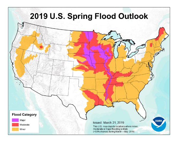
The threat of extensive flooding lingers over the wider region and could grow dire in coming weeks with additional rainfall and melting snow runoff, the National Oceanic and Atmospheric Administration (NOAA) said on Thursday.
NOAA spokeswoman Lauren Gaches said during a conference call Thursday that existing flooding along the Mississippi River and other waterways is expected to get worse, possibly even worse than historic floods in 1993 and 2011.
“This is shaping up to be a potentially unprecedented flood season, with more than 200 million people at risk,” Ed Clark, director of NOAA’s National Water Center in Tuscaloosa, Alabama, said in the agency’s spring outlook.
@NOAA Spring outlook for flooding puts much of the region along the Missouri River in the potential area for more moderate to major flooding. @kmbc #kcwx pic.twitter.com/qNx5U9RHmV
— Neville Miller KMBC (@NevilleKMBC) March 21, 2019
NOAA said in an advisory that the threat of flooding in Southern states this spring is “potentially historic.“
Get prepared and be ready for the upcoming flooding!?!


