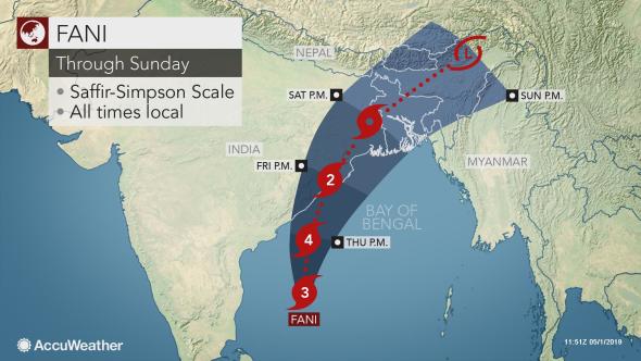
Cyclone Fani continues to strengthen as it tracks over the Bay of Bengal and may make a direct hit on the eastern India coastline later this week. More than 100 million people are in the potential path of this life-threatening tropical cyclone. Fani is currently an Extremely Severe Cyclonic Storm with winds equal to a Category 3 hurricane in the Atlantic or East Pacific oceans.

Additional strengthening is expected into Thursday as Fani could bring winds in excess of 213 km/h (132 mph), equal to a Category 4 hurricane.
There is a chance that Fani could briefly become a Super Cyclonic Storm, equivalent to a Category 5 hurricane, during this time.
#Cyclone #Fani has intensified and how has maximum winds of 105 mph – the strongest cyclone this early in the calendar year in the North Indian Ocean since Cyclone Nargis in 2008. pic.twitter.com/yW9hspzumi
— Philip Klotzbach (@philklotzbach) April 30, 2019
Fani is expected to remain a powerful and dangerous cyclone as it approaches and makes landfall along the coast of eastern India between Thursday night and midday Friday.
Residents from northern Andhra Pradesh to Odisha, Jharkhand, West Bengal and Bihar are at risk for impacts from the approaching cyclone.

Areas along the coast, such as Kakinda and Visakhapatnam, to the border with Bangladesh will have to deal with rough seas and varying levels of coastal flooding.
May Lord Jagannath save Odisha from cyclone "FANI"
— Chowkidar Sulagna Dash?? (@SulagnaDash6) May 1, 2019
??? pic.twitter.com/D0GtKLZcrL
In advance Fani’s arrival, operations at Paradip Port in Odisha were suspended beginning on Wednesday night.
East Coast Railway has canceled 74 trains in the coming days due to the expected poor weather due to Cyclone Fani.
#CycloneFani : Indian Air Force stands ready to provide assistance to the people of Odisha, Andhra Pradesh & Tamil Nadu in the advent of Cyclone Fani. pic.twitter.com/0Qx8ePjLEy
— Indian Air Force (@IAF_MCC) April 29, 2019
Cities from Brahmapur to Puri could be dealt a direct hit with impacts ranging from destructive winds to flooding downpours and an inundating coastal storm surge.
Locations near and just east of where landfall occurs can experience wind gusts in excess of 210 km/h (130 mph) that could result in widespread damage to all structures.

As Fani tracks inland Friday night into Saturday it will weaken, lowering the risk for damaging winds across Jharkhand, Bihar and West Bengal; however, locally damaging winds and flooding rainfall will still be possible.
While Fani will begin weakening prior to reaching Kolkata, downpours and damaging winds will be possible from Friday afternoon into Saturday.

From Saturday night into Sunday, Fani will weaken into a tropical rainstorm as it tracks over Bangladesh and northeast India.
#Odisha – Be Prepared | Be Safe#FANI (pronounced as Foni) #Cyclone #NDMA #OSDMA #DRR #DisasterPreparedness #DisasterResilientIndia pic.twitter.com/vLsSaBdp7V
— Munmun Dasmohapatra (@MunmunDasmohap1) May 1, 2019
Hope people in the mentioned areas were able to prepare for that next damaging storm.


