A severe derecho rocked the upper Midwest on Friday evening, July 19, 2019 with baseball-sized hail damaging several cars north of Minneapolis.
Thousands were without power in northwestern Wisconsin. Nearly a quarter million homes remained without power early Saturday morning.
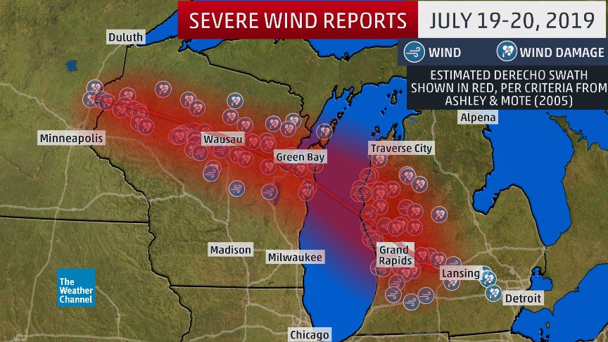
Soaring temperatures gave way to severe storms Friday evening in the upper Midwest, packing powerful winds that knocked out power to hundreds of thousands and hail as big as baseballs that left numerous cars damaged along a Minnesota interstate.
As the line of severe storms known as a derecho moved into Michigan, hundreds of thousands lost power. As of early Saturday morning, more than 225,000 homes and businesses remained without power, according to PowerOutage. Later in the morning, outages came down to 162,000.
WOW! This is insane! Look at this storm developping:
Before pushing into Michigan, the Derecho brought strong winds that downed trees and knocked out power to much of Burnett County, according to PowerOutage.us. In northwestern Wisconsin, more than 42,000 homes and businesses were without power Friday night.
Turtle Lake, Wisconsin, about 55 miles northeast of St. Paul, was particularly hard hit. A roof was ripped off one business, and siding was partially torn from a hotel.
An EF1 tornado that was on the ground for nine miles damaged a barn, hundreds of trees and tore the roofs of several building in Marathon County, the National Weather Service reported.
Widespread tree damage has been reported across Langlade, Shawano, Portage, Outagamie, Kewaunee and Manitowoc Counties in eastern Wisconsin.
If the wind wasn’t bad enough, a tornado touched down near Knowlton, Wisconsin, located roughly 50-55 miles west-northwest of Green Bay around 8:30 p.m. CDT, destroying a barn.
Trees were downed in Green Bay as the line of thunderstorms arrived late Friday evening.
Some 60 miles north of Minneapolis, several vehicles sustained window damage when large hailstones were dropped on Interstate 35 near Pine City. Another motorist reported similar hail damage a few miles south, near Rock Creek.
US stay strong! No injuries were immediately reported in Minnesota in the wake of the storms.
An insane hailstorm during a very strong Derecho across upper Midwest. Be prepared for the next one!


 in 3 days of storm")


