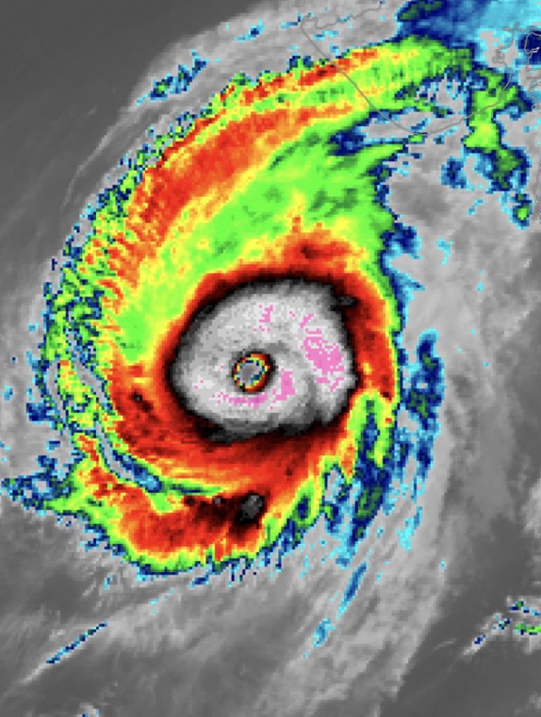
The northern hemisphere’s quietest tropical cyclone basin is currently going off.
Cyclone Kyarr formed on Thursday and quickly spun up in the Indian Ocean into the most powerful storm on the planet.

Rains, winds and storm surges from the Arabian Sea’s strongest cyclone in a decade hit Oman’s south coast on Tuesday morning.
Efect of cyclone kyarr @ muttrah corniche #muscat #oman #KyarrCyclone @muscat_daily @OmanObserver @timesofoman pic.twitter.com/xkY7lwpzlB
— satuuuu (@KariaSatyen) October 29, 2019
Cyclone Kyarr rapidly intensified over the weekend, going from the equivalent of a Category 2 to Category 4 storm in just six hours on Saturday.
Then for a few hours it reached Category 5:
SPECIAL ADVISORY. Super Cyclone #04A #Kyarr has continued to rapidly intensify, and has now became only the second Category 5 on record in the Arabian Sea. Maximum sustained winds have increased to 160mph, minimum central pressure has decreased to 928mb. #Category5 pic.twitter.com/lFOXHJZzo0
— World Cyclone Warning Center (@warning_center) October 27, 2019
During its rapid intensification, Kyarr’s pressure bombed out to 915 millibars. And this reading set a new record for Arabian Sea cyclones. The all-time low pressure record for the basin was set by another cyclone back in 1999.
Super Cyclonic Storm #Kyarr has the lowest pressure on record in the Arabian Sea, with a central pressure of just 915hPa.
— Met Office (@metoffice) October 27, 2019
Estimated winds are joint strongest on record, alongside Cyclone #Gonu pic.twitter.com/JPBwQ77yh7
It’s also the first such system to form in the Arabian Sea since June 2007’s Cyclone Gonu, which made landfall in the Middle East.
Super Cyclonic Storm #Kyarr has the lowest pressure on record in the Arabian Sea, with a central pressure of just 915hPa.
— Met Office (@metoffice) October 27, 2019
Estimated winds are joint strongest on record, alongside Cyclone #Gonu pic.twitter.com/JPBwQ77yh7
The super cyclonic storm is currently packing winds of around 150 mph.
#SuperCyclonicStormKyarr becomes one of the strongest cyclones ever in the #ArabicSea (the single strongest by #IMD, second strongest by #JTWC), reaching a peak intensity of 135knots! Kyarr is forecasted to gradually weaken and hit Somalia in the next few days.#CUSciStory pic.twitter.com/NHyBhbvqDm
— Kinen Luigi Kao (@kinenluigikao) October 29, 2019
Kyarr Will Have No Major Impacts On Land
The good news is that Kyarr is well out to sea.
The storm is pointed toward Oman, but it’s expected to turn southwest and then track parallel to the coast.
Things are getting scary /worse in OMAN ,the water start entering houses ” Pray For OMAN and its People hope everything goes well AMEEN #CycloneKyarr #kyarr #OMAN pic.twitter.com/ImGAZsswPi
— Mariam Jamali ?? (@Mariam_Jamali) October 28, 2019
Still, rains, winds and storm surges from the Arabian Sea’s strongest cyclone in a decade hit Oman’s south coast on Tuesday morning.
Muttrah in #Muscat ??is on the edge of the impact from Cyclone Kyarr as rough Sea of Oman floods onto the Corniche pic.twitter.com/3ekbs9NBIH
— TonyWalsh?توني والش (@TonyWalsh_me) October 29, 2019
Along the way, it will slowly begin to weaken.
Efect of cyclone kyarr @ muttrah corniche #muscat #oman #KyarrCyclone @muscat_daily @OmanObserver @timesofoman pic.twitter.com/xkY7lwpzlB
— satuuuu (@KariaSatyen) October 29, 2019
Early next week, it could potentially bring impacts to the Horn of Africa, but it’s still way too early to talk about what they could look like.
humans and common sense #Kyarr #اعصار_كيار pic.twitter.com/PYVET9hx65
— clown ninja a keeper (@UmaisArif) October 29, 2019
Most Intense Cyclone Season On Record In The Indian Ocean
Beyond individual superlatives, Kyarr also pushed the Indian Ocean to set a record for its most intense cyclone season on record. Scientists use a metric known as accumulated cyclone energy (ACE) to take a big picture view of cyclone seasons.
ACE essentially adds up the windspeed measurements from all storms in the basin over time, giving a clearer metric than just the number of storms of how intense a season was.
With Cyclone #Kyarr being on the cusp of becoming a category 5 hurricane, it’s producing a ton of Accumulated Cyclone Energy (ACE), making this North Indian Ocean hurricane season the most active on record. The ongoing extreme +IOD event probably deserves a lot of blame for this. pic.twitter.com/XjSrb6dt7O
— Eric Webb (@webberweather) October 27, 2019
In the case of the Indian Ocean, ACE is up to 53.9 or more than five times the normal ACE for this time of year.
It also represents a record for the most intense Indian Ocean cyclone season on record.
The basin is usually sleepier than the Atlantic and parts of the Pacific, but the strong Positive Indian Ocean Dipole currently going on, a natural climate pattern, has given a boost to tropical cyclones in the western portion of the basin this year. [TheNational, Gizmodo]


