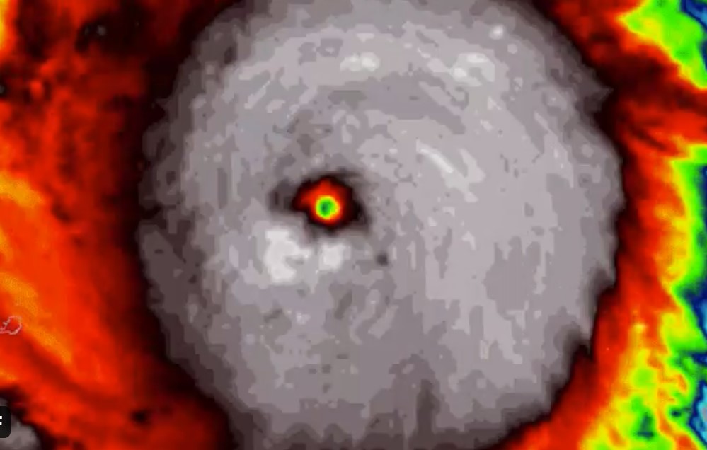
Hurricane Eta has rapidly intensified into a Category 4 hurricane as it heads toward a potentially catastrophic landfall in Nicaragua Tuesday.
Eta just intensified from 35kt to a 115kt cat-4 in 36 hours. Only ONE storm was stronger after 36 hours … You remember Hurricane Delta?
Okay this is something …
— Sam Lillo (@splillo) November 2, 2020
Eta just intensified from 35kt to a 115kt cat-4 in 36 hours.
Let's look at all Atlantic TCs *any time of the year* starting at 35kt or lower.
I did this and saw only ONE storm that was stronger at 36 hours ….. Remember Hurricane Delta? pic.twitter.com/Ov7P8XvPbg
As of the National Hurricane Center’s 4 p.m. EST advisory Monday, Eta had maximum sustained winds of 130 mph, a Category 4 hurricane on the Saffir-Simpson hurricane wind scale. Some additional strengthening is possible before landfall.
Yet another #RapidIntensification oh my ? and out pops that eye ?️ #Eta #2020ing pic.twitter.com/N0DEvqTk5Z
— Stu Ostro (@StuOstro) November 2, 2020
Eta is forecast to bring a catastrophic storm surge and destructive winds to the northeast Nicaraguan coast near the storm’s eyewall Tuesday. Eta’s slow movement through the rest of the week is likely to bring catastrophic flash flooding and mudslides from heavy rain well inland over Central America.
JUST IN: #HurricaneEta continues to rapidly intensify, now a Cat 4. Could even come close to Cat 5 before devastating landfall in Nicaragua tonight/Tuesday. Eta has strengthened faster than any storm on record in the Atlantic during November.
— Capital Weather Gang (@capitalweather) November 2, 2020
Update: https://t.co/rM59mfWlQ6 pic.twitter.com/oahBHw23Wc
Eta became only the fourth November hurricane to reach Category 4 intensity in historical records dating to 1851, according to Colorado State University tropical scientist Phil Klotzbach. Paloma in 2008 was the last hurricane to do so.
#Eta forecast to become a Category 4 #hurricane before landfall in Nicaragua. There have been 3 Category 4s and 1 Category 5 in the Atlantic in November on record:
— Philip Klotzbach (@philklotzbach) November 2, 2020
Category 4:
Lenny (1999)
Michelle (2001)
Paloma (2008)
Category 5:
Cuba Hurricane (1932) pic.twitter.com/xwudBvIrkT
More news on Hurricane Eta on weather.com, Strange Sounds and Steve Quayle.


Get the skiffs ready, or kayaks. Patrol the flooded areas, and rescue the people. Animals too.
Tuesday November 3 2020, 08:18:56 UTC 267 km WNW of Haveluloto, Tonga 5.7 388.0 USGS Feed Detail
Tuesday November 3 2020, 08:18:56 UTC 267 km WNW of Haveluloto, Tonga 5.7 388.0 USGS Feed Detail
Tuesday November 3 2020, 08:04:24 UTC 26km SSW of Ocotillo Wells, CA 0.9 6.6 USGS Feed Detail
Tuesday November 3 2020, 08:03:44 UTC Balleny Islands region 4.7 36.0 USGS Feed Detail
uesday November 3 2020, 05:24:33 UTC 218 km SE of Kokopo, Papua New Guinea 4.8 10.0 USGS Feed Detail
Tuesday November 3 2020, 05:20:40 UTC 17km ESE of Anza, CA 0.9 13.0 USGS Feed Detail
Tuesday November 3 2020, 05:06:02 UTC 26 km SSE of Mina, Nevada 0.9 6.1 USGS Feed Detail
Tuesday November 3 2020, 05:03:28 UTC 24 km S of Mina, Nevada 0.6 0.1 USGS Feed Detail
Tuesday November 3 2020, 04:54:11 UTC 41km NE of Covelo, CA 2.2 4.0 USGS Feed Detail
Tuesday November 3 2020, 04:51:44 UTC 34 km SE of Mina, Nevada 1.0 8.6 USGS Feed Detail
Tuesday November 3 2020, 04:45:05 UTC 23 km SW of Petersville, Alaska 2.2 75.6 USGS Feed Detail
Tuesday November 3 2020, 04:35:55 UTC Banda Sea 4.5 105.0 USGS Feed Detail