Just a week after the first bomb cyclone hit New England, it’s now time to “batten down the hatches” ahead of the biggest snow and ice storm of the season for the Northeast.
The blockbuster storm will unfold from Tuesday to Thursday and unload more than 2 feet of snow in spots and up to 30 inches expected.
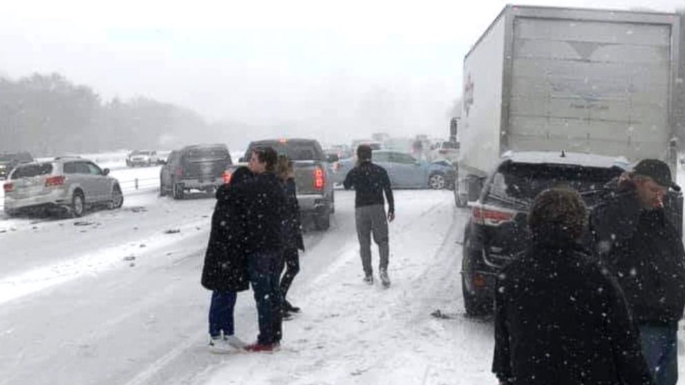
The sizable storm has a wide coverage area, with snow expected to fall from southern Illinois to Atlantic Canada and target major thoroughfares including Interstate 95.
Record Snow (north) and dangerous ice (south)
Winter storm watches and advisories have been issued across the Northeast for what is shaping up to be the most significant winter storm in several years.
The major midweek storm is set to unleash a foot of snow or more across parts of the central Appalachians, upper mid-Atlantic and southern New England.
In addition, parts of the interior South is expected to get a thick glaze of ice as a drenching rain will pour down along the lower mid-Atlantic coast.
Major snowstorm in the Northeast
Forecasters are warning of major disruptions to travel and even travel shutdowns, as well as shipping delays, school closings and power outages from this blockbuster storm.
Some areas may not only pick up the heaviest snowfall in several years, but this snow could also rival December snowfall records.

A broad swath of 12-18 inches of snow is projected to fall from northwestern Virginia and northeastern West Virginia to part of northern Maryland, south-central and eastern Pennsylvania, northern New Jersey, southeastern New York state and southern New England.
Within this area, some places can pick up a 24-inch snowfall amount with an AccuWeather Local StormMax™ of 30 inches.

Snowfall of this magnitude has the potential to shut down travel and lead to major delays of shipments at a time when a critical distribution of COVID-19 vaccines has begun.
Blizzard conditions along the coast
The combination of heavy snow and gusty winds can create near-blizzard conditions just inland of the coast where all or mostly snow falls from the storm.
Northern New Jersey and the lower Hudson Valley of New York state through southern New England is the most likely zone to experience near-blizzard and whiteout conditions.
In this area, winds can frequently gust between 40 and 50 mph, dropping the visibility to near-zero at times at the height of the storm Wednesday night into Thursday morning.

There is the likelihood of power outages and even minor tidal flooding due to strong winds at the coast.
The snowstorm forecast
The storm is forecast to begin over parts of the Ohio Valley and the southern Appalachians during Tuesday night and spread across the central Appalachians and mid-Atlantic during the day Wednesday.
The storm’s impacts will reach southern New England on Wednesday evening.

Heavy snow is forecast to fall on Boston; Providence, Rhode Island; Hartford, Connecticut; Scranton, Allentown, Reading, Harrisburg and State College, Pennsylvania; Paterson, New Jersey; Middletown, New York; Hagerstown, Maryland; and Martinsburg, West Virginia.
A foot of snow could bury all of these locations with major disruptions to travel and daily activities.
But, even in New York City, Philadelphia, Baltimore and Washington, D.C., anywhere from a couple of inches of slushy snow to several inches will pile up.
Snow is expected to become mixed with and change to sleet and rain at the height of the storm — and the timing of the changeover will play a big role in totals.
Snowfall accumulation will increase dramatically from southeast of I-95 to the metro areas and northern and western suburbs.

Exactly how much snow falls along the Interstate 95 corridor in the mid-Atlantic is highly dependent on the exact track of the storm, according to AccuWeather Senior Meteorologist Courtney Travis.
“A shift farther to the east or west by 25 miles can have a huge impact on accumulation of snow versus more mixing of rain and snow and plain rain,” Travis said, adding that an altered storm track could also make a big difference in snow amounts on the western side of the storm.
Snow totals could change from an inch of snow to 6 inches or a foot of snow, since there will be a sharp edge to the snowfall on the storm’s northern and western fringe.

Dangerous ice in the south
Farther south, a swath of ice is forecast to cover surfaces in parts of western North Carolina, upstate South Carolina, southwestern and central Virginia and part of central Maryland from last Tuesday night to Wednesday.
A glaze of ice of 0.10 to 0.25 of an inch is projected.

“Significant power outages will be possible in the area where ice totals of 0.25 of an inch occur, but where mostly sleet falls — with the tendency to bounce off elevated surfaces — the risk of power outages will be lower,” according to AccuWeather Meteorologist Jake Sojda.
Amid the ice storm, which will happen along stretches of I-40, I-77 and I-81, roads can become extremely slippery, and travel should be avoided.
Storm end: Thursday
The storm should last no more than 24 hours in most locations and is likely to last a mere 12 hours in some locations.
The wintry precipitation is forecast to end Wednesday afternoon and evening over parts of the Ohio Valley and southern Appalachians, Thursday morning and midday in the mid-Atlantic and central Appalachians and finally taper off during Thursday afternoon and evening in New England.

A major snowstorm is not expected over the Ohio Valley, but snowfall on the order of 1-3 inches will make roads slippery in parts of southern Illinois, southern and central Indiana, much of Ohio and western West Virginia.
The blockbuster storm has already begun to drop snow over parts of the interior West and is forecast to spread accumulating snow over the southern Plains into Monday night and Tuesday.
The most powerful snowstorm to hit the Northeast in years could potentially become highly impactful and disruptive as the first round of coronavirus vaccines continue to be shipped around the country.


 in 3 days of storm")


Well this is nothing , Snow is part of nature and i remember Montana to Wi got 50 inches few years back. So this is just starting indeed. I love snow a lot ,less disease
due no diseases can survive -30 C . Global ice age is closer tham global warming what do you think?
Let’s have a big round of applause for Golbull Warming.
Old Frosty the Snowman is blessing the lefties with some weiner frostbite.