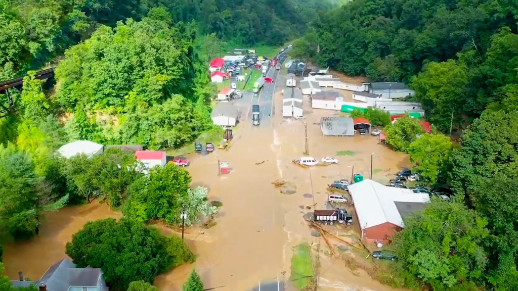
2 dead, 10 to 15 bridges in Haywood County have been damaged or destroyed and as many as 35 people are reported missing or unaccounted for after flash floods in North Carolina brought by torrential rainfall from Tropical Storm ‘Fred’. Meanwhile two people have been confirmed dead in western North Carolina.
Related: Watch the new trailer about megadrought and vanishing water…
Governor Roy Cooper issued a State of Emergency on 18 August to activate the state’s emergency operations plan. In his statement, the governor said nearly a foot of rain (300 mm) has fallen over the past three days in some areas of Western North Carolina from the remnants of Tropical Storm Fred and the rains that preceded it, and record flooding is occurring.
More than 98 people have been rescued from floodwaters in western counties.
“This state of emergency will allow our first responders to get into our affected communities quickly to save lives, restore power, remove debris and bring supplies,” said Governor Cooper. “North Carolina is strong and resilient, and we’re committed to helping people and businesses recover as quickly as possible.”
Floods in Haywood County, North Carolina
Haywood County appears to be the most severely impacted, where historic flooding is happening along the Pigeon River.
In a statement of 18 August the Emergency Services Department said “at this time we have around 35 people still unaccounted for. Several people were located safe and reunited with their families, and several others were added to the list throughout the day as loved ones called in.”
Water systems in the towns of Canton and Clyde have been impacted and boil water advisories are in effect. There is significant damage to roads and bridges, especially in Cruso, with at least 10-15 bridges damaged or destroyed. Ten people had taken refuge in an emergency shelter in a school building in Waynesville.
8 North Carolina counties affected
As well as Haywood, other affected counties include Jackson, McDowell, Madison, Mitchell, Rutherford, Transylvania and Yancey which have all declared local states of emergency. Utility companies are working to restore power after outages peaked at about 50,000 customers late 17 August.
North Carolina Emergency Management has deployed swift water rescue teams from across the state to Western North Carolina, and National Guard and Highway Patrol helicopter crews are conducting searches. More than 250 responders from across the state are involved in the search and rescue effort.
Rain and Rivers
Heavy rain was reported in the area before Fred – which had been downgraded to a depression – had reached North Carolina.
In a 24 hour period to 15 August, the weather station on Mount Mitchell, the highest peak of the Appalachian Mountains, recorded 1.31 inches (33.27 mm) of rain. In the following 24 hour period Waynesville in Haywood County recorded 1.7 inches (43.18 mm). Boone in Watauga County recorded 1.68 inches (42.67 mm) in 24 hours to 17 August.

The heaviest rain fell in a 24 hour period from 17 to 18 August. The weather station at Beech Mountain recorded 4.60 inches (116.84mm); Boone 5.10″ (129.54 mm); Bryson City 3.06″ (77.72 mm); Highlands 4.55″ (115.57 mm); Jefferson 3.95″ (100.33 mm); Murphy 4.90″ (124.46 mm) and Waynesville 3.17″ (80.51 mm).

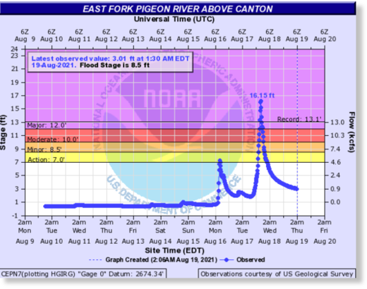
The East Fork Pigeon River above Canton in Haywood County reached a record high of 16.15 feet late on 17 August, above Major Flood Stage of 12 feet and beating the previous record high of 13.1 feet.
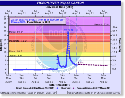
The Pigeon River at Canton peaked at 19.76 feet late on 17 August, above Major Flood Stage of 19 feet.
Florida and Georgia
Tropical Storm Fred previously swept through the Florida panhandle on 16 August, bringing heavy rainfall, flooding and strong winds.
One death was reported after a car hydroplaned near Panama City, the Florida Highway Patrol said. Evacuations were carried out after flooding in Lynn Haven.
Heavy rain drenched parts of metro Atlanta, Georgia, early on 17 August causing traffic problems for the morning commute.
As many as 14 possible tornadoes were reported across Georgia, South Carolina and North Carolina, according to the National Weather Service. [Floodlist]
Does deadly flooding on one side of the country mean unprecedented megadrought on the other side? Watch this new trailer about the current megadrought and its implication on food, economy and society:
Now subscribe to this blog to get more amazing news curated just for you right in your inbox on a daily basis (here an example of our new newsletter).
You can also follow us on Facebook and/ or Twitter. And, by the way you can also make a donation through Paypal. Thank you!
You should really subscribe to QFiles. You will get very interesting information about strange events around the world.


Beautiful area, but looks like a low lying spot where the water flooded on that road. That is why I picked high ground. We had flash flooding, and all the low lying areas got swamped.
Of course, some of our local inbred retards tried to drive through, and got stuck —pulling rescue worker’s attention to help. That means they were shorthanded for other emergencies.
Don’t be an idiot when severe flash flood warning hit your cell phone or emergency broadcast on radio. Better to be safe than sorry.