The remnants of an unrelenting Hurricane Ida took aim at the northeastern U.S. on Wednesday as the potential for life-threatening and damaging flooding stretched into New England.
More than 50 million people in the Northeast alone were under a flash flood watch or warning, four days after Ida roared ashore in Louisiana as a Category 4 hurricane. The winds had vastly diminished, but the storm was dishing out heavy rain, much of it in areas already saturated by recent deluges.
“Many areas along the path of Ida are likely to have rounds of rain over a 12- to 18-hour period, but intense rainfall can last six to eight hours,” AccuWeather Senior Meteorologist Dan Pydynowski warned.
So what’s really going on?
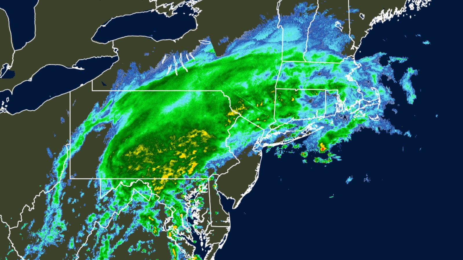
The unusual high-risk area for extreme rainfall and flash flooding covered much of the Northeast U.S. on Wednesday as the remnants of Hurricane Ida joined forces with a frontal zone.
Ida was declared post-tropical as of 11 a.m. EDT Wednesday, September 1, but the remnant surface low is actually expected to strengthen as it moves from western Virginia to the Northeast coast by Wednesday night.
Ex-Ida will merge with a stationary front beneath a strong jet stream, a set of factors that will lead to widespread dangerous weather from Wednesday into early Thursday, including torrential downpours and the chance of tornadic supercells.
So what can you expect?
At midday Wednesday, heavy rains had already engulfed much of Pennsylvania, northern Virginia and West Virginia, and western Maryland, and rains were intensifying across southeast New York and southern New England.
Flash flood warnings covered much of southern Pennsylvania by early afternoon, with 2-to-3-inch rainfall totals already observed.
A flash flood emergency was issued downstream from Wilmore Dam on the North Fork of the Little Conemaugh River, including the town of Wilmore, as water was flowing uncontrolled from the dam.
Scary images from PA earlier today. https://t.co/uZjTIZ4wwB
— Dustin ?️? ? (@Wx_Dustin) September 1, 2021
Many parts of the Northeast were soaked by tropical cyclones Fred and Henri over the last several weeks, heightening the risk of flash flooding with ex-Ida.
New York
In New York City, Central Park recorded 24.03 inches of rain from June through August, making it the city’s second wettest meteorological summer in 153 years of recordkeeping; the 9.06 inches from August 16 to 30 was Central Park’s second-largest total on record for the last half of August.
The National Weather Service issued a flash flood watch for New York City until Thursday at 2 p.m. City emergency management officials warned that 5 to 6 inches of rain were expected with locally higher amounts of up to 8 inches possible.
Widespread urban flooding is possible across the New York metro area on Wednesday night.
Wind gusts could reach 30 mph, authorities said.
Flash Flood Watch now includes NYC, as well as northeast NJ, and parts of the Lower Hudson Valley through Saturday night.
Heavy downpours over a saturated ground later today, and again on Saturday, could lead to flooding in some areas.
Here’s the latest on the threat: pic.twitter.com/jBvUQ50JZ0
— NWS New York NY (@NWSNewYorkNY) August 27, 2021
AccuWeather Senior Meteorologist Tom Kines said the city is on the edge of a worrisome band of weather so severe that a tornado is “not out of the question.“
As winds increase from New York across southern New England toward Thursday, the soggy soil may allow trees to be uprooted, leading to downed power lines and power outages.
Accuweather was forecasting 4-8 inches of rain for parts of West Virginia, Pennsylvania, New Jersey, New York state and southern and central New England. Some areas could see 12 inches of rain.
It’s not out of the question that a few spots will set all-time records for 24-hour totals that might be expected only once in a century or more.
“Signals remain strong for potentially deadly and damaging flash flooding from parts of the Mid-Atlantic region across southern New York into the southern portion of New England today and tonight … especially across highly urbanized metropolitan areas and areas of steep terrain,” warned the NWS Weather Prediction Center.
Virginias
Virginia was bracing for heavy rains, flooding and possibly tornadoes Wednesday, prompting Gov. Ralph Northam to declare a state of emergency. In Washington, D.C., all the city’s testing and vaccine sites were closed Wednesday in preparation for the storm.
Baltimore was handing out sandbags. Maryland emergency management officials were warning of winds gusting to 35 mph that could lead to downed trees, potentially causing power outages.
#Tornado threat increasing in Mid-Atlantic region ahead of Ida. Two active tornado warnings in Virginia. pic.twitter.com/gW1TQeQTsO
— Bill Karins (@BillKarins) September 1, 2021
West Virginia Gov. Jim Justice declared a state of emergency in all 55 counties. The National Guard readied 60 members to be assigned where flooding is reported and promised that more guard members would be tapped if necessary.
“Our top priority is always the safety and survival of our fellow West Virginians,” said Lt. Col. Walter Hatfield, the guard’s director of operations. “We will do everything we can to meet any challenge Mother Nature might throw at us.”
Pennsylvania
In Pennsylvania, Gov. Tom Wolf signed a proclamation of disaster emergency in anticipation of widespread flooding.
“We are expecting significant rainfall across the state,” Wolf said. “I urge Pennsylvanians to … prepare for potential flooding.”
The National Weather Service in Boston warned of “torrential rain Wednesday night into Thursday… capable of flash flooding.” Up to six inches of rain were possible, the weather service said.
“This storm could bring heavy rain as far as southern Maine, southern New Hampshire before it finally goes out to sea” Thursday,” Kines said.
Tornadoes may pepper the mid-Atlantic
A warm, moist, unstable air mass will be streaming from the Atlantic toward ex-Ida, setting the stage for intense rainbands and a few supercell thunderstorms that could spawn tornadoes Wednesday afternoon and evening.
Such twisters associated with hurricane remnants are often short-lived but can still be destructive.
The area most at risk lies east of the Appalachians, just to the south of the stationary front and the heaviest rainfall.
The NWS Storm Prediction Center placed a wedge of the mid-Atlantic, including Washington, D.C. and Philadelphia, in an enhanced risk of severe weather, the third-highest of the center’s five risk categories.
One tornado was captured on video approaching Annapolis, Maryland, where damage has been reported.
TORNADO IN ANNAPOLIS. @MyRadarWX pic.twitter.com/AEA4MpuQsI
— Matthew Cappucci (@MatthewCappucci) September 1, 2021
West Street Damage. #AnnapolisTornado #Annapolis pic.twitter.com/pPfqxZRu89
— Eye On Annapolis (@eyeonannapolis) September 1, 2021
A heat advisory for a powerless New Orleans
Power was restored to a small portion of New Orleans overnight, but almost 1 million customers in Louisiana remained without power on Wednesday, according to poweroutage.us.
Temperatures are expected to climb into the 90s with a heat index of 108 degrees Fahrenheit on Wednesday and 106 on Thursday, and a heat advisory has been issued for the city.
There is a Heat Advisory continues today, from 10am to 5pm. Try to stay as hydrated as you can and take frequent breaks. Stay in the shade as much as possible and if need be place a damp towel around your neck. #mswx #lawx pic.twitter.com/gFORMYsayK
— NWS New Orleans (@NWSNewOrleans) September 1, 2021
The lack of air conditioning in the regions that lost power will be hazardous for many. Louisiana’s largest electricity provider, Entergy, said some customers would be without power for over three weeks.
Power! Yes that is GREEN you see in a few areas of New Orleans East! The Entergy power map shows that very limited, but some power HAS been restored. How quickly more will come on, still may not be known until later today or tomorrow. pic.twitter.com/XApYcCta12
— WWL-TV (@WWLTV) September 1, 2021
New Orleans airport and Mississippi River remain closed to travel
The Louis Armstrong New Orleans International Airport remained closed and running on backup generators Wednesday and was struggling with low water pressure. However, no significant damage to airport buildings, runways, or taxiways was reported.
A 300-mile stretch of the Mississippi River, from the Gulf of Mexico to Baton Rouge, remains closed to all shipping traffic, with no word on when it might reopen.
The Port of New Orleans reports no major damage to its facilities but has no power. The Port of South Louisiana, the world’s largest bulk cargo port, has yet to complete a damage assessment, but likely suffered heavy damage. Ida pounded the port as a category 3 hurricane with 115-120 mph winds.
Waterford 3 nuclear generating station back up
The Waterford 3 nuclear generating station, which suffered minor damage to some of its non-nuclear buildings when Ida was pounding it as a category 3 hurricane with 115-120 mph winds, is back up after being on backup generators for just over two days.
Turns out the shutdown of the Waterford-3 #nuclear plant in #Louisiana due to #HurricaneIda did have a complication: after off-site power was lost, the reactor temperature increased above the hot shutdown threshold and Entergy had to start an emergency feedwater pump. pic.twitter.com/NwwKvI6jBS
— Edwin Lyman (@NucSafetyUCS) August 31, 2021
The plant’s survival of this extreme event was not without incident, though: The reactor got too hot after it switched over to backup generators, and an emergency feedwater pump had to be started. Fortunately, the grounds of the plant were not flooded by Ida’s storm surge. The plant is vulnerable to the storm surge from a major hurricane. [YCC, USA Today]
You should really watch the documentary film: Megadrought – Vanishing Water and prepare accordingly!
Now subscribe to this blog to get more amazing news curated just for you right in your inbox on a daily basis (here an example of our new newsletter).
You can also follow us on Facebook and/ or Twitter. And, by the way you can also make a donation through Paypal. Thank you!
You should really subscribe to QFiles. You will get very interesting information about strange events around the world.


 in 3 days of storm")


Sounds like a mega drought. All the flash flooding, yep definitely a drought.
https://www.naturalnews.com/2021-09-04-texas-grid-minutes-from-disaster-generators.html
Mike Adams with a super interesting article. Always can learn something from his websites. Big thumbs up, Mike!