She was flying home from a holiday in Samoa when she saw it through the airplane window: a “peculiar large mass” floating on the ocean, hundreds of kilometres off the north coast of New Zealand.
The Kiwi passenger emailed photos of the strange ocean slick to scientists, who realized what it was – a raft of floating rock spewed from an underwater volcano, produced in the largest eruption of its kind ever recorded.
“We knew it was a large-scale eruption, approximately equivalent to the biggest eruption we’ve seen on land in the 20th Century,” said volcanologist Rebecca Carey from the University of Tasmania, who co-led the first close-up investigation of the historic 2012 eruption, and together with colleagues finally published the results in a paper in 2018.
The incident, produced by an underwater volcano called the Havre Seamount, initially went unnoticed by scientists, but the floating rock platform it generated was harder to miss.
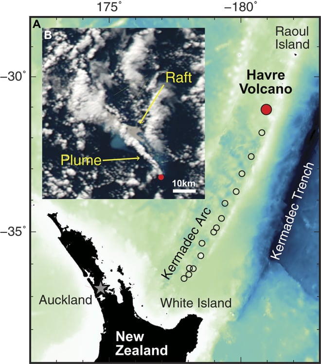
Back in 2012, the raft – composed of pumice, a type of very light, air-filled volcanic rock – covered some 400 square kilometres (154 square miles) of the south-west Pacific Ocean, but months later satellites recorded it dispersing over an area twice the size of New Zealand itself.
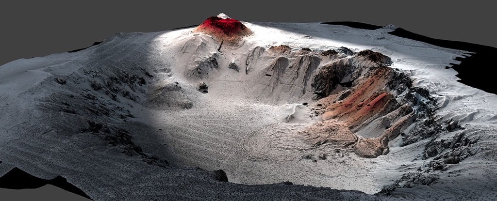
Under the surface, the sheer scale of the rocky aftermath took scientists aback when they inspected the site in 2015, at depths as low as 1,220 metres (4,000 feet).
“When we looked at the detailed maps from the autonomous underwater vehicle (AUV), we saw all these bumps on the seafloor and I thought the vehicle’s sonar was acting up,” said volcanologist Adam Soule from the Woods Hole Oceanographic Institution.
“It turned out that each bump was a giant block of pumice, some of them the size of a van. I had never seen anything like it on the seafloor.”
The investigation – conducted with the AUV Sentry and the remotely operated vehicle (ROV) Jason – reveals that Havre Seamount’s eruption was more complex than anyone topside ever knew.
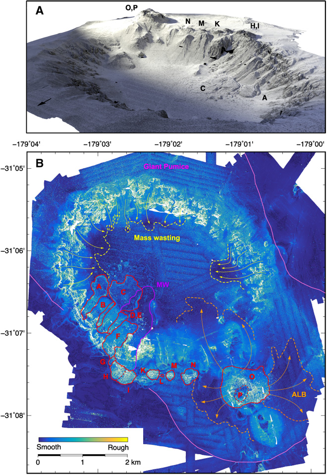
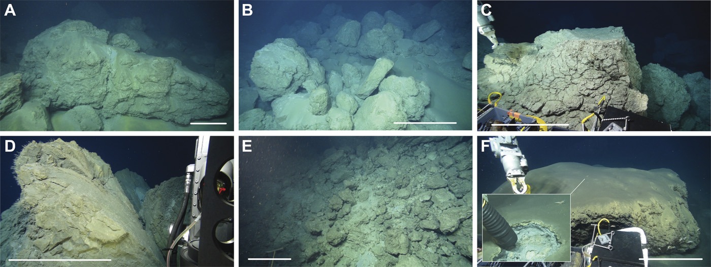
The caldera, which spans nearly 4.5 kilometres (about 3 miles), discharged lava from some 14 vents in a “massive rupture of the volcanic edifice”, producing not just pumice rock, but ash, lava domes, and seafloor lava flows.
It may have been (thankfully) buried under an ocean of water, but for a sense of scale, think roughly 1.5 times larger than the 1980 eruption of Mount St. Helens – or 10 times the size of the 2010 Eyjafjallajökull eruption in Iceland.
The rest of it was scattered around the nearby seafloor, bringing devastation to the biological communities who called it home, and are only now rebounding.
“The record of this eruption on Havre volcano itself is highly unfaithful,” said Carey.
“It preserves a small component of what was actually produced, which is important for how we interpret ancient submarine volcanic successions that are now uplifted and are highly prospective for metals and minerals.”
With samples collected by the submersibles yielding what the scientists say could amount to a decade’s worth of research, it’s a huge, rare opportunity to study what takes place when a volcano erupts under the sea – a phenomenon that actually accounts for more than 70 percent of all volcanism on Earth, even if it’s a bit harder to spot.
“Underwater eruptions are fundamentally different than those on land,” noted one of the team, geophysicist Michael Manga from UC Berkeley. “There is no on-land equivalent.”
Meanwhile, La Palma eruption is picking up in intensity… Get the latest news and pictures here.
Now subscribe to this blog to get more amazing news curated just for you right in your inbox on a daily basis (here an example of our new newsletter).
You can also follow us on Facebook and/ or Twitter. And, by the way you can also make a donation through Paypal. Thank you!
You should really subscribe to QFiles. You will get very interesting information about strange events around the world.


Good thing it happened underwater. Now let’s see how bad it gets in La Palma. It probably will get worse.
“The rest of it was scattered around the nearby seafloor, bringing devastation to the biological communities who called it home, and are only now rebounding.”
Nature survives with or without Man.
Burning logs today. House is 74°. I get an hour to an hour an a half my logs. Went down to 24° around 0500hrs.
Not too bad yet. Soon enough it will be 2°.
It’s 36*C (96.8*F) today in Perth, which is rather warm for this time of year. I can see we will probably have a very warm and humid summer with the average around 45*C and will hit a record next year around February with the hottest day of 52*C but it will be bringing in some awesome storms.