

Earthquakes · Seismology · Ground Deformation · Early Warning
Scientists monitor earthquakes using seismographs, GPS stations, satellite radar, strainmeters, gas measurements and dense sensor networks. These systems can detect fault movement, map underground deformation and provide seconds of warning after an earthquake begins—but they cannot yet reliably predict the exact time, place and magnitude of a future earthquake.
Earthquake monitoring and earthquake prediction are often confused. Monitoring observes what the Earth is doing now. Early-warning systems detect an earthquake after rupture has started and send alerts before the strongest shaking reaches more distant locations. Forecasting estimates the probability of future earthquakes over days, years or decades. Exact prediction remains an unresolved scientific challenge.
This guide explains how earthquakes are detected, how scientists measure crustal deformation, what satellites reveal about active faults, how earthquake early warning works, and why unusual signals such as earthquake lights, animal behavior and gas emissions remain difficult to interpret.
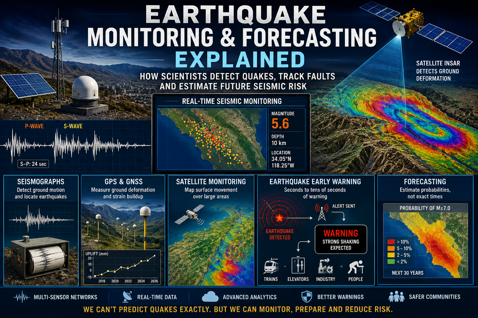
What Is Earthquake Monitoring?
Earthquake monitoring is the continuous observation of ground motion, crustal deformation and related geophysical changes in order to detect earthquakes, understand active faults and assess seismic hazards.
Modern monitoring networks combine many types of instruments. No single sensor can reveal everything happening inside a fault zone. Seismometers record vibrations, GPS stations track surface movement, satellites map deformation, and borehole instruments measure strain, pressure or fluid changes underground.
Data from these systems help scientists answer several different questions:
- Where did an earthquake occur?
- How deep was it?
- How large was the rupture?
- Which fault moved?
- How rapidly did the rupture propagate?
- How strongly did different locations shake?
- Is the crust accumulating strain?
- Are aftershocks migrating through a fault system?
- Has an earthquake changed stress on nearby faults?
Monitoring is essential for rapid earthquake information, emergency response, tsunami assessment, engineering design and long-term hazard mapping. It also provides the observational record needed to test theories about how faults behave.
Key distinction: Earthquake monitoring can detect and analyze an earthquake very quickly. It does not mean scientists knew the earthquake would occur before rupture began.
Monitoring, Early Warning, Forecasting and Prediction
These terms describe different scientific and operational tasks. Treating them as interchangeable creates unrealistic expectations about what earthquake science can currently accomplish.
| Term | What it means | Typical time scale |
|---|---|---|
| Monitoring | Continuously observing earthquakes, deformation and fault activity | Real time to decades |
| Early warning | Detecting an earthquake after it starts and alerting locations before strong shaking arrives | Seconds to tens of seconds |
| Forecasting | Estimating the probability of earthquakes in a region or time window | Days, years or decades |
| Prediction | Specifying a future earthquake’s time, location and magnitude with useful accuracy | Before rupture begins |
Monitoring
Monitoring records seismicity and deformation as they occur. It supports rapid alerts, scientific analysis and hazard assessment.
Early warning
Early warning begins only after a fault has started to rupture. Sensors near the earthquake detect the first seismic waves and transmit information faster than the damaging waves travel through the ground.
Forecasting
Forecasting estimates probabilities. A forecast might state that a fault has a particular chance of producing a large earthquake within several decades, or that the probability of another strong earthquake is temporarily elevated during an aftershock sequence.
Prediction
A scientifically useful prediction would need to identify a reasonably narrow time window, location and magnitude range before the earthquake begins. No method has demonstrated that capability consistently across different faults and tectonic settings.
Seismographs and Seismic Networks
Seismographs are the foundation of earthquake monitoring. They detect and record motion produced by seismic waves traveling through the ground.
The instrument that senses motion is commonly called a seismometer. The full recording system is often called a seismograph, while the recorded trace is a seismogram.
How a seismometer works
A seismometer compares the movement of its frame, which is attached to the ground, with the motion of an internal mass. When the ground moves, the instrument records the relative displacement or acceleration.
Modern seismometers use electronic feedback systems capable of measuring extremely small motions across a broad range of frequencies. Sensitive instruments can detect distant earthquakes, ocean waves, explosions, volcanic tremor and even vibrations produced by human activity.
Different types of seismic instruments
Broadband seismometers
Broadband instruments record a wide range of seismic frequencies and are used to study both local and distant earthquakes. They are central to regional and global seismic networks.
Strong-motion accelerometers
Strong-motion instruments are designed to remain useful during intense shaking that may overwhelm more sensitive seismometers. They provide data needed for structural engineering, building codes and damage assessment.
Short-period seismometers
Short-period instruments are particularly sensitive to higher-frequency waves from nearby earthquakes. They are often used in dense local networks.
Ocean-bottom seismometers
Because most of Earth’s surface lies beneath the ocean, ocean-bottom seismometers are essential for studying offshore faults, subduction zones and mid-ocean ridges.
Borehole seismometers
Instruments installed underground experience less interference from wind, temperature changes, traffic and surface noise. Borehole stations can detect small earthquakes that might be obscured at the surface.
How earthquakes are located
Earthquakes produce several types of seismic waves. Primary waves, or P waves, generally travel faster than secondary waves, or S waves.
The difference between the P-wave and S-wave arrival times helps estimate the distance between a seismic station and the earthquake. Combining observations from multiple stations allows scientists to calculate the earthquake’s hypocenter underground and its epicenter at the surface.
- A fault begins to rupture.
- P waves reach nearby stations first.
- S waves arrive later.
- Arrival-time differences estimate distance from each station.
- Data from several stations constrain the earthquake location and depth.
How earthquake magnitude is measured
Modern earthquake magnitude estimates are calculated from recorded seismic waves. For larger earthquakes, moment magnitude is widely used because it relates to the size of the fault area, the amount of displacement and the rigidity of the rocks.
Initial automatic magnitude estimates may be revised as more stations report data and longer portions of the rupture are analyzed.
Dense seismic networks
A single station can detect shaking, but a network reveals where it came from and how it evolved. Dense networks improve:
- earthquake location accuracy;
- detection of small earthquakes;
- aftershock mapping;
- fault-zone imaging;
- rapid magnitude estimation;
- strong-shaking maps;
- earthquake early warning.
What small earthquakes reveal
Small earthquakes can outline active faults that are not visible at the surface. Their distribution may reveal fault geometry, fluid movement, stress changes and the structure of complex rupture zones.
However, an increase in small earthquakes does not automatically mean that a large earthquake is imminent. Many earthquake swarms end without producing a major event.
GPS and Ground Deformation
Earth’s crust is constantly moving. Tectonic plates converge, separate and slide past one another, while faults may remain locked for decades or centuries before rupturing.
High-precision Global Positioning System stations can measure this movement with millimeter-scale accuracy. Scientists often use the broader term GNSS, or Global Navigation Satellite System, because modern receivers can use multiple satellite constellations.
How GPS monitors active faults
Permanent GPS stations repeatedly calculate their position relative to orbiting satellites. Comparing measurements through time reveals whether the ground is moving north, south, east, west, upward or downward.
Networks positioned across active plate boundaries can show:
- plate-motion rates;
- fault locking;
- strain accumulation;
- slow slip;
- subsidence or uplift;
- movement during an earthquake;
- post-earthquake deformation.
Locked faults and strain accumulation
A fault may be locked at depth even while the tectonic plates continue moving. The surrounding crust bends and stores elastic strain.
GPS stations on opposite sides of the fault can reveal this deformation. Scientists use the observed pattern to estimate which portions of the fault are locked and how quickly strain is accumulating.
This does not reveal the exact date of the next earthquake. It helps define where large earthquakes are physically possible and how much tectonic movement is being stored.
Coseismic displacement
Ground movement occurring during an earthquake is called coseismic displacement. Nearby GPS stations may shift by centimeters or meters within seconds or minutes.
These observations help estimate fault slip, rupture dimensions and the total seismic moment of the earthquake.
Postseismic deformation
The crust can continue moving after a major earthquake. This postseismic deformation may result from:
- afterslip on the fault;
- viscous flow deeper in the Earth;
- poroelastic adjustment involving underground fluids;
- stress redistribution to neighboring faults.
Monitoring these movements helps scientists understand how the crust recovers and how stress evolves after large ruptures.
Slow-slip events
Some faults move slowly over days, weeks or months without producing strong seismic waves. These slow-slip events are especially important in subduction zones.
Slow slip can release part of the accumulated strain, transfer stress to adjacent fault segments or occur alongside tremor and small earthquakes. Its relationship to major earthquakes is still an active area of research.
Strainmeters and tiltmeters
GPS is often combined with instruments that measure extremely small changes in crustal strain or ground tilt.
Borehole strainmeters can detect deformation too subtle or rapid for some GPS networks. Tiltmeters measure tiny changes in surface slope and are also widely used in volcanic monitoring.
Satellite Earthquake Monitoring
Satellites allow scientists to monitor deformation across vast regions, including deserts, mountains, offshore margins and politically inaccessible areas.
Satellite observations are particularly valuable when ground-based instruments are sparse or damaged.
InSAR: radar measurements of ground movement
Interferometric Synthetic Aperture Radar, commonly called InSAR, compares radar images of the same area collected at different times.
Small changes in the distance between the satellite and the ground alter the radar signal. These differences can be processed into maps showing surface displacement.
InSAR can detect:
- coseismic deformation during earthquakes;
- slow fault movement;
- postseismic deformation;
- subsidence caused by groundwater extraction;
- uplift or subsidence near volcanoes;
- landslides and unstable slopes;
- deformation across broad tectonic regions.
Interferograms
InSAR results are often displayed as colored interference fringes. Each complete color cycle represents a particular amount of movement toward or away from the satellite.
The pattern can reveal the location, orientation and approximate slip distribution of a fault rupture, even when the fault did not produce an obvious surface break.
Advantages of satellite radar
- covers large areas;
- requires no instrument directly at the deformation site;
- works during day or night;
- can observe remote regions;
- provides spatially continuous deformation maps;
- supports rapid post-earthquake assessment.
Limitations of InSAR
InSAR is powerful but not perfect. Dense vegetation, snow, atmospheric water vapor and changes to the ground surface can reduce data quality.
Satellites also observe the surface only when they pass over the region. Their measurements are therefore not always continuous or immediate.
Optical satellite imagery
High-resolution optical images can reveal fault offsets, landslides, damaged roads, collapsed buildings and changes to river channels.
Comparing images acquired before and after an earthquake helps map the rupture and prioritize emergency response.
Satellite gravimetry and thermal observations
Researchers have investigated whether changes in gravity, surface temperature or atmospheric conditions might reveal earthquake-related processes.
Such signals are difficult to isolate because weather, groundwater, seasonal cycles and human activity can produce similar variations. They remain research tools rather than reliable standalone prediction methods.
Earthquake Early Warning
Earthquake early-warning systems detect an earthquake after it begins and issue alerts before the strongest shaking reaches locations farther from the fault.
They do not predict earthquakes. Their advantage comes from the fact that electronic signals travel faster than seismic waves.
How earthquake early warning works
- A fault begins to rupture.
- Nearby sensors detect the first-arriving P waves.
- Computer systems estimate the earthquake’s location and size.
- Alerts are transmitted to areas expected to experience strong shaking.
- Slower, more damaging seismic waves arrive afterward.
Depending on distance from the rupture and network performance, users may receive no warning, a few seconds of warning or several tens of seconds.
What can be done with a few seconds?
Even brief warning can allow automated systems and individuals to take protective action.
- trains can slow or stop;
- industrial machinery can shut down;
- elevators can stop at the nearest floor;
- operating-room staff can stabilize procedures;
- gas valves can close;
- workers can move away from dangerous equipment;
- people can drop, cover and hold on.
The blind zone
Locations very close to the earthquake source may receive little or no useful warning because strong shaking arrives almost immediately.
This area is sometimes called the blind zone. Faster algorithms and denser sensor networks can reduce it, but they cannot eliminate the physical travel-time limitation.
Why early estimates can change
Large earthquakes develop over time as the rupture spreads along a fault. The first few seconds may resemble a smaller earthquake, making rapid magnitude estimation difficult.
Early-warning systems continually update their estimates as additional data arrive.
Dedicated child pillar
How Earthquake Early Warning Systems Work
Explore P-wave detection, alert delivery, warning times, blind zones, automated safety actions and the limitations of real-time earthquake alerts.
Earthquake Forecasting
Earthquake forecasting estimates the probability that earthquakes of a particular size will occur in a region during a stated time period.
Forecasts do not usually claim that an earthquake will occur on a specific date. They describe changing levels of likelihood and uncertainty.
Long-term earthquake forecasts
Long-term forecasts often cover decades. They are based on:
- known active faults;
- past earthquake recurrence;
- geological evidence of prehistoric ruptures;
- GPS-measured strain rates;
- fault slip rates;
- regional seismicity;
- statistical earthquake models.
These forecasts inform building codes, insurance models, infrastructure planning and emergency preparation.
Paleoseismology
Paleoseismology studies earthquakes that occurred before modern instruments and written records.
Researchers excavate trenches across faults and examine displaced sediment, buried soils, tsunami deposits and other geological evidence. Dating these layers helps reconstruct the timing and size of past earthquakes.
Recurrence intervals are usually irregular. A fault that ruptured every few centuries in the past is not operating on a precise calendar.
Aftershock forecasting
After a large earthquake, scientists can estimate the probability of additional earthquakes in the affected region.
Aftershocks generally become less frequent with time, but strong events remain possible. In some sequences, an earthquake initially classified as the mainshock is later recognized as a foreshock when a larger rupture occurs.
Operational earthquake forecasting
Operational earthquake forecasting updates probabilities as new earthquakes occur. It combines real-time seismic observations with statistical models.
These forecasts can communicate that earthquake likelihood is elevated without claiming that a specific large earthquake is certain.
Seismic gaps
A seismic gap is a section of an active fault or plate boundary that has experienced fewer recent earthquakes than neighboring segments.
Some gaps may represent locked zones accumulating strain. However, not every quiet segment will rupture soon, and some major earthquakes occur outside previously identified gaps.
Stress transfer and earthquake triggering
An earthquake changes stress in the surrounding crust. Some nearby faults may be moved closer to failure, while others may be temporarily relieved.
Scientists model these changes to identify areas where aftershock or earthquake probabilities may have increased. The calculations are useful but depend on imperfect knowledge of fault geometry, friction and subsurface stress.
Foreshocks
Some large earthquakes are preceded by smaller earthquakes near the eventual rupture zone. These are called foreshocks—but they can only be identified with certainty after the larger earthquake occurs.
Most small earthquakes are not followed by a major rupture, which makes foreshocks difficult to use as reliable warnings.
Earthquake swarms
Earthquake swarms are clusters of earthquakes without one clearly dominant mainshock. They may result from fluid movement, volcanic activity, slow fault slip or changing stress.
Some swarms precede larger earthquakes, but many fade without producing a damaging event. Context matters.
Earthquake Lights
Earthquake lights are unusual luminous phenomena reported before, during or after some earthquakes. Descriptions include flashes, glowing clouds, columns of light and colored illumination near the horizon.
Some events have been photographed or recorded, but many historical reports are difficult to verify. Electrical infrastructure failures, transformers, lightning, fires and camera artifacts can produce similar appearances.
Proposed explanations
Hypotheses include:
- electrical charge generated in stressed rocks;
- ionization of air near fractured ground;
- piezoelectric or electrokinetic effects;
- plasma-like discharges;
- disturbance of underground electrical currents;
- arcing from damaged power systems.
Can earthquake lights predict earthquakes?
No reliable earthquake-prediction method currently exists based on lights. Reports are rare, inconsistent and often documented only after an earthquake has occurred.
For a precursor to be operationally useful, it would need to occur consistently before earthquakes, be clearly distinguishable from unrelated phenomena and provide meaningful information about time, location and magnitude.
Animal Behavior Before Earthquakes
Reports of unusual animal behavior before earthquakes date back centuries. Dogs may bark or hide, birds may leave roosts, fish may behave erratically and livestock may become restless.
The central scientific question is not whether animals sometimes react before people notice an earthquake. Animals can detect weak vibrations, sounds and environmental changes. The question is whether their behavior provides a consistent and specific warning of a future damaging earthquake.
What animals might detect
Possible signals include:
- weak foreshocks;
- high-frequency vibrations;
- low-frequency sound;
- groundwater changes;
- gas emissions;
- electrical or magnetic variations;
- subtle ground deformation.
Why animal behavior is difficult to use
Animals change behavior for many reasons, including weather, predators, illness, food, noise, human activity and seasonal cycles.
Reports also suffer from hindsight bias. Unusual behavior is more likely to be remembered and reported after an earthquake, while identical behavior on ordinary days is forgotten.
Controlled monitoring
Some researchers use movement sensors, farm records, cameras and automated tracking to compare animal activity with seismic data.
These studies may reveal responses to weak shaking or other environmental signals, but no animal-based system has yet demonstrated reliable earthquake prediction across different regions and species.
Animals and early detection
Animals may react to P waves before humans feel the stronger S waves. In that case, they are detecting an earthquake that has already begun, not predicting it in advance.
Earth Degassing and Gas Emissions
The Earth continuously releases gases through faults, fractures, soils, groundwater systems and volcanic regions. Researchers have investigated whether changes in these emissions could accompany stress accumulation or rock fracturing before earthquakes.
Radon
Radon is a radioactive gas produced by the decay of uranium in rocks and soil. It can move through fractures and dissolve in groundwater.
Some studies have reported changes in radon concentration before earthquakes. Proposed explanations include the opening of microfractures, pressure changes and altered groundwater circulation.
However, radon levels also vary because of:
- rainfall;
- air pressure;
- temperature;
- soil moisture;
- groundwater movement;
- ventilation;
- seasonal cycles.
These influences make it difficult to identify a uniquely earthquake-related signal.
Carbon dioxide
Carbon dioxide can rise through deep faults and hydrothermal systems. Changes may reflect fluid migration, pressure variations, volcanic unrest or biological processes in the soil.
Elevated carbon dioxide is therefore not automatically a sign of an impending earthquake.
Helium and other gases
Helium isotopes can reveal whether fluids originate from the crust, mantle or atmosphere. Researchers sometimes study helium, hydrogen, methane and other gases near active faults.
These measurements can improve understanding of deep fluid pathways, but no individual gas has become a dependable earthquake-prediction tool.
Groundwater chemistry
Stress and fracturing can change groundwater flow, temperature, pressure and dissolved minerals. Wells may rise, fall, become cloudy or show chemical changes.
Similar variations can also result from rainfall, pumping, drought, tides and human activity.
Why gas monitoring remains valuable
Even when gases cannot predict earthquakes, they can reveal active fluid circulation, fault permeability and connections between tectonic and volcanic systems.
The strongest studies combine gas observations with seismic, deformation, hydrological and meteorological data rather than treating a single anomaly as proof of an impending earthquake.
Why Earthquakes Cannot Yet Be Reliably Predicted
Fault systems are hidden deep underground, heterogeneous and influenced by processes that cannot be measured completely. Scientists can observe the surface expression of tectonic strain, but they cannot directly monitor every part of a fault.
Faults are complex
Faults are not smooth, uniform surfaces. They contain bends, branches, damaged rock, fluids and patches with different frictional properties.
A rupture may stop after producing a small earthquake or continue across multiple segments and become a major event.
Small and large earthquakes may begin similarly
The earliest moments of a small earthquake may resemble the beginning of a larger rupture. Scientists often cannot determine immediately whether the rupture will stop or continue growing.
Precursors are inconsistent
Proposed precursors include foreshocks, gas changes, groundwater anomalies, electromagnetic signals, lights and animal behavior.
The problem is that:
- many earthquakes occur without an obvious precursor;
- many anomalies occur without a subsequent earthquake;
- signals may be identified only in hindsight;
- measurements may be affected by weather or human activity;
- different fault systems may behave differently.
False alarms carry consequences
A prediction system must balance missed events against false alarms. Frequent false warnings can cause economic disruption, unnecessary evacuations and loss of public trust.
Rare events are difficult to test
Large earthquakes on an individual fault may be separated by centuries. This makes controlled testing and statistical validation extremely difficult.
What science can do: map active faults, estimate long-term probabilities, monitor changing seismicity, forecast aftershocks and provide early warning once an earthquake begins.
The Future of Earthquake Monitoring and Forecasting
Earthquake monitoring is advancing rapidly as instruments become cheaper, communication networks become faster and computing systems process larger volumes of data.
Denser sensor networks
More seismic and GPS stations improve detection, location and real-time estimates. Low-cost sensors can supplement professional networks in urban areas.
Smartphones and connected devices
Smartphones contain accelerometers capable of detecting motion. Large networks of connected devices may help identify shaking and distribute alerts, although professional instruments remain essential for accuracy.
Distributed acoustic sensing
Fiber-optic cables can be used as dense arrays of vibration sensors. Laser pulses traveling through the cable reveal tiny strain changes along its length.
Existing telecommunications cables may eventually provide extensive seismic coverage across cities, remote land areas and the seafloor.
Artificial intelligence
Machine-learning systems can identify small earthquakes, distinguish seismic signals from noise and process large archives of waveform data.
AI may improve detection and forecasting models, but its output depends on the quality and representativeness of the training data. Pattern recognition is not the same as proven earthquake prediction.
Improved seafloor monitoring
Many dangerous faults lie offshore, where instruments are sparse and expensive to maintain. Expanded ocean-bottom seismic, pressure and geodetic networks could improve monitoring of subduction zones.
Real-time fault models
Combining seismology, GPS, InSAR and geological data may allow faster estimates of how a rupture is evolving and which areas are likely to experience strong shaking.
Multi-parameter monitoring
The most promising future systems will likely combine many observations rather than rely on a single precursor.
- seismicity;
- ground deformation;
- strain;
- fluid pressure;
- gas chemistry;
- electromagnetic measurements;
- satellite observations.
Even with better instruments, uncertainty will remain a defining feature of earthquake science. The goal is not to eliminate uncertainty, but to communicate it clearly and use available information to reduce risk.
Earthquake Monitoring Methods Compared
| Monitoring method | What it measures | Main strength | Main limitation |
|---|---|---|---|
| Seismographs | Ground vibration and seismic waves | Rapid earthquake detection and location | Do not directly measure slow strain accumulation |
| Strong-motion sensors | Intense ground acceleration | Engineering and damage assessment | Usually concentrated in populated areas |
| GPS and GNSS | Three-dimensional surface movement | Measures plate motion, fault locking and coseismic displacement | Station coverage may be sparse |
| InSAR | Surface displacement from satellite radar | Large-area deformation mapping | Limited by satellite revisit time and surface conditions |
| Strainmeters | Very small changes in crustal strain | Detects subtle deformation | Expensive and highly localized |
| Gas monitoring | Radon, carbon dioxide, helium and other gases | Reveals fluid movement and fault permeability | Strongly influenced by environmental conditions |
| Animal monitoring | Changes in animal activity | May detect subtle environmental signals | Behavior is nonspecific and difficult to validate |
Frequently Asked Questions About Earthquake Monitoring and Forecasting
How are earthquakes detected?
Earthquakes are detected by seismometers that record ground motion. Data from several stations are combined to calculate the earthquake’s location, depth and magnitude.
What is the difference between a seismograph and a seismometer?
A seismometer is the instrument that senses ground motion. A seismograph commonly refers to the complete recording system, while the resulting record is called a seismogram.
Can scientists predict earthquakes?
Scientists cannot currently predict the exact time, location and magnitude of future earthquakes with dependable accuracy. They can estimate long-term probabilities, forecast aftershock activity and issue early warnings after a rupture begins.
Is earthquake early warning the same as prediction?
No. Early-warning systems detect an earthquake after it has started and send alerts before the strongest shaking reaches more distant locations. Prediction would identify the earthquake before rupture begins.
How much warning can an earthquake early-warning system provide?
Warning time depends on distance from the fault, sensor density and processing speed. Locations near the rupture may receive no useful warning, while areas farther away may receive several seconds or tens of seconds.
How does GPS help monitor earthquakes?
High-precision GPS stations measure millimeter-scale crustal movement. They reveal plate motion, fault locking, strain accumulation, slow slip and displacement during and after earthquakes.
How do satellites monitor faults?
Satellite radar uses InSAR to compare repeated observations of the same region. Differences between images reveal surface deformation caused by earthquakes, slow fault movement and post-earthquake adjustment.
Do small earthquakes mean a large earthquake is coming?
Usually not. Small earthquakes and swarms are common, and most are not followed by a major event. Some large earthquakes have foreshocks, but foreshocks can only be identified with certainty afterward.
Can earthquake lights predict earthquakes?
No reliable prediction method is based on earthquake lights. Some reports may involve genuine geophysical effects, while others may be caused by electrical failures, weather, fires or misidentification.
Can animals sense earthquakes before humans?
Some animals may detect weak vibrations or P waves before people feel strong shaking. However, animal behavior has not proved sufficiently consistent or specific for reliable earthquake prediction.
Does radon increase before earthquakes?
Changes in radon have been reported before some earthquakes, but radon also varies with rainfall, pressure, soil moisture, groundwater and ventilation. It is not a reliable standalone earthquake predictor.
What is earthquake forecasting?
Earthquake forecasting estimates the probability of earthquakes in a specified region and time period. Forecasts may cover aftershock sequences, several years or multiple decades.
What is a seismic gap?
A seismic gap is a relatively quiet section of an active fault or plate boundary. It may represent a locked segment accumulating strain, but silence alone does not reveal when or whether a large earthquake will occur.
Will artificial intelligence make earthquake prediction possible?
Artificial intelligence can improve earthquake detection, signal classification and statistical forecasting. It has not yet demonstrated reliable exact prediction of future earthquakes.
Monitoring Earthquakes Means Managing Uncertainty
Earthquake monitoring has transformed seismology. Seismographs can locate ruptures within minutes, GPS stations measure the slow movement of tectonic plates, and satellite radar maps ground deformation across entire regions.
Early-warning systems can provide valuable seconds after an earthquake begins. Forecasting models can estimate where earthquakes are more likely over years or decades. Aftershock forecasts can help emergency managers understand how risk changes following a major event.
What these systems cannot yet do is announce the exact time, place and magnitude of the next major earthquake before rupture starts. Proposed precursors such as lights, unusual animal behavior and gas emissions remain inconsistent and difficult to separate from ordinary environmental variation.
The practical goal of earthquake science is therefore not to promise certainty where none exists. It is to detect earthquakes faster, understand faults better, improve warnings, communicate probability clearly and give communities the information they need to prepare before the ground begins to move.
“`html
