Typhoon in February are extremely rare! Well, Wutip has become the strongest ever typhoon to churn in the western Pacific Ocean during February overnight as it lashed Guam with flooding rain, strong winds and pounding seas.
Wutip strengthened into a super typhoon on Saturday night, local time. It again became a typhoon on Sunday.
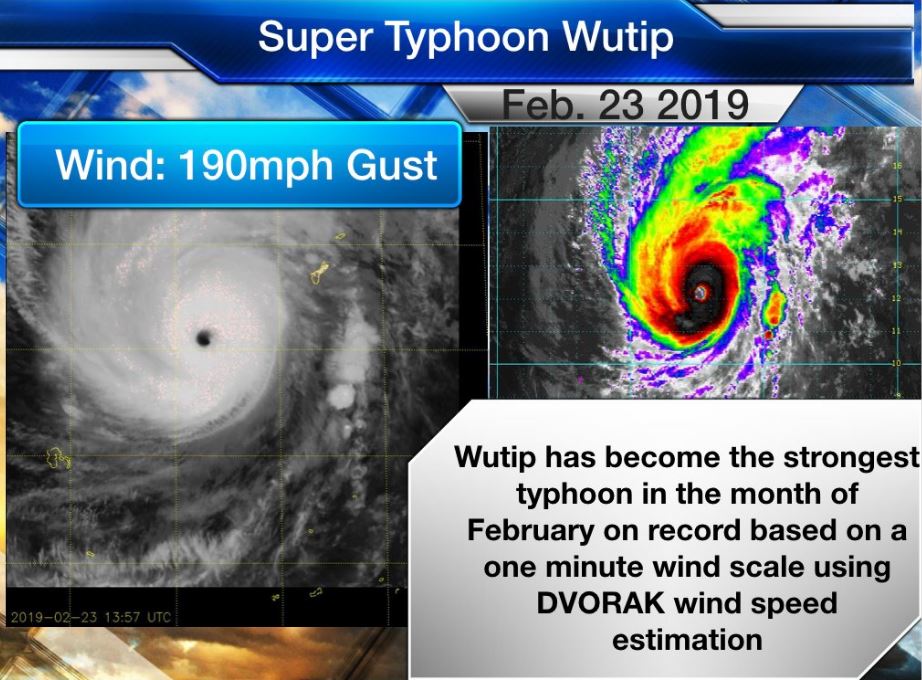
With its strength equivalent to a strong Category 4 hurricane in the Atlantic or eastern Pacific oceans, Wutip surpassed Higos from 2015 as the strongest super typhoon on record during the month of February in the western Pacific Ocean.
Meanwhile, on the other side of the world our American friends in Guam are currently feeling the effects of the strongest Typhoon in the month of February on record via JTWC. TS strength winds being felt on the island. #wutip #guam pic.twitter.com/OQ6i34pcBo
— Robert Speta (@WHEC_RSPETA) February 23, 2019
While Guam and the Northern Mariana Islands will escape a direct hit by the powerful typhoon’s most destructive winds and torrential rain, residents should not let their guard down.
Not everyday you see a super typhoon just below CAT 5 status in FEBRUARY. Wutip’s inner core is beautiful w/ a well defined eye and a well rounded CDO. Definitely one for the history books!! pic.twitter.com/8AKTq5wXCD
— TJ (@TJ05650196) February 23, 2019
Since Guam will be the closest island Wutip tracks near, residents can anticipate to bear the worst conditions when compared to the Northern Mariana Islands.

Wutip was churning southwest of Guam when it became a super typhoon on Saturday night, local time. (Satellite/NOAA)
“Even without a direct hit, Wutip is tracking close enough to Guam to deliver heavy downpours and strong, tropical-storm-force winds,” according to AccuWeather Meteorologist Brian Thompson.
Torrential rain and strong winds will further lash the island during the second half of the weekend.
Typhoon #Wutip southwest of #Guam from #Himawari-8 pic.twitter.com/CbdfJmmuXm
— Dan Lindsey (@DanLindsey77) February 24, 2019
Winds can continue to gust between 40 and 60 mph (65 and 95 km/h) with the highest gusts across the southern half of the island. Such winds can cause tree damage and lengthy power outages. Damage to weaker structures may also result.
Guam International Airport has received about 3.29 inches (84 mm) of rain so far from Wutip. More rain is to come from Wutip. Some wind gusts up to about 55 mph (89 km/h) have also been reported.
Heavy rainfall can total 4 to locally 8 inches (100-200 mm), leading to flash flooding in flood-prone areas. Mudslides can be triggered in the higher terrain.

The waters surrounding Guam and the Northern Mariana Islands will become extremely dangerous for boaters and swimmers. Seas can reach 20 to 25 feet (6 to 8 meters) around Guam with seas around 35 feet (10 meters) closer to the storm’s center.
In addition to boats being forced to remain in port, flight cancellations can be expected. Road closures can occur due to flooding and/or tree damage.
Residents should be ready to endure lengthy power outages. The prolonged adverse conditions may prevent crews from restoring electricity to residents who lose power during the early part of the storm.

Numerous events have already been postponed or canceled due to the typhoon.
The risk for flooding and wind damage is expected to be more sporadic across the Northern Mariana Islands.
After impacting the islands this weekend, Wutip will move slowly away from Guam and the Northern Mariana Islands the rest of the week.
Wutip is expected to weaken and be well past its peak intensity. Boaters should still remain vigilant for choppy to rough seas in the vicinity of the storm.
There has not been a typhoon to roam the waters of the western Pacific Ocean during the month of February since Higos in 2015. Higos remained well to the east of Guam.


Those who made the photo from above;. Surely they are the ones who caused it. HAARP Induced