3 volcano-tectonic quakes were recorded at Zambales province within the last 24 hours.
And we all know that Mount Pinatubo is the only active volcano in this province… So? Is it preparing its next big blast?

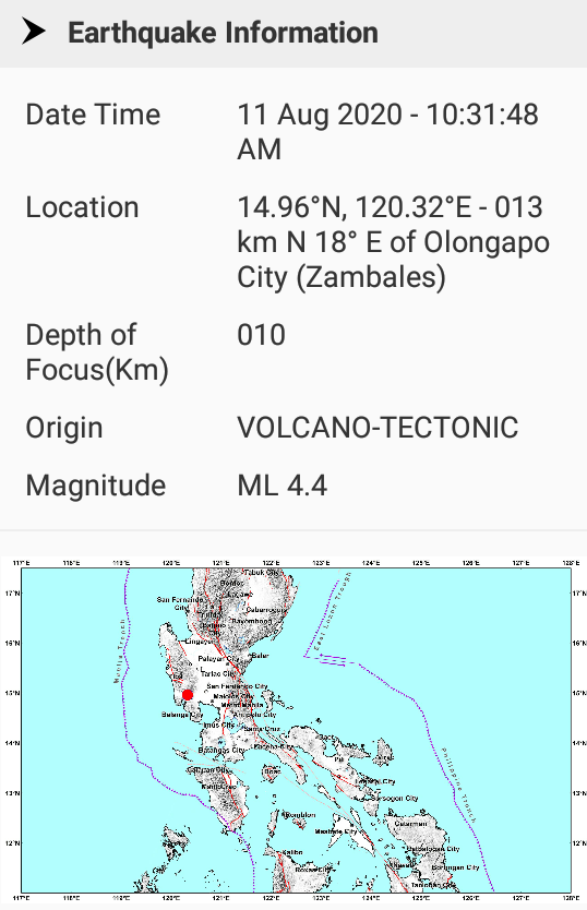
A M4.4 earthquake first hit 16 km northeast of Olongapo City at a depth of 10 km.
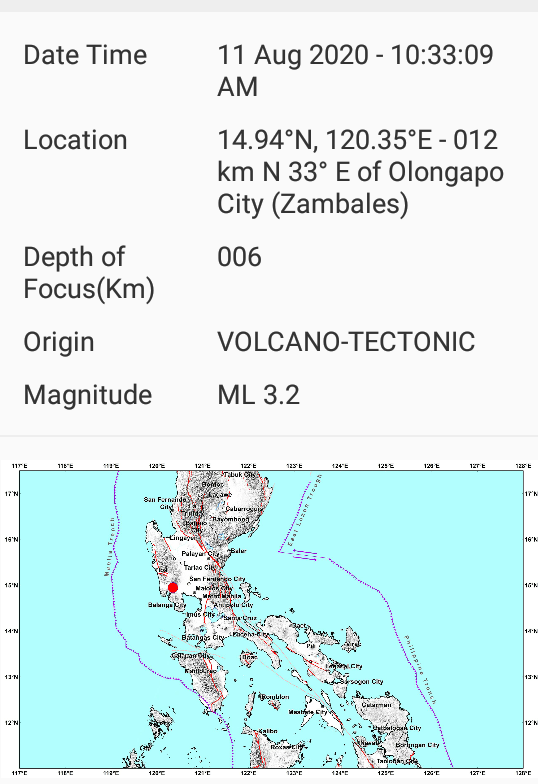
The first quake was followed by a M3.2 in the same area, approximately 12 km northeast of Olongapo city at a depth of 6 km.
Finally, the last M4.3 earthquake occurred on August 12, 2020, 10:47 AM 13 km southeast of Olongapo city, zambales at a depth of 9 km.

A volcano tectonic earthquake is a tremor caused by the movement of magma beneath the surface of the Earth. The movement results in pressure changes where the rock around the magma has experienced stress. At some point, this stress can cause the rock to break or move. This seismic activity is used by scientists to monitor volcanoes.
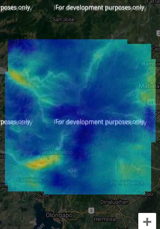
The below satellite image by MIROVA clearly shows that a recharging process is going on near San Marcelino (yellow-red color; SW of the volcano). This movement of magma is not surprising in the area, since the first two above volcano-tectonic earthquakes hit this exact area.
So is Pinatubo preparing for the next eruption? Not according to officials… Mt. Pinatubo remains in alert level 0 which means that the volcano is showing no irregularity in its current state… And thus there is no sign of incoming eruption…
Last eruption of Pinatubo
The second-largest volcanic eruption of XXth century, and by far the largest eruption to affect a densely populated area, occurred at Mount Pinatubo in the Philippines on June 15, 1991.
The eruption produced high-speed avalanches of hot ash and gas, giant mudflows, and a cloud of volcanic ash hundreds of miles across. The impacts of the eruption continue to this day.
Nearly 20 million tons of sulfur dioxide were injected into the stratosphere in Pinatubo’s 1991 eruptions, and dispersal of this gas cloud around the world caused global temperatures to drop temporarily (1991 through 1993) by about 1°F (0.5°C).
June 15, 1991
From June 7 to 12, the first magma reached the surface of Mount Pinatubo. Because it had lost most of the gas contained in it on the way to the surface (like a bottle of soda pop gone flat), the magma oozed out to form a lava dome but did not cause an explosive eruption. However, on June 12 (Philippine Independence Day), millions of cubic yards of gas-charged magma reached the surface and exploded in the reawakening volcano’s first spectacular eruption.
When even more highly gas charged magma reached Pinatubo’s surface on June 15, the volcano exploded in a cataclysmic eruption that ejected more than 1 cubic mile (5 cubic kilometers) of material. The ash cloud from this climactic eruption rose 22 miles (35 kilometers) into the air.
At lower altitudes, the ash was blown in all directions by the intense cyclonic winds of a coincidentally occurring typhoon, and winds at higher altitudes blew the ash southwestward. A blanket of volcanic ash (sand- and silt-size grains of volcanic minerals and glass) and larger pumice lapilli (frothy pebbles) blanketed the countryside. Fine ash fell as far away as the Indian Ocean, and satellites tracked the ash cloud several times around the globe.
Huge avalanches of searing hot ash, gas, and pumice fragments (pyroclastic flows) roared down the flanks of Mount Pinatubo, filling once-deep valleys with fresh volcanic deposits as much as 660 feet (200 meters) thick. The eruption removed so much magma and rock from below the volcano that the summit collapsed to form a large volcanic depression (caldera) 1.6 miles (2.5 kilometers) across.
Consequences
Following Mount Pinatubo’s cataclysmic June 15, 1991, eruption, thousands of roofs collapsed under the weight of ash made wet by heavy rains.
Ash deposits from the eruption have also been remobilized by monsoon and typhoon rains to form giant mudflows of volcanic materials (lahars), which have caused more destruction than the eruption itself.
The eruptions have dramatically changed the face of central Luzon, home to about 3 million people. About 20,000 indigenous Aeta highlanders, who had lived on the slopes of the volcano, were completely displaced, and most still wait in resettlement camps for the day when they can return home.
About 200,000 people who evacuated from the lowlands surrounding Pinatubo before and during the eruptions have returned home but face continuing threats from lahars that have already buried numerous towns and villages.
If this trend continues, I would start worrying a lot. More earthquake news on Strange Sounds and Steve Quayle. [USGS]
Now if you are looking for supplements to increase your healthy lifestyle and sexlife please visit Natural Health Source.


It is absolutely mother earth is in agony, and misery. So we the people of this planet as well are in agony, and misery.