We’ve got another one for your 2020 list…
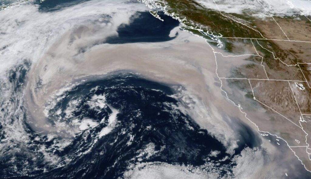
A swath of wildfire smoke is getting pulled into an offshore storm.

I’m going to file this under “I’ve never seen this in my career, but I probably should have expected it this year” as some of this thick smoke from the historic fires burning in Oregon and California is now getting sucked right into a Pacific storm.
First you had the twice-in-a-century major east wind event in September. That combined for extremely dry air and near hurricane-force wind gusts in spots to create a nearly unprecedented extreme fire danger.
The “Extreme Fire Danger” forecast given by NOAA’s Storm Prediction Center for NW Oregon was indeed just the second ever given in Oregon’s history.
OK this seems very 2020: The offshore smoke is now getting sucked into that swirling storm out in the Pacific:
— Scott Sistek (@ScottSKOMO) September 12, 2020
MORE: https://t.co/XFzMPeSLSU#wawx pic.twitter.com/LpibEVTAsw
Oh, and that east wind dries further when it sinks down mountain slopes, bringing relative humidity ranges into the teens and of course it hadn’t rained much of anything in the past 5 weeks.
As feared, all the ingredients combined to create massive forest fires that the National Weather Service estimates has so far burned about 10% of the entire forested lands along the western slopes of the Cascades between Eugene and the Columbia River.
Massive forest fires mean “super massive” amounts of smoke, as the Department of Ecology put it, which turned much of Oregon and northern California into an orange haze worthy of a filming location for Blade Runner with no need for added special effects.
But as strange as that all was, an even stranger event occurred – the east wind kept blowing, and instead of that smoke getting carried off to the east like in the typical flow of the planet, the smoke was carried west out to sea.
A loooooooong way out to sea. NOAA has estimated the smoke has traveled from about 1,000 to 1,300 miles off shore.
This is why the marine breezes that usually clear out the smoke with cool, clean air is instead making the smoke so much worse as that ocean smoke blows our way.
But farther out to sea, the smoke is getting pulled farther to the east by a wandering low pressure system that is now sucking up the smoke into its center swirl!
Clouds of smoke from wildfires in the western United States are billowing over the Pacific Ocean. Imagery from the joint NASA & @NOAA Suomi NPP satellite shows winds changing direction; by Sep. 10, the smoke had traveled over 1,300 miles: https://t.co/siXDCdQaPd pic.twitter.com/ND1PJq2Wvk
— NASA (@NASA) September 11, 2020
That low is expected to drift toward the Northwest over the weekend arriving around Monday or Tuesday and hopefully bringing some showers. And I’d hope the smoke would dissipate inside the turbulent mixing of the low before it gets here.
More strange weather phenomena on KOMO News, Strange Sounds and Steve Quayle.


Interesting Sat. Image ( Picture: GOES-17/NOAA) Of the Pacific Coastline and inland. There’s a lot of fires and smoke Below The US /Canadian Border, not such North of the border. Interesting.