As the latest overachieving storm in an unforgiving and record-setting season, Hurricane Zeta roared ashore in southeast Louisiana on Wednesday afternoon.
The powerful Category 2 hurricane, which struck near Cocodrie, La., intensified right up until landfall, defying earlier forecasts for a substantially weaker storm.
BREAKING: Over 1 Million customers across the country are without power this evening.
— The Weather Channel (@weatherchannel) October 29, 2020
Our #Zeta coverage continues throughout the night. pic.twitter.com/NES4tpVAMW
Shortly after crossing the coast, Zeta slammed into New Orleans, its eye moving directly over the city, cutting power to more than 80 percent of its residents.
Eyewall of #Zeta ripping into #NOLA now pic.twitter.com/x7RFA9uWT4
— Rob Marciano (@RobMarciano) October 28, 2020
Hurricane Zeta knocks out power on Bourbon Street. @FOX8NOLA pic.twitter.com/sgu7JCzYuO
— Garland Gillen (@garlandgillen) October 29, 2020
City officials said that more than 200 trees were down across the city and that one man, electrocuted by downed power lines, died.
This before and during is EPIC!!!
— Mark Sudduth (@hurricanetrack) October 29, 2020
Gulfport, Mississippi at Courthouse Road ?? pic.twitter.com/618JY0zDvR
The storm unleashed wind gusts over 100 mph in both coastal Louisiana and Mississippi, and the high winds cut power to over 800,000 customers in Louisiana, Mississippi and Alabama.
@MargaretOrr #zeta #HurricaneZeta Metairie, La watch the sky turn blue as transformers blow and listen to the eerie sounds pic.twitter.com/3K4rbT6gbl
— David McShane (@David68735175) October 29, 2020
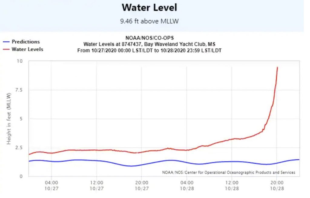
Coastal Mississippi was also subject to a storm surge that raised water levels nine feet above normally dry land at the coast, resulting in severe inundation.

Surge is really coming up in Biloxi. We are safe on third level of parking garage now and all the lights are out. #Zeta is no joke. It’s howling. @spann @FOX10News pic.twitter.com/YroOKQ4rKs
— Ryan Jackson (@RJack_5) October 29, 2020
Earlier storm surge flooding at the Golden Nugget in Biloxi, MS. The water levels have come up 1-2 feet since this was shot @JimCantore #HurricaneZeta pic.twitter.com/0aJXNkr9rm
— Greg Diamond (@gdimeweather) October 29, 2020
Zeta will travel 1,250 miles in 24 hours
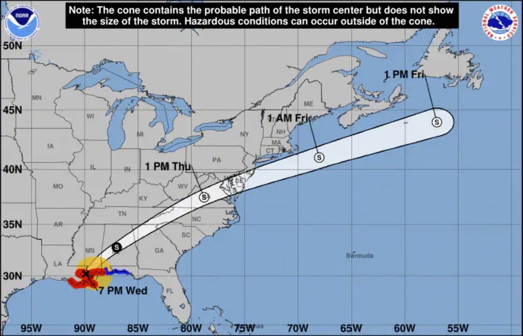
Zeta is now poised to race through central Alabama, northern Georgia and the Mid-Atlantic. That’s a trip of more than 1,200 miles in 24 hours, which averages out to 50 miles per hour. That’s faster than a vehicle on the interstate would be able to cover that distance — since the hurricane can take a direct route.
The storm could impact the United Kingdom into early next week.

Damaging winds could stretch into interior parts of Georgia, where gusts to 50 mph are forecast in Atlanta.
Torrential rain is expected all along its path, with widespread amounts of two to four inches and locally up to half a foot. Some flooding is likely.
Hurricane Zeta is a historic storm by many measures
When Zeta first formed on Saturday, it became the earliest 27th named storm on record in the Atlantic and marked only the second instance of this many storms in a calendar year, matching 2005.
But upon rapidly intensifying in the Gulf of Mexico and making landfall as a strong Category 2 hurricane in southeast Louisiana, it established several more significant milestones:
- In its 26 hours prior to landfall, Zeta’s peak winds increased by 45 mph, the most on record in the Gulf of Mexico so late in the calendar year.
Hurricane Zeta has intensified 40kt (45 mph) in the last 26 hours.
— Sam Lillo (@splillo) October 28, 2020
There's no record of anything close to that in the Gulf this late in the year. pic.twitter.com/V0qhipnqcr
- With maximum sustained winds of 110 mph, it is the strongest hurricane to make landfall in the United States this late in the calendar year since the Halloween Hurricane of 1899.
#Zeta has made landfall with max winds of 110 mph – the strongest #hurricane to make landfall in the continental US this late in the calendar year since the Halloween Hurricane of 1899 made landfall in South Carolina (also 110 mph max winds). pic.twitter.com/Jr7rEBU874
— Philip Klotzbach (@philklotzbach) October 28, 2020
- It became the record 11th named storm to make landfall in the country, extending the record set by Hurricane Delta when it struck southwest Louisiana earlier in the month. Prior to 2020, the most named storms to come ashore in a given season was nine in 1916.
Map showing the record-setting 11 named storms that have made landfall in the continental US so far this Atlantic #hurricane season. Prior record for landfalling named storms in a single Atlantic hurricane season is 9 set in 1916. #Zeta pic.twitter.com/jjeGdgTgLk
— Philip Klotzbach (@philklotzbach) October 28, 2020
- It became the sixth hurricane to make landfall in the United States in 2020, tying 1985 and 1886 for the most in a year.
#Zeta is the 6th Atlantic #hurricane to make landfall in the continental US so far this year. 2020 has now tied 1886 and 1985 for the most continental US hurricane landfalls in a single hurricane season on record. pic.twitter.com/g9fPeAJqyP
— Philip Klotzbach (@philklotzbach) October 28, 2020
- Zeta is the fifth named storm to make landfall in Louisiana in 2020, passing the previous calendar year record of four in 2005.
#Zeta is the record-setting 5th named storm (NS) to make landfall in Louisiana in 2020, eclipsing the old record of 4 Louisiana landfalling NS set in 2002.
— Philip Klotzbach (@philklotzbach) October 28, 2020
2020 LA NS landfalls to date: Cristobal, Marco, Laura, Delta, #Zeta
2002 LA NS landfalls: Bertha, Hanna, Isidore, Lili pic.twitter.com/qblG00HQl0
- Zeta is the third hurricane to strike Louisiana in 2020 (in addition to Delta and Laura), tied with 1860 and 2005 for the most on record in a calendar year.
#Zeta is 3rd #hurricane to make landfall in Louisiana this Atlantic hurricane season. Only 2 other years on record have had 3 hurricanes make landfall in Louisiana: 1860 and 2005. 0 years on record have had 4+ hurricane landfalls in Louisiana. pic.twitter.com/RrAoYHO2r7
— Philip Klotzbach (@philklotzbach) October 28, 2020
- The wind gust of 71 mph clocked at New Orleans International Airport may be the strongest since Hurricane Isaac in August 2012.
The 71 mph gust measured at New Orleans International Airport appears to be the fastest gust recorded at the site since Hurricane Isaac in August, 2012. #LAwx #Zeta
— Steve Seman (@SteveSeman) October 29, 2020
More news about hurricane Zeta and this unprecedented hurricane season on TWP, Strange Sounds and Steve Quayle.


Why staying always in the path of Hurricanes? Can you not see all those places with Hurricanes and Tornadoes alleys are routes from Mexico to Canada?