Why should people in the eastern United States be concerned about earthquakes?

1) Severe earthquakes have occurred in the eastern U.S.
In November of 1755, an earthquake with an estimated magnitude of 6.0 and a maximum intensity of VIII occurred about 50 miles northeast of Boston, Massachusetts. Boston was heavily damaged.
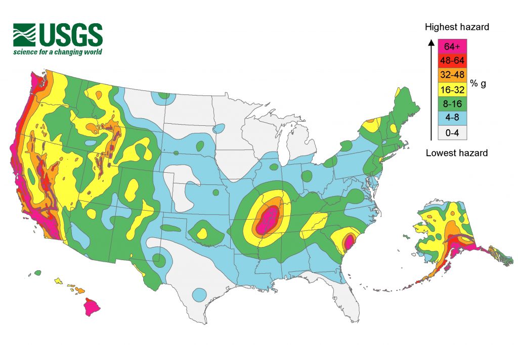
Other strong earthquakes recorded in the continental US were centered in southeastern Missouri near the border with Arkansas, Kentucky and Tennessee.
In the winter of 1811-1812, a series of three powerful earthquakes of magnitudes about 7.0 to 7.8 and hundreds of aftershocks occurred near New Madrid, Missouri.
These shocks were so strong that observers reported that the land distorted into visible rolling waves. They changed the course of the Mississippi River, created a vast area of ground deformation and liquefaction features; and they were felt widely along the east coast of the U.S. 800 to 1000 miles away.
Because the surrounding area was mostly undeveloped at the time, few deaths were reported and these events stirred relatively little attention then.
In August of 1886, a strong earthquake occurred in Charleston, South Carolina. Magnitude is estimated at 6.8 to 7.2. Much of the city of Charleston was damaged or destroyed.
Earthquakes in the East are not confined to these areas; they have been recorded in every State east of the Mississippi. Damaging earthquakes have occurred historically in nearly every eastern State.
Earthquakes of the same magnitude affect larger areas in the East than in the West
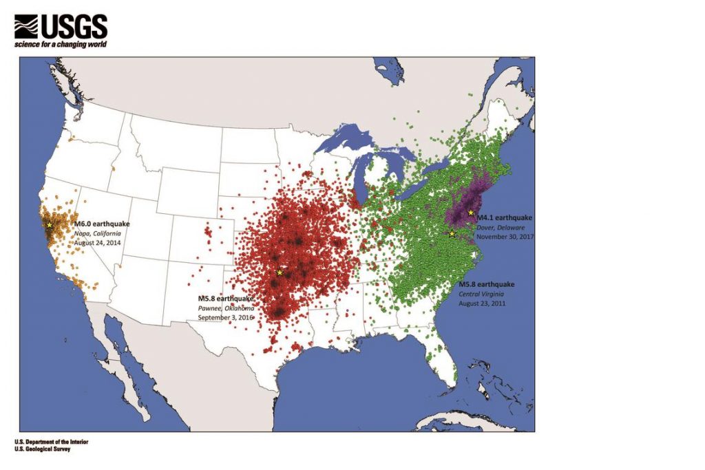
A magnitude 5.8 earthquake in 2011 in Mineral, Virginia, was felt up to 600 miles from the epicenter. Tens of millions of people in the eastern United States and southeastern Canada felt this earthquake.
For comparison, a magnitude 6.0 earthquake in 2014 in Napa, California, was felt only as far as 250 miles from the epicenter. Despite the Napa earthquake releasing about twice as much energy as the Virginia earthquake and causing much more damage near the epicenter, it wasn’t felt nearly as far away.
As another example, the magnitude 4.1 earthquake that occurred in December 2017 near Dover, Delaware, was felt approximately 200 miles from the epicenter. The region that felt this earthquake is about the same size as that of the much larger California event, which released about 700 times more energy.

The size of the geographic area affected by ground shaking depends on the magnitude of the earthquake and the rate at which the amplitudes of body and surface seismic waves decrease as distance from the causative fault increases.
Comparison of the areas affected by the same Modified Mercalli intensity of ground shaking in the 1906 San Francisco, California, the 1971 San Fernando, California, the 1811-12 New Madrid, Missouri, and the 1886 Charleston, South Carolina, earthquakes shows that a given intensity of ground shaking extends over a much larger area in the Eastern United States.
Seismic waves travel farther in the East
Ground shaking affects a larger area because amplitudes of seismic waves decrease more slowly in the east than in the west as distance from the causative fault increases.
Eastern North America has older rocks, some of which formed hundreds of millions of years before those in the West. These older formations have been exposed to extreme pressures and temperatures, making them harder and often denser.
Faults in these older rocks have also had more time to heal, which allows seismic waves to cross them more effectively when an earthquake occurs.
In contrast, rocks in the West are younger and broken up by faults that are often younger and have had less time to heal. So when an earthquake occurs, more of the seismic wave energy is absorbed by the faults and the energy doesn’t spread as efficiently.
Challenges of assessing earthquake hazards in the East
The geology of the eastern United States and the relatively sparse history of earthquakes to study make it difficult for scientists to assess how frequently earthquakes will occur and how large they can be.
Mysterious earthquakes
Eastern earthquakes are more of a mystery because they do not take place at a plate boundary where most other earthquakes originate.
Scientists do not fully understand the state of stress within tectonic plates, and they are studying how stresses accumulate and evolve and how earthquakes are triggered.
Where are the most active faults in the East?
Scientists also do not know precisely where most active faults are located in the East.
Most faults have not had major earthquakes or movement in the past few million years, and the faults that are active may only have earthquakes every few thousand or tens of thousands of years.
Furthermore, any evidence of past earthquakes on the land’s surface in the eastern U.S. is often obscured by vegetation or is more subdued because of erosion.
The New Madrid Seismic Zone is about 30 years overdue for a magnitude 6.3 earthquake. A magnitude 7.6 earthquake, as serious as the 1811-12 series, may arrive by 2069. So my question is… Are you ready? [USGS]
Now subscribe to this blog to get more amazing news curated just for you right in your inbox on a daily basis (here an example of our new newsletter).
You can also follow us on Facebook and/ or Twitter. And, by the way you can also make a donation through Paypal. Thank you!
You should really subscribe to QFiles. You will get very interesting information about strange events around the world.


Sunny had a good post down below. Felt like I was back in Geology class 30 years ago. ?
Seeing as the USGS map doesn’t even show the fault line in New York City, why should I give any credence to them?
Around 2 weeks after the 9/11 attacks in NYC and the Pentagon, a 5.1 magnitude quake struck in the middle of Virginia (I was living in Adelphi, Maryland at the time). George (my partner) and I were in the kitchen, when the houses on our block shook. A neighbor across the street came out and told us it was an earthquake. Boy, was I shaken up by it.
After you go through some 6-7mag quakes, you’ll be used to it, and consider a 5.1mag like a back massage.
Well, one architectural device my father used was called a gerb, made in Germany. They are like a shock absorber. It was one of the first gerb set ups on a residential steel and glass structure.
They probably have people that can start implementing that type of device in earthquake prone areas. Normally they are used commercially. Or, at least that was how things were 30 years ago.
The fact that older rock is more prevalent in the east, and it has not been broken up by regular quakes, is problematic. It sounds like what happens when you snap a thick tree branch. Powerful energy is released, suddenly, and with intensity.
Or build in a ‘stable’ area within that zone. Where I live it is shallow earth and rock. I built with that in mind. Also the whole structure is tied together for shaking! Those in cities like Memphis, Louisville KY, Chicago etc are screwed when the Madrid lets loose. AND big cities farther east – Cincy, Philly, NY, etc – will all have major structural damage. Gonna be a hell of a time!!!
Interesting. Sounds solid, but enough to have wiggle and jiggle room.
Yeah, Madrid will probably be a hard thrashing. I remember watching a film reel on the 1906 S.F. Quake in 1970.
It was black and white, but you could see the massive destruction well enough. I remember it was the subsequent fires that really finished off the demolition.
Please don’t tell me that you believe in that “older rocks” crap. These people are lunatics’ and have nothing like common sense so they make up stories to justify themselves and show how smart they are. Just like their “climate change” and most of their “space theories”.
Well, we do know that small quakes take pressure off. If they break up rock on the plates, then it creates spaces which can take stress down on a bigger quake? Seems like a reasonable hypothesis?
What do you think happens?
?
Appalachia, the mountain chain, is the oldest mountain formation on Planet Earth. And yes in SC KY where I live we won’t have the problem of Liquification and the land acting like the wave’s of the Sea at 2-3ft in height. Look at the buildings in downtown Louisville and anyone in those will be D-E-D dead.
AND the Aquifer UNDER Louisville has been lowered due to drainage for over 100 yrs! Down 50 ft and up and down 2-3 ft…ROCKIN ASS TIME!!!
Yes there are older rocks carbon dated It isn’t the age of the rocks its the age of the faults .They run deep and aren’t easy to study at all .Couple that with the fact many are reverse slip strike and it gets messy Now lets not forget its a karsk region .Some of those earthquakes are old shelves breaking off and settling .Roughly 15 years ago we kept hearing and feeling what we thought was jet maneuvers .It wasn’t, in fact it wasn’t traced to any man made problem .Its my guess that it was a shelf breaking off .Also it would help you to know there are two ancient volcano domes located on the east coast Mole Hill and Trimble Knob.
https://www.thegatewaypundit.com/2021/08/deblasios-nyc-shooter-assassinates-woman-busy-street-quietly-gets-back-car-drives-off-video/
East coast N.Y.
America?
Broad daylight, a woman gets smoked. You stupid lefties want to defund the police. Ha, enjoy the breakdown of a once civil society. That video says it all. That could be somebody’s mother!
https://www.thegatewaypundit.com/2021/08/singer-erykah-badu-posts-video-obamas-maskless-birthday-extravaganza-deletes-watch/
Look at the serpent seeds dancing without masks. Probably had an orgy in goat’s blood afterwards. lolollolllollllolllll