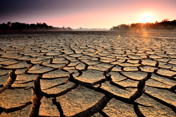
It’s going to take a lot more than one storm to erase the long-term drought across California, but the former bomb cyclone that marched into the West Coast sure did help. While another storm of that magnitude is not expected to slam into the West Coast this upcoming week, there will be multiple rounds of wet weather that will continue to trend things in the right direction.
Many of California’s reservoirs were at historically low levels prior to the arrival of an atmospheric river of moisture between Oct. 24 and Oct. 25. For a short time, Lake Oroville’s hydroelectric power plant had to cease operations due to the low water levels, but thanks to heavy rainfall across the Feather River watershed (the river system that flows into Lake Oroville), the power plant has since reopened.
The amount of water that rushed into Lake Oroville was staggering in the wake of the bomb cyclone, offering hope to some that the drought conditions may ease. Prior to the influx of rain, the lake level stood at 629 feet above sea level, but just 8 days later on Oct. 30, the lake level now stands at 659 feet – a rise of 30 feet in just over a week.
Lake Tahoe also observed a massive influx of water from the recent stormy conditions. Earlier in October, lake levels had fallen below the natural rim, meaning that the lake was no longer connected to its only outlet, the Truckee River. Now, after heavy rain and feet of snow in the mountains, the lake levels have passed about an inch above the natural rim, allowing water to flow into the river.
There’s still a long way to go however, as the lake is considered full when water levels are around 6 feet above the natural rim.
Many other lakes and reservoirs have seen impressive jumps in lake levels, including Folsom Lake which has jumped 19 feet higher, and Lake Shasta – California’s largest reservoir – rose 3 feet after the deluge of rainfall.
California not out of drought
Although the recent rain has been great news for reservoir levels, there’s still a very long way to go in order to ease drought and water-usage concerns.
As shown on the diagram below, although last weekend’s atmospheric river brought record-breaking amounts of rain to drought-plagued California, they didn’t give the state’s water supply much of a boost.
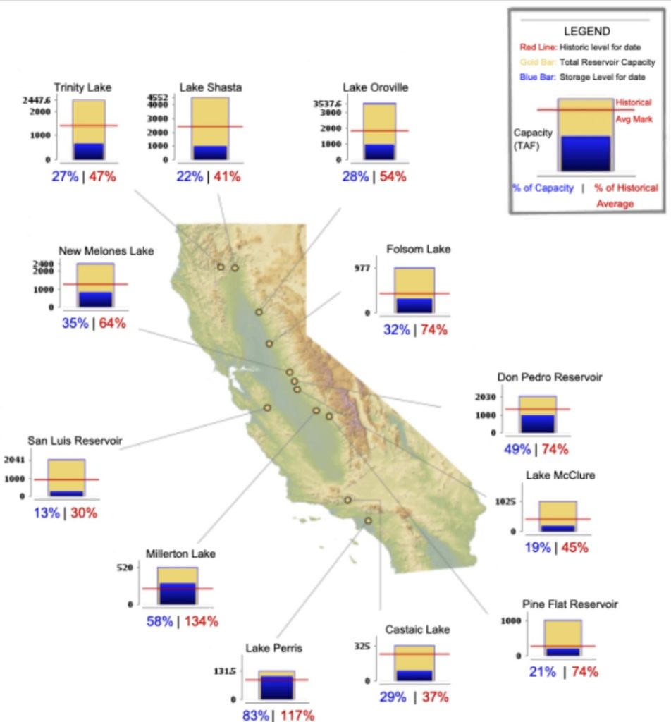
The data shows that, even after all of Sunday and Monday’s rainfall, many of California’s largest reservoirs are still holding less water than the historic level for this time of year.
California’s 240 large reservoirs account for about 60% of the state’s water storage capacity, according to the Public Policy Institute of California.
Outliers include Millerton Lake in Central California and Lake Perris on the southern end of the state — both of which have more water right now than their historic average for Oct. 25.
On the other hand, California’s largest reservoir, Shasta Lake, still has only around 41% of the amount of water it would normally have this time of year, and is at only 22% of its capacity. Lake Oroville, the next largest, is in a similar position — it has 52% of its historic level of water, and is at 27% of its capacity.
While the atmospheric river did add to the state’s overall water supply — Lake Oroville, for example, gained 100,000 acre-feet of water — the persistent lack of water relative to historic levels is a sign that this weekend’s downpour was still not enough to correct years of drought.
You should really watch the documentary film: Megadrought – Vanishing Water and prepare accordingly!
Some new storms ahead
Luckily, this upcoming week will feature additional chances for rain and mountain snow along the West coast.
Monday will bring along the first round of rain and mountain snow to the West Coast as a storm will be set to trek inland. Appreciable rainfall will generally be limited to the San Francisco Bay Area and points north from this storm, leaving the remainder of Central and Southern California dry.
Wet weather will work its way inland throughout the day on Monday, expanding along the Interstate 5 corridor from Northern California up through Washington State. Along the route, cities like Medford, Eugene, Salem and Portland, Oregon, can expect a wet commute as the storm passes by.
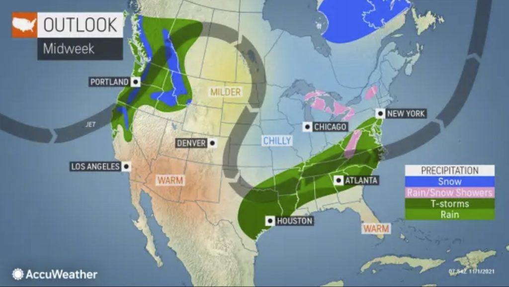
Rainfall will not be nearly as heavy as the bomb cyclone a week or so ago, but a general 0.50 of an inch to perhaps up to 2 inches of rain can fall across the coastal ranges of Northern California by the time wet weather tapers off and shifts inland Tuesday morning.
A majority of the wet and wintry weather will shift into the Intermountain West by Tuesday, bringing along another fresh coating of snow for the mountainous terrain of the central Rockies.
Conditions may reach winter weather advisory criteria in places like Yellowstone National Park, Grand Teton National Park, Utah’s Uinta Mountains and across the mountains of northern Colorado. Any hazardous conditions should remain rather brief in these places, as dry weather is expected Wednesday as an area of high pressure builds in.
It won’t take long for another storm to target the West Coast this upcoming week, as another, potentially more potent disturbance is expected to roll in late Wednesday into Thursday.
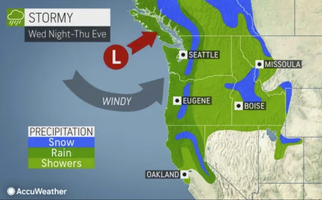
This will likely target many of the same areas as the early-week storm, generally from Central California and points north.
Seasonal drought outlook
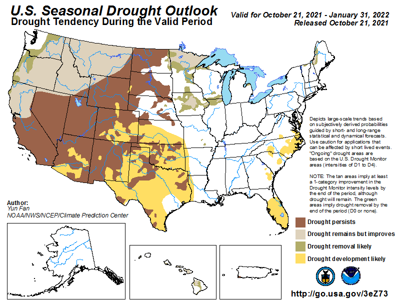
La Niña conditions have developed and are expected to continue with an 87% chance of La Niña during the Northern Hemisphere winter 2021-22. Drought continues entrenched across much of the West and Northern Plains, as well as parts of the Midwest.
The West Coast and Northern Rockies also saw deterioration over the late summer months. Conversely, the Southwest has experienced remarkable improvements to drought conditions in the months leading up to the NDJ season due to a robust North American Summer Monsoon.
Entering into a climatologically wetter season for much of the West, coupled with the development of La Niña conditions, increases chances for improving drought conditions across the Pacific Northwest and Northern Rockies.
Although high soil moisture is expected to be present at the beginning of the period across portions of the Four Corners Region, a warmer and drier signal predicted across the region due to the development of La Niña increases the chance of drought redevelopment across parts of Arizona and New Mexico.
The Great Plains and Midwest represent an area of transition with drought persistence likely for western areas and improvement is possible for eastern areas. Farther to the west, given ongoing drought and lack of precipitation signals, drought persistence is favored for the Northern Plains.
Farther south, above-normal temperatures and below-normal precipitation favored throughout NDJ increase odds for widespread development across the Central and Southern Plains.
Precipitation signals are near to above-normal over the Great Lakes through the season, and temperatures are expected to remain above-normal. With diminishing evaporation and evapotranspiration rates during NDJ, short-term improvements are favored for parts of the Midwest.
Since above-normal precipitation is favored during the NDJ season across ongoing drought areas of the Northeast, improving drought conditions are most likely. The Southeast is drought free currently. However, below normal precipitation and above normal temperatures are favored across the region due to the influence of La Niña.
Therefore, chances of drought redevelopment are increased over the current dry areas in the Carolinas and drought development is likely over the central and southern Florida Peninsula.
Alaska will likely remain drought-free, entering into the winter months with a wet climatology along the southern coast. Hawaii is expected to experience at least some drought improvement as they head into a climatologically wetter time of year, coupled with predicted near to above normal precipitation. Drought persistence is favored for Puerto Rico as the region heads into its climatologically drier season and a forecast favoring near to below normal rainfall in the outlook period.
[AccuWeather, drought monitor]
Now subscribe to this blog to get more amazing news curated just for you right in your inbox on a daily basis (here an example of our new newsletter).
You can also follow us on Facebook and/ or Twitter. And, by the way you can also make a donation through Paypal. Thank you!
You should really subscribe to QFiles. You will get very interesting information about strange events around the world.



When are you morons going to sink that HAARP focussing barge moved down from Seattle to anchor 1,000 miles out from Eureka to deflect moisture laden Pacific Ocean air toward the south and Mexico? I watched the barge being relocated there after it pulled anchor and split from Seattle. About 10 years ago. Look up the dates and PHOTOGRAPHS and then study the U.S. Weather Satellite raw feeds, where you can actually SEE WITH YOUR OWN EYES that ALL OF THIS has been going on, uninterrupted for over 10 years. Just like the ‘California drought’. Duh.
One storm will not end so many years of Drought. But it may indicate a change in the weather cycle and over time that would end it.
We also will not see the additional amounts of moisture that fell as snow, until Spring.
So the article may be a bit premature and it’s facts and figures are not complete until after the Spring thaw hits.
See my above comment about the HAARP barge. I kid you not. I swear, under oath, to this.
https://iconnectfx.com/ERFx/Videos.aspx?mc=0
many videos that Youtube is censores are here free and freely.
Youtube is 1984 and soon will come we can not write or talk freely. So let it be today we can we talk so we do not alas of yesterday!
I told you get out of big cities now it does really make sense. News before it happens. We sent our warning documented here how many times i said get out of big cities now now you must go through third shaking of planet , quakes, with volcanoes, floods and tornadoes now is up on you all west coast to east coast and all over the ring of fire.
Fauci Isn’t the Only Sadistic Bastard
WARNING: Photos are horrible but the truth must be told and seen
Back on August 16, 2021, I pointed out in my column: “There is NO need to abuse animals and subject them to extreme pain and cruelty to sell products (like spraying hair spray into the eyes of a bunny rabbit to see how the poor thing will react) and certainly not this but then again, I see Doctor Death as having no soul: Anthony Fauci Approved the Systematic Torture of Dogs (8.5.21) – $424,000 of our tax dollars. Beagles were tortured and endured months of horrible pain and then killed.”
Desalinization plants should also be considered, so water supply issues aren’t panicking people.
Stop letting good water flow out to the Ocean and build many, many more reservoirs.
That will cure the problem that Californians live in a DESERT!
Yep, and even electroverse is saying we are due for heavy Winter snowfall.
It will probably be normal soon. Worry about food supply, and stock up. Mike, you agree?