After 16 days of relentless Pacific storms, including a bomb cyclone, and a constant stream of atmospheric rivers, most of the Bay Area is slated to see a comfortable break in the wet pattern Thursday.
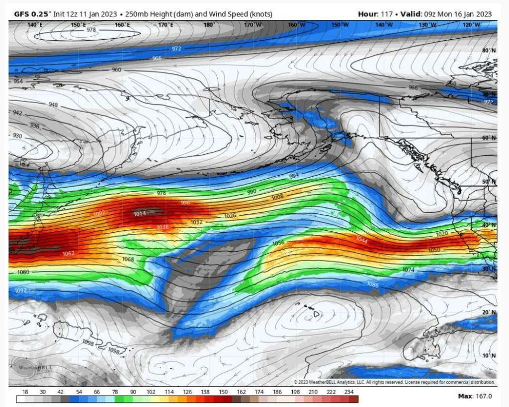
This is thanks to a shift in the flow of air thousands of feet above the ground — the jet stream — its winds gradually shifting north in the coming days, meaning the storm door will finally begin to close.
KEEP STRANGE SOUNDS ONLINE FUNDRAISER! THANK YOU FOR HELPING!
But before it does, two more storms will roll into far Northern California this weekend and into early next week. Some of the rain and snow will spill into the rest of the Golden State, raising the risk for light to moderate bands of rain in areas that are filled to the brim from all the recent storms.

A storm door that just won’t shut
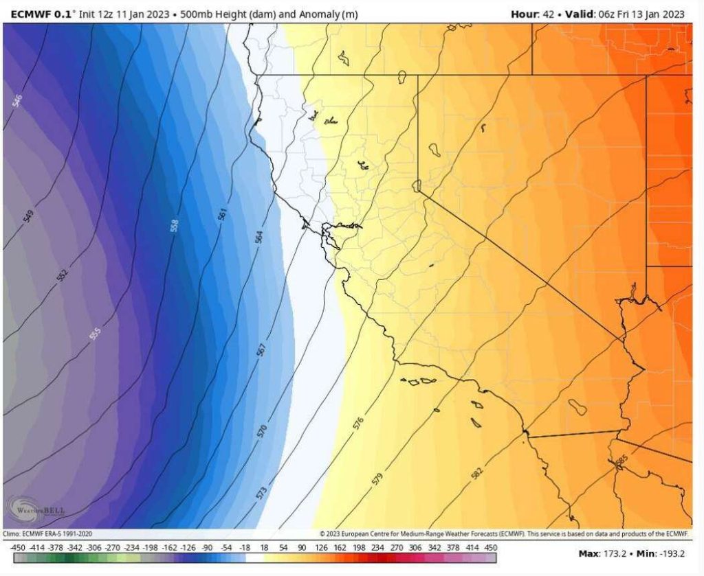
Thursday’s shift in the jet stream has some far-reaching implications to the overall weather pattern in the Bay Area and much of California. Its tilt farther north will send atmospheric rivers into Eureka and the Oregon coast, rather than the Bay Area and Southern California. The last time the core of atmospheric rivers made landfall that far north was in mid-December, when most of the Bay Area was just starting to see brief rounds of moderate rain.
This shift in the jet stream’s flow is causing a weather pattern that resembles mid-December’s flow of moisture.

This means that as we head into Friday night and Saturday, when the next Pacific storm is set to roll into California, the system will have less moisture to work with than previous ones. The rest of the ingredients for a rainy weekend — convective energy, lift from the mountains and weather fronts and instability from the storm — will be there. But moisture levels will be lacking.
KEEP STRANGE SOUNDS ONLINE FUNDRAISER! THANK YOU FOR HELPING!
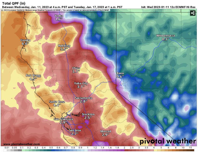
That’s not to say that there won’t be a lot of rainfall. Totals for the storm on Friday night and Saturday will run at around 1 to 2 inches for the Bay Area and 2½ to 3 inches for higher elevations. By Sunday night into Tuesday, the next storm will bring similar totals. There will be around 2 to 5 inches of rainfall accumulated across the Bay Area by Tuesday.
That’s a far cry from the rainfall the bomb cyclone and the New Year’s Eve storm brought to the region. And while these numbers are still impressive for this time of the year, the fact that it’s going to take two storms to reach values that a single storm was able to generate just a couple days ago is a sign that the shift to a drier pattern is right around the corner.

Floodwaters will take some time to recede
Looking at the accumulated rainfall that fell during the last three weeks and forecast rainfall expected in the next week as a bell curve, rainfall is currently trending downward. As the jet stream continues to tilt farther north, the storm door will continue to close until it finally shuts sometime during the third and fourth week of January.
But until then, weak storms will bring light to moderate rains that make it difficult for water levels in rivers and streams to recede. This includes the Russian River, San Lorenzo and several other waterways in the Bay Area and the rest of the state that will need a couple weeks to fall back down to normal levels. And until the storm door completely shuts, it’s going to take some time to air out all the excess water from this incredible display of atmospheric rivers and storms that California endured at the start of 2023.
Thursday breakdown
San Francisco: For the first time in several days, mostly cloudy weather will give way to a fair share of sunshine across the city today. The air will remain warm and humid this afternoon as temperatures rise to the lower 60s in the Sunset and Richmond districts, the Presidio, Golden Gate Park and Lake Merced. Muni commuters from West Portal to downtown will notice a bit more of a warm-up as temperatures east of Sutro Tower are slated to reach the mid-60s. This mild, tropical-like air will stem from a distant storm off the coast. This comfortable weather will be a nice reprieve from the platitudinous dispensations of rainfall over the past couple of weeks. Unfortunately, the storm door isn’t completely shut just yet, as drizzles return to Ocean Beach, the Embarcadero and Hunters Point tonight.
Pacific Coast and Peninsula: Moisture-laden air will filter into all corners of the Peninsula this afternoon, raising temperatures along Highway 1 between Pacifica and Half Moon Bay to the lower 60s. Mostly cloudy skies, brief rounds of sunshine and humidity levels near 90% will make it feel a bit tropical along the coast this afternoon. This warm, moist air will stream east of Highway 92 into South San Francisco, Daly City, Millbrae and San Francisco International Airport by the afternoon hours, raising daytime highs to the mid-60s by the bay. The rest of the Peninsula, including Redwood City, Foster City and Atherton, can expect warm air and rounds of sunshine as well this afternoon as the region enjoys a nice break from the recent rains.
KEEP STRANGE SOUNDS ONLINE FUNDRAISER! THANK YOU FOR HELPING!
North Bay: The tail end of an atmospheric river off the coast will seep into the northernmost stretches of Marin, Sonoma, Napa and Solano counties today. Look for warm, tropical-like air, high humidity levels and rounds of sunshine from mostly cloudy skies. Daytime highs in Santa Rosa, Napa and Petaluma will reach the mid-60s this afternoon, while a light breeze off San Pablo Bay and the delta will keep most of Marin and Solano counties in the lower 60s. Residents should watch for any ponding and isolated flooding on Highways 29 and 101 since rivers are already swollen from this spate of storms. The Russian River and several other streams in the area are still running high near towns like Guerneville and Healdsburg, so plan for any alternate route suggestions from local authorities if floodwaters begin to rise again.
There is a slight chance for intermittent rain showers in the Mayacamas Mountains and just north of Santa Rosa today, but most of these will be brief.
East Bay: Warm, moist air will hover over Contra Costa and Alameda counties today, raising mostly cloudy skies that allow some sunshine to filter in this afternoon. Look for mostly quiet weather for residents east of I-680, including Walnut Creek, Antioch and Brentwood. The San Ramon and Livermore valleys will likely see their fair share of sunshine today while a light delta breeze keeps daytime highs in the lower 60s.
Warm air will seep into San Francisco Bay during the day. This will help raise temperatures in Alameda, downtown Oakland and most of the I-80/I-880 corridor to the mid-60s. Residents in the Oakland and Berkeley foothills, including Piedmont, Albany and Castro Valley, will see some of their standing floodwater recede today, but be sure to watch for any pockets of ponding and closed-off roads thanks to recent landslides.
South Bay and Santa Cruz: River levels continue to slowly recede on the San Lorenzo River, streams and creeks near Highway 17 today. Humid air and mostly cloudy skies will make for a more comfortable afternoon with daytime highs in the lower 60s. The intermittent sunshine will help speed up the evaporation of floodwaters and dry out some of the soils along the CZU burn scar.
Rounds of sunshine will raise temperatures in the Santa Clara Valley to the lower to mid-60s this afternoon, while floodwaters on stretches of 280 and the 101 corridor between Morgan Hill and Gilroy will continue receding.
KEEP STRANGE SOUNDS ONLINE FUNDRAISER! THANK YOU FOR HELPING!


Holy crap! Hopefully everyone is fine and there’s no lasting infrastructure damage.
We had a storm up in Northern California when I was in boarding school. Way back in 1974-75. We had 3″ of snow on the ground. School was closed, and we decided to have a snowball war with our favorite girl’s Catholic school up the street.
That was unusual weather. Storms with pounding rain were normal, as was the morning mist you needed a knife to cut through.
This storm(s) is a blessing in disguise. It kills the drought hoax. Replenishes the nitrogen in the soil for the trees and plants, freshens up the air, and hopefully fills up the reservoirs.
About the drought…
The hoax evaporated into thin air.
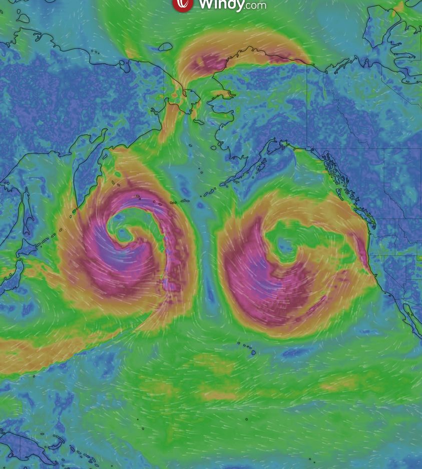
two bomb cyclones looks like two huge t”ts .. God save all from t”ts
Hahaha, those geoengineered pedo symbols.
Jeremiah 10:15 KJV
They are worthless, the objects of mockery; when their judgment comes, they will perish.
God almighty will allow satan and followers (science, pharma, gov leaders ect. ) only a short time to harm us for our iniquity. As in the days of Noah,
Genesis 6:5 KJV
5 And God saw that the wickedness of man was great in the earth, and that every imagination of the thoughts of his heart was only evil continually.
Yeah, fossil records prove “climate change”, which is due to our sins, then came the flood. however berGOGlio and WEFers will use this to futher their evil agenda. The pale horse is riding, chloros Green horse/ Green Agenda. We know this is agenda 2021/ 2030 already in effect.
The earth is the Lord’s, and the fullness thereof.
That was very superlative, Thomas. Cheered me up.
The full Moon Wolf caused all this plus HAARP and also California giving every black 300,000 retributions so why they want give pay out like that ? So full third shaking of planet is in full motion with 7.5 quakes plus hit California and of course a series of it to Vancouver Canada?
Medical Martial Law Coming to Your State? Here’s What You Need to Know
Although stopped for now in New York state, shockingly, this regulatory framework has already passed into law in Florida, Alaska, and Washington state, which have all adopted the “Turning Point” model legislation. Similar initiatives are making their way state by state, and are in various stages of the legislative process.
Today’s Whistleblower Report documents the legal framework and plans going back decades for a militarized medical martial law that is being put into place under the cloak of secrecy in states across America. Attorney Bobbi Anne Cox, Esq. is a courageous legal warrior who succeeded in winning a major legal victory to stop the highly secret, totally unconstitutional forced quarantine indefinite detention regulation promulgated by New York Governor Hochul and her appointed Department of Health Director.
International attorney Todd Callender, Esq. provides the legal framework for all of these draconian quarantine detention measures that began in the 1994 Cairo Population Accords and the steps to achieve a global reduction in population using a militarized medical martial law and the declaration of a “public health emergency of international concern.” Then almost ten years later, the “Turning Point” model legislation was developed, giving all 50 states a blueprint to implement these forced detentions, ostensibly for “quarantine” to prevent the spread of “communicable diseases.”
https://www.truthforhealth.org/2022/09/medical-martial-law-coming-to-your-state-heres-what-you-need-to-know/
For quite some time it has been my belief that when the snowpack and water table are well saturated, this puts stress on the fault lines. Especially if there is expansion and contraction of soil when it gets warmer.
I am going on record to say we will probably see a major quake in the very near future for the left coast.
I have lived in California for 70 years. This is just part of the deal. It’s a wet winter. Get over it.
Exactly Bill. Having lived through 60’s through 80’s it is just another good wet season. Surprised there isn’t more cheers for the rain to compliment the drought fear propaganda?
Yes. Many of us seem to have some expectation or entitlement to be “safe”, walking around lost with umbilical cord in hand looking for a place to plug it in. This thinking makes everything a potential hazard that needs to be done away with. That is the “climate change” mentality in a nutshell. And I do mean nut.
??
In southeast Alaska These storms are what usually hit us constantly throughout the fall and winter. Weird to see them so far south. We are bearly getting snow and its been an unusually dry winter. Where our summer was unusually wet. The climate is changing, thanks to the sun.
Earth Wobble.
Thanks to the sun indeed, and the weakening magnetosphere causing the jet streams to travel outside their “measured” trajectory. We are in meteorological and geological times never seen by living man. It’s all so very interesting and exciting to witness.
oh no. weather.
This is God. Stop giving glory to man.
“They refused to repent and give glory to GOD”
This isn’t God’s doing,you can blame good ole Joe for this. This weather is totally man made by Russian Geoengineers due to him giving Ukraine all the weapons that are used to kill Russians. They hit Florida last summer and now they are hitting California.I guess it’s better than being nuked.Just wish they would rain on DC.Oh,earthquakes are next.
Damn Russians again!
You always say that. If God were to pour his Wrath out, it would be much more dramatic. Besides he will not use flooding as he promised. Let’s not be silly.
fire and hail, snow and mist,
stormy wind fulfilling his word!
—Psalm 148:8
So, California needs water? Look at it as a Blessing?
More rain and snow is good for the water table. Hopefully, this will stifle in blizzard of climate alarmist baloney.
Stifle the/ typo