America is basically a cracked dinner plate we keep eating off of. The U.S. is indeed crisscrossed by dangerous faults, but not all regions are equally at risk. If you don’t believe me, just look at the USA earthquake fault map below, featuring the probability of damaging shaking over the next 100 years:
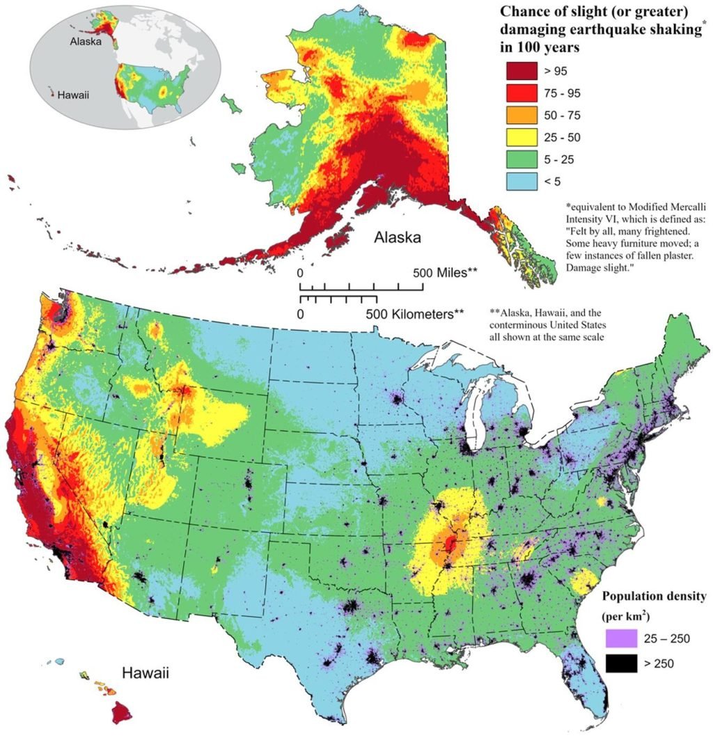
The West Coast is a tectonic knife fight (Cascadia, San Andreas, Hayward), the country’s middle hides a quiet bruiser (New Madrid), the Northeast pretends it’s fine (Ramapo… hello), and the Seattle metro sits atop tangled zippers (Seattle Fault, Tacoma Fault, South Whidbey Island Fault). If you live near any of these, you don’t need panic—you need a plan.
Now, it’s time to dive into the most dangerous earthquake fault zones in the USA (also called seismic hazard zones)—the ones that keep scientists awake at night and should probably keep you awake too.
America’s Seismic Big Picture
Seismic hazard maps show where are earthquakes most likely in US. The West Coast is glowing like a radioactive Christmas tree, but don’t be fooled: the middle of the country hides a sleeping giant, and even the Northeast has fault zones threading under major cities. The rule is simple: it’s not if you’ll shake, but how hard and for how long.
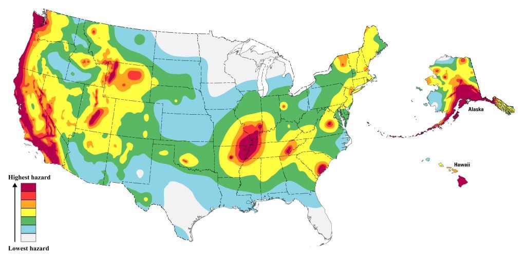
So if you thought earthquakes were just a California problem, this probability earthquake map proves otherwise. The Midwest? Check again. The East Coast? Yep. Alaska? Off the charts. Now let’s describe the most dangerous fault lines and zones in America from West to East.
West Coast Boss Level
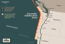
🌊 Cascadia Subduction Zone
The megathrust of nightmares, stretching from Northern California to Vancouver Island.

Last time it went big (year 1700), it sent an “orphan tsunami” all the way to Japan.
Scientists say it’s capable of a magnitude-9 quake with four minutes of ground roll and a wall of water to follow. Sleep tight, Pacific Northwest.
Funny/terrifying fact: When Cascadia goes, your coffee won’t just spill — your entire coastline may suddenly jump a few meters. Some scientists even carry personal go-bags to conferences in Portland. Not suspicious at all.
💡 Prep Tip: If you live on the coast, know your tsunami evacuation route like you know your Netflix password.
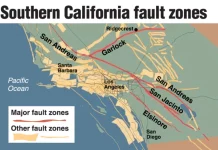
🌉 San Andreas Fault
California’s red-carpet celebrity (it’s in movies, songs, video games), the San Andreas Fault runs 800 miles through California, slices the state in two and loves to hog the headlines.

The south section of the fault hasn’t ruptured in over 300 years — geologists call this a “loaded spring.” Californians call it “Tuesday.” While not the only dangerous fault in CA, its long-quiet southern section has scientists nervously checking their watches.
Weird fact: The San Andreas is actually not the biggest quake risk in California anymore — the Hayward Fault is stealing its thunder.
💡 Prep Tip: If you live near San Andreas, keep shoes by the bed. Most quake injuries are from broken glass, not falling into giant Hollywood movie cracks.
☕ Hayward Fault
Running right through Oakland, Berkeley, and Fremont – hello, expensive real estate! – the Hayward Fault is often called “the most dangerous fault in America.”

Why? Because it’s fully loaded and sitting under millions of people, expensive homes, and artisanal sourdough bakeries. It could unleash a magnitude 7+ right under tech HQs and overpriced coffee shops.
Funny fact: Some BART tunnels and water mains literally cross the Hayward Fault. In an earthquake, that means instant “subway slip n’ slide.”
💡 Prep Tip: If you’re a Bay Area resident, keep a bike. After a big one, freeways, bridges, and BART may be toast.
By the way, here’s a list of the 10 deadliest earthquakes in the US.
The Middle’s Quiet Monster
🌊 New Madrid Seismic Zone
In 1811–12, a series of quakes here made the Mississippi River run backward. (Yes, really.)… And aftershocks rang church bells in Boston.

Today? 45 million people live in its shake zone, including Memphis and St. Louis that sit right on top. A repeat would be catastrophic for America’s central infrastructure—bridges, pipelines, highways, and your Amazon packages.
Weird fact: Chickens reportedly stopped laying eggs during the 1812 quake sequence. Imagine explaining that to a farmer: “Sorry, your hens are tectonically stressed.”
💡 Prep Tip: If you’re in the Midwest, secure propane tanks and fuel lines — they caused most fires in the 19th-century quakes.
The Northeast’s Polite Problems
🏙 Ramapo Fault Zone
The Ramapo Fault Zone stretches across Pennsylvania, New Jersey, and New York.

The East Coast fault is not famous for monster quakes and probably will never spit out magnitude-9s (Never say Never…), but it does snake under some of the most urbanized corridors and densest population centers in America—including near New York City. Even a moderate M5 here could cause billions in damage — and a week of subway memes or even a more dramatic “Wall Street panic” that isn’t stock-related.
Funny fact: The Ramapo Fault creeps under Yankee Stadium territory. Imagine the headlines: “Bronx Bombers Cancelled by Real Bomb.”
💡 Prep Tip: East Coasters: don’t laugh at Californians. Your buildings aren’t designed for shaking — so even a modest quake can hit harder.
Seattle’s Tectonic Cat’s Cradle
Seattle isn’t just waiting for Cascadia offshore. It sits on a tangle of active local faults:
-
Seattle Fault Zone – Runs east-west right under downtown.
-
Tacoma Fault – To the south, capable of big shakes and tsunamis in Puget Sound.
-
South Whidbey Island Fault (SWIF) – Long, complex, mysterious and nasty, running across the region toward Everett.

These combine into a triple-threat cocktail: shallow local quakes (short and violent), deep slab quakes (long and widespread), and the Cascadia megathrust lurking offshore. The Emerald City’s glass towers? Consider them tectonic Jenga pieces.
Scary fact: The 900 A.D. quake on the Seattle Fault uplifted the shoreline at Alki Point by 20 feet. Imagine waking up to find your beach suddenly a cliff.
💡 Prep Tip: If you’re in Seattle, bolt your bookshelves, because when the “Big One” comes, your $5 lattes won’t be the only thing spilling.
Alaska: Just Showing Off
The 1964 Good Friday quake (M9.2) was the largest ever recorded in the U.S.

Entire towns shifted, land rose by 30 feet in some places, sank in others, and coastlines were rewritten. Alaskans don’t ask if—they just nod when the ground moves.
Meanwhile, they treat magnitude 6s like weather reports: “Oh, that again.”
So… What Can You Do Before the Ground Decides to Rearrange Your Life?
-
Stock supplies: Water, food, meds, batteries, shoes for 3-14 days.
-
Think cash: ATMs die when power dies.
-
Secure your space: Strap water heaters, anchor shelves, latch cabinets.
-
Have a plan: Out-of-area contact, meet-up spots, drills.
-
Know your building: Is it retrofitted? Brick? Soft-story? You’ll want to find out before the shaking.
-
Practice: Drop, Cover, Hold On. (and no, running outside is not heroic, it’s Darwinian). Then check gas, check neighbors, don’t clog 911 with “was that an earthquake?” calls.
-
Don’t believe Hollywood: The ground doesn’t crack open and swallow you. It just shakes everything you love.

FAQ: Because You’ll Ask Anyway
What are the most dangerous fault lines in the USA?
Cascadia, San Andreas, Hayward, New Madrid, Ramapo, and Seattle’s local faults are the top contenders.
Which US states have the highest earthquake risk?
California, Washington, Oregon, Alaska, Missouri, Tennessee, Arkansas, and even New York/New Jersey.
Where will the next big earthquake strike in the US?
No one knows. Cascadia and Hayward are favorites among scientists, but New Madrid and Seattle are also high-risk.
Which fault is “worst”?
Depends: Cascadia is the most catastrophic, San Andreas the most famous, Hayward the most urban, New Madrid the widest, Ramapo the sneakiest, and Seattle the most tangled.
Is the East Coast safe?
Not really. Fewer quakes, yes, but when they do hit, the old, rigid crust transmits shaking much farther.
Is Seattle overdue?
Overdue isn’t a thing in geology—but yes, the risk is significant in our lifetimes.
The Ground Is Plotting
From Alaska to New Jersey, America’s ground isn’t stable—it’s scheming. The only real question is: will you be the person watching your bookshelves topple in horror, or the one sipping bottled water with a flashlight in hand thinking, “Strange Sounds warned me”?
👉 Subscribe for FREE to the Strange Sounds Newsletter for your daily apocalyptic appetizer. Free dread, with a side of survival tips.
And, by the way, if you want, help fuel the weirdness. You can chip in via PayPal or the DonorBox (Credit/Debit Cards accepted). Every little bit keeps StrangeSounds strange—and unstoppable.


