There’s a new hazard in the Heartland: Man-made earthquake!
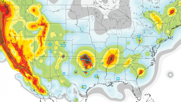
The U.S. Geological Survey (USGS) recently released a map highlighting the future risk for man-made earthquakes, and up to eight states have an increased chance to see ground shaking.
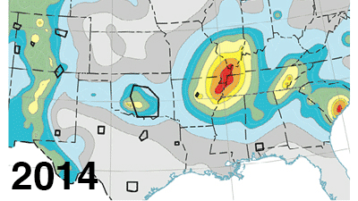
In particular, a new corridor spanning from north Texas to southern Kansas stands out in bright red.
Azle, Texas, which had no recorded quakes for 150 years, felt 27 tremors from November 2013 to January 2014. The Dallas-Fort Worth Metroplex continues to feel regular earthquakes.
As Science Magazine reports, earthquakes hit areas of Kansas bordering Oklahoma 192 times in the last two years; the same counties were only hit twice in the preceding 35 years.
For the most part, the scientific community has already reached a consensus that oil and gas operations, more specifically underground wastewater injections, are causing the swarm of earthquakes down the middle of the country.
These types of earthquakes are non-tectonic and independent of large-scale subterranean movement. Rather, earthquakes like the hundreds cropping up over the last couple years result from the disposal of oil and gas byproducts into the ground.
This new report describes for the first time how injection-induced earthquakes can be incorporated into U.S. seismic hazard maps. These earthquakes are occurring at a higher rate than ever before and pose a much greater risk to people living nearby.
If you live in Texas, Kansas, Oklahoma, New Mexico, Ohio, Alabama or Arkansas, the USGS has offered a clear warning that you’ll feel induced earthquakes.


[…] Look at this new map of the earthquake hazards in the US. […]
[…] The trend is clear. There is a new hazard in Oklahoma: man-made earthquakes. […]
[…] Fracking or New Madrid waking up? […]