

EARTHQUAKE SCIENCE · PLATE BOUNDARIES · ACTIVE FAULTS
Earthquakes are not distributed randomly across the planet. Most occur within narrow belts where tectonic plates collide, separate or slide past one another, while others strike deep inside continents, beneath volcanic regions or along ancient faults that appear quiet until stress reactivates them.
This guide explains the major tectonic environments that generate earthquakes, from subduction-zone megathrusts and continental collision belts to transform faults, rifts, intraplate seismic zones and volcanic hotspots. It also explores some of the world’s most important active fault systems, including the Japan Trench, Nankai Trough, Aleutian Trench, Peru–Chile Trench, Sunda Trench, Hikurangi Margin, North Anatolian Fault, Alpine Fault and Queen Charlotte Fault.
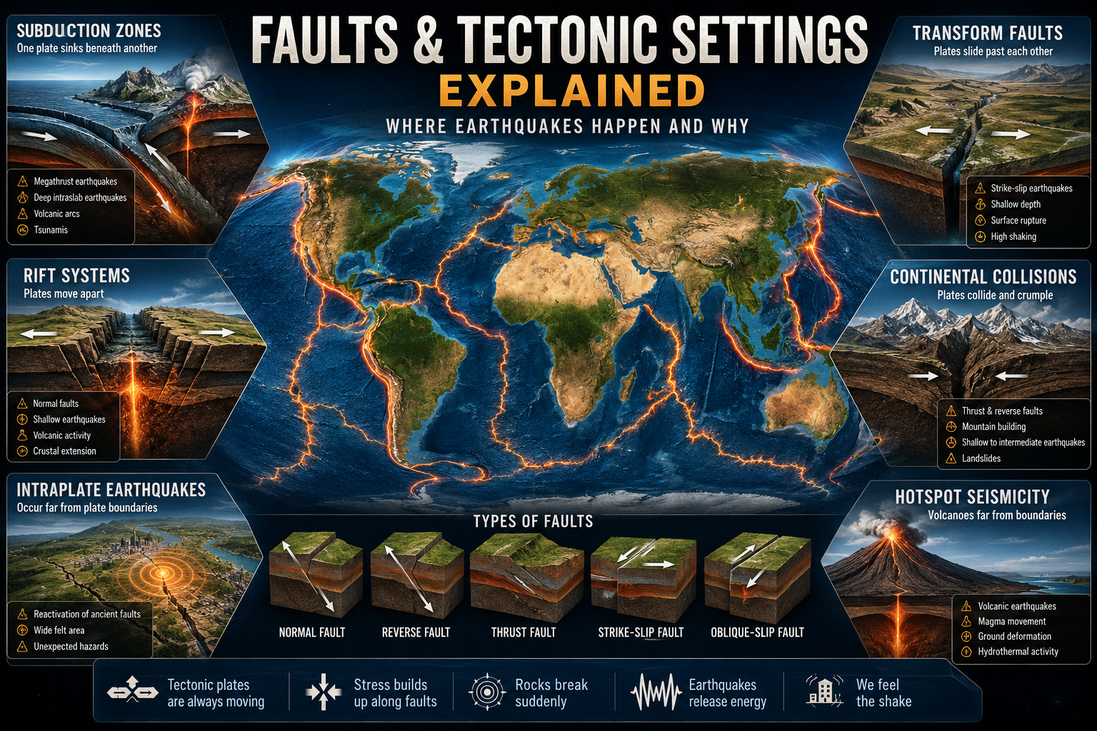
Faults and Tectonic Settings: The Short Version
Subduction zones
One tectonic plate descends beneath another, producing megathrust earthquakes, deep intraslab earthquakes, volcanic arcs and destructive tsunamis.
Transform faults
Plates or crustal blocks slide horizontally past one another, producing shallow strike-slip earthquakes that can rupture rapidly over long distances.
Collision zones
Continents converge without easily subducting, shortening and thickening the crust while creating mountain belts, thrust faults and widespread seismicity.
Rift zones
The crust stretches, thins and fractures along normal faults as continents or oceanic plates pull apart.
Intraplate regions
Earthquakes occur far from active plate boundaries when old faults, crustal weaknesses or regional stress fields become reactivated.
Hotspots and volcanic systems
Magma movement, caldera deformation, hydrothermal pressure and regional tectonic stress generate earthquakes beneath volcanic provinces.
What Is a Geological Fault?
A geological fault is a fracture or zone of fractures within the Earth’s crust along which blocks of rock have moved relative to one another. Some faults are tiny and affect only a small outcrop. Others extend for hundreds or thousands of kilometers and form major boundaries between tectonic plates.
Faults do not necessarily move continuously. Many remain locked by friction while tectonic forces continue to deform the surrounding crust. Stress accumulates until the fault can no longer remain locked. The rocks then slip suddenly, releasing stored elastic energy as seismic waves.
This abrupt movement is an earthquake. The rupture may involve only a small patch of a fault or propagate across a much larger section. Earthquake magnitude depends on the area that ruptures, the amount of slip and the strength of the rocks involved.
The Main Types of Faults
Faults are classified according to the direction in which the rocks move. The three basic categories are normal faults, reverse or thrust faults and strike-slip faults. Many real faults combine more than one type of motion.
Normal faults
Normal faults form where the crust is being stretched. The block above the inclined fault plane moves downward relative to the block below it.
These faults dominate continental rifts, volcanic spreading zones and many regions of crustal extension.
Reverse faults
Reverse faults form where the crust is being compressed. The block above the fault plane moves upward relative to the block below it.
They occur in collision zones, subduction margins and compressed mountain belts.
Thrust faults
Thrust faults are low-angle reverse faults capable of transporting huge slabs of crust over one another.
Megathrust faults at subduction zones are the largest thrust-fault systems on Earth.
Strike-slip faults
Strike-slip faults accommodate predominantly horizontal movement. The blocks slide sideways past each other with limited vertical displacement.
Major examples include the San Andreas, North Anatolian and Alpine faults.
Oblique-slip faults
Oblique-slip faults combine horizontal movement with compression or extension.
They are common where plate motion approaches a boundary at an angle rather than directly across it.
Blind faults
Blind faults do not reach the surface and may remain hidden beneath sediment, cities or folded rock.
Their lack of obvious surface expression can make seismic hazards harder to recognize.
Where Earthquakes Occur: The Major Tectonic Settings
The global pattern of earthquakes reflects the movement of rigid tectonic plates over the weaker asthenosphere. Most seismicity occurs along plate boundaries, but the style, depth and potential magnitude of earthquakes vary dramatically from one setting to another.
| Tectonic setting | Dominant motion | Typical fault style | Earthquake depth | Principal hazards |
|---|---|---|---|---|
| Subduction zone | Convergence | Megathrust, reverse, normal, intraslab | Shallow to nearly 700 km | Extreme shaking, tsunami, landslides, liquefaction |
| Continental collision | Compression and crustal shortening | Thrust, reverse, strike-slip | Mainly shallow to intermediate | Mountain landslides, surface rupture, basin amplification |
| Transform boundary | Horizontal shear | Strike-slip and oblique-slip | Mainly shallow | Surface rupture, intense shaking, infrastructure displacement |
| Continental rift | Extension | Normal and oblique-normal | Mainly shallow | Fault scarps, landslides, volcanic unrest |
| Mid-ocean ridge | Seafloor spreading | Normal and transform | Shallow | Mostly submarine shaking, seafloor deformation |
| Intraplate region | Regional stress acting on old weaknesses | Variable | Usually shallow | Wide-area shaking, unexpected infrastructure damage |
| Hotspot or volcanic system | Magma, fluids, collapse and regional tectonics | Normal, ring fault, strike-slip or mixed | Usually shallow | Earthquake swarms, ground deformation, volcanic hazards |
Subduction Zones: Earth’s Largest Earthquake Factories
Subduction zones form where one tectonic plate sinks beneath another. The descending plate is usually dense oceanic lithosphere, while the overriding plate may be oceanic or continental.
The contact between the two plates is called the megathrust. Portions of this enormous fault may remain locked for decades or centuries as plate motion continues. When a locked segment finally ruptures, it can produce an earthquake exceeding magnitude 8 or even magnitude 9.
Subduction zones are more complicated than a single fault surface. Earthquakes may occur:
- On the plate-boundary megathrust.
- Within the descending slab.
- Inside the overriding plate.
- Near the oceanic trench in the outer-rise region.
- Along faults within the volcanic arc.
- At intermediate and deep levels inside the subducted plate.
Because they can displace large areas of the seafloor, shallow megathrust earthquakes are the principal source of the world’s most destructive tectonic tsunamis.
DEEPER GUIDE
Subduction-Zone Earthquakes Explained
Explore megathrust locking, intraslab earthquakes, slow-slip events, tsunami generation, volcanic arcs and the anatomy of the world’s most dangerous convergent margins.
Japan Trench
The Japan Trench marks the subduction of the Pacific Plate beneath northeastern Japan. It is part of a complex plate-boundary system responsible for frequent earthquakes, volcanic activity and major tsunamis.
The 2011 Tōhoku earthquake demonstrated the capacity of the Japan Trench megathrust to produce enormous shallow slip near the seafloor. That rupture generated catastrophic tsunami waves and permanently changed scientific assumptions about the maximum earthquake potential of the margin.
Seismicity also occurs inside the descending Pacific Plate and within the overriding crust of northeastern Honshu.
Nankai Trough
The Nankai Trough lies south of central and southwestern Japan, where the Philippine Sea Plate descends beneath the Eurasian and Amurian margin.
The megathrust has repeatedly ruptured in large earthquakes, sometimes in separate segments and sometimes through linked multi-segment events. Historical records show recurring destructive shaking and tsunamis along densely populated portions of Japan’s Pacific coast.
Slow-slip events, tremor and smaller earthquakes reveal that different portions of the plate interface behave in different ways, from locked seismic patches to zones of gradual deformation.
Aleutian Trench
The Aleutian Trench curves across the North Pacific from the Gulf of Alaska toward Kamchatka. Here the Pacific Plate descends beneath the North American Plate and associated crustal blocks.
This margin has produced some of the most powerful earthquakes ever recorded, including the 1964 Great Alaska earthquake. Its combination of megathrust rupture, coastal subsidence, submarine landslides and tsunami generation makes it one of the planet’s most complex seismic hazard zones.
Plate motion becomes increasingly oblique westward, and horizontal movement is partly transferred into strike-slip faults within and behind the volcanic arc.
Peru–Chile Trench
The Peru–Chile Trench follows the western edge of South America, where the Nazca Plate subducts beneath the South American Plate.
Compression along this immense boundary has uplifted the Andes and generated repeated great earthquakes. The 1960 Valdivia earthquake in southern Chile remains the largest instrumentally recorded earthquake.
Earthquake behavior changes along the margin because of variations in plate age, sediment thickness, slab geometry, fault roughness and the presence of subducting ridges.
Sunda Trench
The Sunda Trench extends along Sumatra and Java, where the Indo-Australian Plate descends beneath the Sunda Plate.
The northern section produced the 2004 Sumatra–Andaman earthquake and Indian Ocean tsunami. The rupture propagated across a vast portion of the megathrust and demonstrated how linked fault segments can generate transoceanic disasters.
Oblique convergence is divided between thrust motion near the trench and strike-slip movement along the Sumatran Fault within the overriding plate.
Hikurangi Margin
The Hikurangi Margin lies east of New Zealand’s North Island, where the Pacific Plate subducts beneath the Australian Plate.
It is one of the best natural laboratories for studying the transition between locked plate-boundary behavior, earthquake rupture, slow-slip events and tectonic tremor.
The shallow northern Hikurangi interface experiences frequent slow slip, while portions farther south appear more strongly locked. A major rupture could generate severe shaking, coastal deformation, landslides and tsunami hazards across New Zealand.
REGIONAL CHILD PILLAR
Cascadia Megathrust Earthquake
Understand the locked Cascadia Subduction Zone, the 1700 megathrust earthquake, episodic tremor and slow slip, tsunami hazards and the risks facing the Pacific Northwest.
Continental Collision Zones
Continental collision occurs when two buoyant continental masses converge. Unlike dense oceanic lithosphere, continental crust resists being carried deeply into the mantle. The crust instead shortens, thickens, folds and fractures.
Collision zones contain broad networks of thrust faults, reverse faults, strike-slip systems and crustal blocks rather than one simple plate-boundary fault. Earthquakes are usually shallow enough to produce intense surface shaking.
Himalayan Collision Zone
The Himalaya formed through the continuing collision of the Indian and Eurasian plates. Much of the convergence is accommodated along the Main Himalayan Thrust and related fault systems.
Large earthquakes can rupture beneath densely populated mountain valleys and sedimentary basins. Landslides, rock avalanches, blocked rivers and difficult terrain greatly amplify the human consequences.
Zagros Mountains
The Zagros collision belt stretches across Iran and Iraq, where the Arabian Plate converges with Eurasia.
Earthquakes occur on reverse, thrust and strike-slip faults distributed across a broad zone of folded sedimentary rock and deeper basement structures.
Mediterranean–Alpine Belt
The Mediterranean region contains a fragmented network of subduction zones, collision belts, microplates, thrust faults, strike-slip systems and extensional basins.
This complexity produces damaging earthquakes from Italy and Greece through Türkiye, the Caucasus and the Iranian plateau.
Transform Faults and Strike-Slip Earthquakes
Transform boundaries accommodate sideways movement between tectonic plates or large crustal blocks. Most transform earthquakes are shallow, which can produce violent shaking near the fault even when their magnitudes are lower than those of giant subduction earthquakes.
Strike-slip ruptures can propagate rapidly for hundreds of kilometers. Roads, railways, pipelines, aqueducts and other infrastructure crossing the fault may be displaced horizontally.
MAJOR CHILD PILLAR
San Andreas Fault
Explore California’s principal plate-boundary fault, including its locked and creeping sections, historic earthquakes, regional branches and future seismic hazards.
North Anatolian Fault
The North Anatolian Fault is a major right-lateral strike-slip fault extending across northern Türkiye. It accommodates westward movement of the Anatolian block relative to Eurasia.
During the twentieth century, a sequence of large earthquakes progressed westward along much of the fault. The system is frequently compared with the San Andreas because both are long continental transform faults capable of major surface rupture.
Alpine Fault
New Zealand’s Alpine Fault marks a major section of the boundary between the Pacific and Australian plates along the South Island.
It is an oblique-slip fault combining right-lateral movement with compression and uplift. This combined motion has helped build the Southern Alps.
Paleoseismic evidence indicates repeated large ruptures, and the fault is capable of generating an earthquake of approximately magnitude 8.
Dead Sea Transform
The Dead Sea Transform is a long left-lateral fault system separating the Arabian Plate from the African and Sinai regions.
It extends from the Red Sea area through the Gulf of Aqaba, Dead Sea basin, Jordan Valley, Lebanon and Syria. Pull-apart basins, stepovers and fault bends produce a mixture of strike-slip and localized extensional deformation.
Queen Charlotte Fault
The Queen Charlotte Fault lies offshore western Canada and southeastern Alaska, where the Pacific Plate moves horizontally past the North American Plate.
It is a fast-moving oceanic transform system capable of major earthquakes. Some segments include a compressional component, increasing the potential for vertical seafloor displacement and locally generated tsunamis.
Oceanic Transform Faults
Many transform faults lie beneath the oceans, offsetting mid-ocean ridges into separate spreading segments. Earthquakes occur primarily along the active transform section between ridge axes.
Although most are far from populated areas, oceanic transform earthquakes can damage submarine cables and occasionally generate local tsunamis through vertical movement or underwater landslides.
Rift Earthquakes and Divergent Plate Boundaries
Rift zones form where the lithosphere is being pulled apart. Extension thins the crust and produces systems of normal faults, fault-bounded valleys, volcanic centers and elongated basins.
Rift earthquakes are generally shallow. They may occur as isolated mainshocks, prolonged swarms or sequences linked to magma intrusion.
REGIONAL CHILD PILLAR
East African Rift
Explore one of the world’s largest active continental rifts, where faulting, volcanism and crustal stretching are gradually separating eastern Africa from the rest of the continent.
Iceland Rift
Iceland sits astride the Mid-Atlantic Ridge, where the North American and Eurasian plates move apart. The island is also influenced by unusually strong volcanic activity.
Earthquakes occur along spreading zones, transform systems and volcanic fissure swarms. Magma intrusions can generate thousands of small earthquakes as underground dikes fracture and deform the crust.
The South Iceland Seismic Zone and Tjörnes Fracture Zone transfer plate motion between offset rift segments and can produce larger strike-slip earthquakes.
Baikal Rift
The Baikal Rift crosses southern Siberia and contains Lake Baikal, the world’s deepest freshwater lake.
Extension produces normal faulting, deep basins and recurring earthquakes. The region demonstrates that active continental rifting can develop far from a simple oceanic plate boundary.
Rio Grande Rift
The Rio Grande Rift extends from Colorado through New Mexico into northern Mexico.
Crustal extension has created fault-bounded basins, volcanic fields and mountain-front faults. Modern seismicity is moderate compared with faster rifts, but active faults remain capable of damaging earthquakes.
Mid-Ocean Ridges
Mid-ocean ridges are submarine divergent boundaries where new oceanic crust forms. Earthquakes occur along ridge-axis normal faults and the transform faults that offset spreading segments.
These earthquakes are usually shallow and moderate in magnitude, although fast-slipping oceanic transforms can generate larger events.
Intraplate Earthquakes: Seismicity Far from Plate Boundaries
Intraplate earthquakes occur within the interior of a tectonic plate rather than along its active edge. They are less frequent than plate-boundary earthquakes but can be particularly disruptive because communities may be poorly prepared.
Many intraplate earthquakes appear to reactivate ancient faults, failed rifts, buried terrane boundaries or other zones of crustal weakness. Regional stresses generated at distant plate margins can be transmitted across the plate and concentrated along these inherited structures.
Old continental crust often transmits seismic waves efficiently. As a result, an eastern North American earthquake may be felt across a much larger area than an earthquake of similar magnitude in highly fractured western crust.
MAJOR CHILD PILLAR
New Madrid Seismic Zone and Intraplate Earthquakes
Examine the 1811–1812 New Madrid earthquake sequence, buried faults beneath the Mississippi Valley, central United States seismic hazards and the wider mystery of intraplate earthquakes.
Eastern Tennessee Seismic Zone
The Eastern Tennessee Seismic Zone is one of the most active earthquake regions in the southeastern United States.
Most earthquakes are small, but seismicity extends across parts of Tennessee, Alabama, Georgia, Kentucky, North Carolina and Virginia. Many responsible faults are deeply buried and difficult to map at the surface.
Charlevoix–Kamouraska Seismic Zone
The Charlevoix–Kamouraska Seismic Zone lies along the St. Lawrence River in Québec and is one of eastern Canada’s most active seismic regions.
Earthquakes occur within old continental crust affected by ancient rifting, inherited faults and the deeply buried structure associated with the Charlevoix impact crater.
Several damaging historical earthquakes have occurred in or near the region, and modern seismic networks continue to record frequent smaller events.
Ramapo Fault Zone
The Ramapo Fault Zone extends through portions of New York, New Jersey and Pennsylvania.
It is an ancient geological structure rather than a plate-boundary fault. Small earthquakes occur throughout the broader northeastern United States, but assigning individual events to a specific mapped fault can be difficult.
The region illustrates an important rule of intraplate seismology: a prominent old fault on a map is not automatically the source of every nearby earthquake.
Other Important Intraplate Regions
- Central and eastern United States.
- Western Australia.
- Indian shield regions.
- Stable continental interiors of northern Europe.
- St. Lawrence and Ottawa river valleys.
- Ancient failed rifts beneath sedimentary basins.
Hotspot Seismicity and Volcanic Earthquake Systems
Hotspots are volcanic regions that may form away from conventional plate boundaries. Earthquakes beneath them can result from magma intrusion, movement along tectonic faults, caldera deformation, flank instability, hydrothermal pressure changes or gravitational adjustment of enormous volcanic edifices.
Not every earthquake near a volcano means that an eruption is approaching. Volcanic regions may experience ordinary tectonic earthquakes, persistent background seismicity and hydrothermal events unrelated to imminent magma ascent.
Hawaii
Hawaii combines hotspot volcanism with structural failure caused by the enormous weight and growth of volcanic islands.
Earthquakes occur beneath active magma systems, along deep basal faults, within unstable volcanic flanks and in response to regional flexure of the Pacific Plate.
Magma movement frequently generates earthquake swarms, but large tectonic earthquakes can also occur beneath the island independently of an eruption.
Continue exploring:
Hawaiian Volcanoes and Hotspot
.
Yellowstone
Yellowstone is a large volcanic and hydrothermal system overlying a continental hotspot.
The region experiences thousands of earthquakes during active years, including swarms linked to tectonic stress, fluid movement and changes within the hydrothermal system.
Most events are small. Larger regional earthquakes may reflect ordinary tectonic faulting rather than direct magma movement, and an earthquake swarm alone is not proof that a super-eruption is developing.
Continue exploring:
Yellowstone Supervolcano and Hydrothermal System Explained
.
Canary Islands
The Canary Islands are an intraplate volcanic archipelago off northwestern Africa.
Earthquake swarms may accompany magma intrusion beneath active islands, while deeper tectonic events can occur between islands or within the surrounding oceanic lithosphere.
The 2021 La Palma eruption was preceded and accompanied by migrating seismicity that helped scientists track magma movement through the crust.
Continue exploring:
Canary Islands Volcanoes
.
Réunion
Réunion Island sits above a major Indian Ocean hotspot and includes Piton de la Fournaise, one of the world’s most active shield volcanoes.
Volcano-tectonic earthquakes occur as magma pressurizes reservoirs, opens fractures and rises toward eruptive vents.
Additional earthquakes may reflect flank movement, caldera collapse, gravitational instability or stress within the surrounding oceanic plate.
Oblique Plate Boundaries: When Tectonic Motions Combine
Plate motion is rarely aligned perfectly perpendicular or parallel to a boundary. Many major tectonic systems are oblique, combining horizontal shear with either compression or extension.
In these settings, deformation may be divided among multiple parallel structures. A subduction megathrust may absorb the compressional component while a strike-slip fault in the overriding plate accommodates sideways motion.
Examples of strain partitioning
- The Sunda megathrust and Sumatran Fault divide oblique convergence between thrust and strike-slip motion.
- The Aleutian margin becomes increasingly oblique toward the western island arc.
- New Zealand’s Alpine Fault combines horizontal displacement with compression and uplift.
- The Queen Charlotte system includes both strike-slip and localized compressional deformation.
Oblique boundaries can be especially difficult to assess because earthquake hazards are distributed across several linked faults rather than concentrated on one simple line.
Why Earthquake Depth Depends on Tectonic Setting
Most earthquakes occur within the brittle upper lithosphere, where rocks can fracture suddenly. At greater temperatures and pressures, rocks tend to deform more gradually.
Subduction zones are the major exception. Cold oceanic lithosphere remains brittle as it sinks into the mantle, allowing earthquakes to occur hundreds of kilometers below the surface.
Shallow earthquakes
Occur from the surface to approximately 70 kilometers deep. Most damaging earthquakes are shallow because their seismic energy travels a shorter distance to the surface.
Intermediate-depth earthquakes
Occur at roughly 70 to 300 kilometers depth, almost entirely within descending tectonic slabs.
Deep-focus earthquakes
Occur from approximately 300 to nearly 700 kilometers deep inside subducted plates. They may be felt widely but usually cause less concentrated surface damage.
Major Fault and Tectonic Systems Compared
| System | Region | Setting | Dominant earthquake style | Key hazard |
|---|---|---|---|---|
| Japan Trench | Northeastern Japan | Subduction zone | Megathrust and intraslab | Extreme tsunami and shaking |
| Nankai Trough | Southern Japan | Subduction zone | Segmented megathrust | Coastal tsunami and urban disruption |
| Aleutian Trench | Alaska and North Pacific | Subduction zone | Megathrust and oblique faulting | Tsunami, subsidence and landslides |
| Peru–Chile Trench | Western South America | Subduction zone | Megathrust and intraslab | Great earthquakes and Pacific tsunamis |
| Sunda Trench | Indonesia | Oblique subduction | Megathrust and strike-slip | Transoceanic tsunami |
| Hikurangi Margin | New Zealand | Subduction zone | Locked slip, earthquakes and slow slip | Shaking, tsunami and landslides |
| San Andreas Fault | California | Transform boundary | Right-lateral strike-slip | Surface rupture and urban shaking |
| North Anatolian Fault | Türkiye | Continental transform | Right-lateral strike-slip | Long propagating ruptures |
| Alpine Fault | New Zealand | Oblique transform | Strike-slip and reverse | Mountain landslides and infrastructure isolation |
| Dead Sea Transform | Levant | Transform boundary | Left-lateral strike-slip | Urban shaking and basin effects |
| Queen Charlotte Fault | Western Canada and Alaska | Oceanic transform | Strike-slip with compression | Offshore shaking and local tsunami |
| East African Rift | Eastern Africa | Continental rift | Normal faulting and volcanic swarms | Fault rupture, landslides and eruptions |
| New Madrid Seismic Zone | Central United States | Intraplate | Reactivated ancient structures | Wide-area shaking and liquefaction |
How Earthquake Hazards Change with Tectonic Setting
Magnitude alone does not determine disaster severity. Fault geometry, rupture depth, distance, ground conditions, building vulnerability, topography and secondary hazards all influence the outcome.
Subduction margins
- Long-duration shaking
- Large tsunamis
- Coastal subsidence or uplift
- Liquefaction
- Submarine and mountain landslides
Transform faults
- Intense shallow shaking
- Surface displacement
- Pipeline and road offsets
- Urban fires
- Rapid rupture propagation
Collision zones
- Mountain landslides
- Blocked rivers
- Valley and basin amplification
- Remote-community isolation
- Widespread building collapse
Rift zones
- Fault scarps
- Ground cracking
- Volcanic unrest
- Earthquake swarms
- Landslides along steep escarpments
Intraplate regions
- Unexpected shaking
- Large felt areas
- Older vulnerable buildings
- Low public preparedness
- Uncertain fault locations
Volcanic hotspots
- Earthquake swarms
- Ground deformation
- Rockfalls and flank failure
- Hydrothermal explosions
- Possible eruptive escalation
Learn more in the main
Earthquake Hazards Explained
pillar.
How Scientists Monitor Faults and Plate Boundaries
Active faults are monitored using a combination of seismic, geodetic, geological and satellite observations.
Seismometer networks
Seismometers detect earthquakes, calculate locations and depths, estimate magnitudes and reveal faulting patterns. Dense networks can identify tiny events that illuminate hidden fault structures.
GPS and GNSS stations
Continuous satellite positioning measures crustal movement to millimeter-scale precision. These observations reveal where plate boundaries are locked, creeping or undergoing slow slip.
InSAR satellite radar
Interferometric synthetic aperture radar maps ground deformation across large areas. It can reveal fault movement, volcanic inflation, subsidence and post-earthquake deformation.
Paleoseismology
Trenches dug across faults expose disrupted sediment layers from prehistoric earthquakes. Scientists use these records to estimate rupture histories and recurrence patterns.
Marine monitoring
Offshore subduction zones require ocean-bottom seismometers, pressure sensors, seafloor geodesy and tsunami-monitoring instruments because the most hazardous fault sections may lie beneath deep water.
Continue with
Earthquake Monitoring and Forecasting Explained
.
Common Misconceptions About Faults
Myth: Earthquakes occur only at plate boundaries
Most earthquakes occur near plate boundaries, but damaging intraplate earthquakes can reactivate old faults far inside continents.
Myth: Every visible fault is active
Many mapped faults are ancient and inactive. Determining whether a fault remains capable of rupture requires geological, geodetic and seismic evidence.
Myth: Small earthquakes prevent large ones
Small earthquakes release only a tiny fraction of the energy involved in a major rupture and usually do not meaningfully reduce long-term hazard.
Myth: A fault can open and swallow a city
Faults generally move by sliding past, over or away from one another. Surface cracks can form, but the Earth does not usually open into enormous bottomless chasms.
Myth: Every volcanic earthquake signals an eruption
Volcanic regions experience tectonic, hydrothermal and magma-related earthquakes. A swarm must be interpreted alongside deformation, gas and thermal data.
Myth: Scientists know every dangerous fault
Some faults are buried beneath sediment, offshore, poorly exposed or entirely blind. Previously unrecognized faults can produce damaging earthquakes.
Explore the Faults and Tectonic Settings Child Pillars
Subduction-Zone Earthquakes Explained
Megathrust faults, deep earthquakes, slow slip, tsunami generation and the seismic anatomy of convergent margins.
San Andreas Fault
California’s transform plate boundary, historic ruptures, locked segments, fault creep and future earthquake scenarios.
Cascadia Megathrust Earthquake
The locked Pacific Northwest subduction zone, its 1700 earthquake, slow-slip cycles and tsunami potential.
East African Rift
Continental breakup, normal faults, volcanoes, earthquake swarms and the gradual opening of a future ocean basin.
New Madrid Seismic Zone and Intraplate Earthquakes
Ancient buried faults, the 1811–1812 sequence and earthquake hazards within stable continental interiors.
Faults and Tectonic Settings FAQs
What are the three main types of plate boundaries?
The three principal plate-boundary types are convergent boundaries, where plates move toward each other; divergent boundaries, where plates move apart; and transform boundaries, where plates slide horizontally past one another.
Which tectonic setting produces the largest earthquakes?
Subduction-zone megathrusts produce the largest known earthquakes because they can rupture enormous fault areas and generate many meters of displacement.
What is the difference between a fault and a plate boundary?
A fault is a fracture or deformation zone along which rocks have moved. A plate boundary is a broad region separating tectonic plates and may contain one major fault or a network of many faults.
Can earthquakes occur far from plate boundaries?
Yes. Intraplate earthquakes occur within tectonic plates when regional stress reactivates ancient faults, failed rifts or other crustal weaknesses.
Why are transform earthquakes usually shallow?
Transform motion is concentrated within the brittle upper lithosphere. At greater depth, increasing temperature allows rocks to deform more gradually instead of breaking suddenly.
Why do subduction zones have deep earthquakes?
The descending oceanic plate remains relatively cold and brittle as it sinks into the mantle, allowing earthquakes to occur at depths approaching 700 kilometers.
Are all subduction earthquakes megathrust earthquakes?
No. Earthquakes also occur inside the descending slab, within the overriding plate, near the trench and along volcanic-arc faults.
What type of fault is the San Andreas?
The San Andreas is a right-lateral strike-slip fault forming part of the transform boundary between the Pacific and North American plates.
What type of fault is New Zealand’s Alpine Fault?
The Alpine Fault is an oblique-slip plate-boundary fault combining right-lateral strike-slip motion with compression and uplift.
Can rift earthquakes trigger volcanic eruptions?
Rift earthquakes and magma intrusion often occur together, but an earthquake does not automatically cause an eruption. Scientists examine seismic migration, deformation, gas emissions and other evidence to determine whether magma is rising.
Are hotspot earthquakes always volcanic?
No. Hotspot regions can experience magma-related earthquakes, hydrothermal events, flank movement and ordinary tectonic faulting.
Can scientists predict when a fault will rupture?
Scientists cannot reliably predict the exact time of a future earthquake. They can identify active faults, estimate long-term probabilities, measure deformation and issue early warnings after rupture begins.
Earth’s Faults Are Quiet—Until They Are Not
Plate boundaries move only centimeters per year, yet those small motions accumulate enormous stress across locked faults. Understanding the tectonic setting is the first step toward understanding what kind of earthquake a region can produce, how deep it may begin, how far its rupture could travel and which secondary hazards may follow.
Explore the complete
Strange Sounds Earthquakes Hub
for guides to earthquake science, active faults, hazards, monitoring, preparedness and historic seismic disasters.
