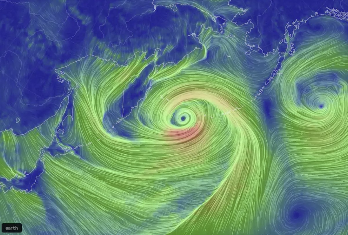
A powerhouse storm explosively intensifying in the northern Pacific could rank as the strongest nontropical cyclone observed in that ocean basin.
The storm’s pressure has already dropped to 928 millibars on New Year’s Eve, and is predicted to drop as low as 920 millibars, which would be even lower than extreme cyclones that formed in the same vicinity in 2014 and 2015.
The OPC 06z surface analysis below shows the #HurricaneForce low in the West Pacific has continued to intensify, dropping another 13 mb over the last 6 hours. The winds have likely reached maximum intensity at 95 kt, but the pressure is still forecast to drop even more. pic.twitter.com/1OgmIpwLDC
— NWS OPC (@NWSOPC) December 31, 2020
The lower the pressure, generally, the stronger the storm.
On Thursday morning, the National Weather Service’s Ocean Prediction Center confirmed that the storm is already generating 110 mph winds.
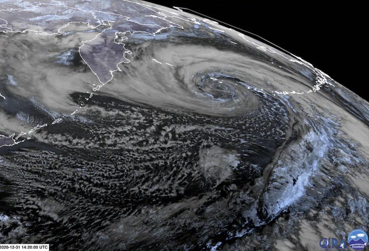
On satellite imagery, the storm appears as a giant comma shape swirl of clouds, a textbook appearance for a strong non-tropical weather system.
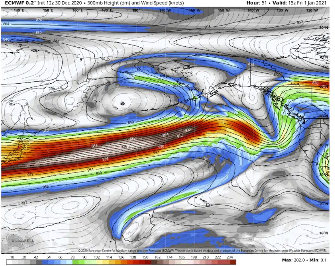
The European model predicts the storm’s pressure to bottom out at 919.9 millibars around 9 or 10 a.m. Eastern time Thursday. The two northern Pacific cyclones that set records in 2014 and 2015 saw their pressures level off at around 924 millibars.
At 7 a.m. Wednesday, the European model had analyzed the storm’s pressure at 972 millibars. It predicts the pressure will tumble to 921 millibars just 24 hours later, a 51-millibar drop. This plunge in pressure is double the criteria for “bombogenesis,” in which a storm’s pressure drops 24 millibars in 24 hours and earns the “bomb cyclone” moniker.
This 2020 Pacific bomb cyclone and its ultralow pressure represent an amazing contrast from an exceptional high-pressure zone over Mongolia, which may have set a world record on Tuesday.

At 7 a.m. local time on Tuesday, the mean sea-level pressure at Tsetsen-Uul, Mongolia, rose to 1,094.3 millibars, about 174 millibars higher than the projected pressure in the Pacific cyclone.
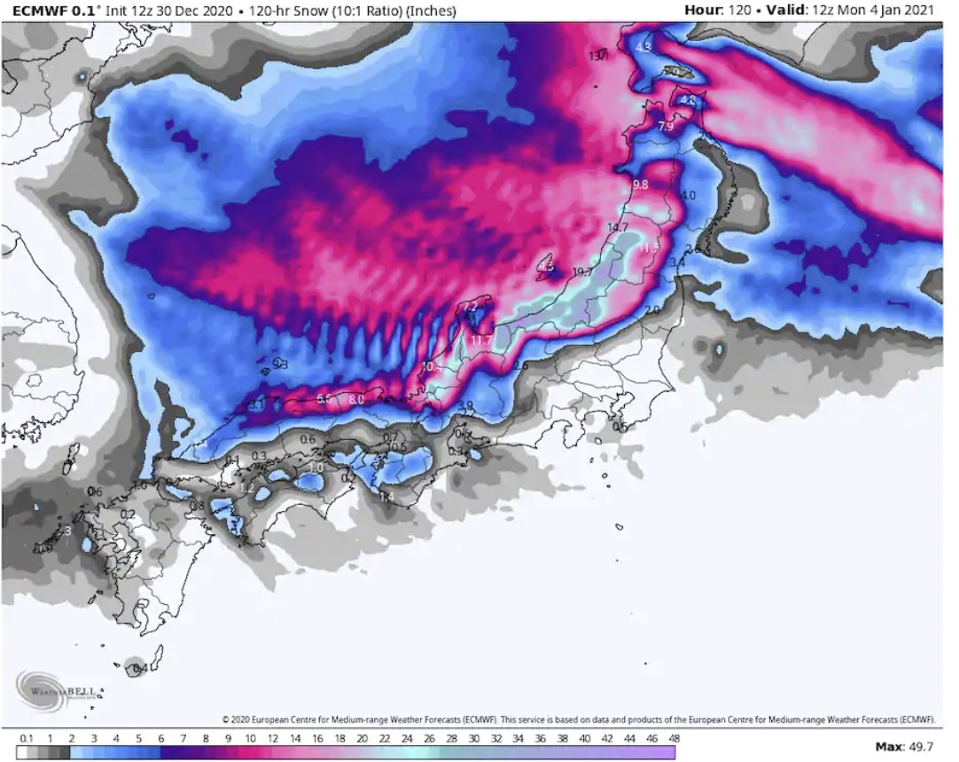
East Asia sits in the transition zone between these two extreme pressure centers, and the resulting northerly winds funneling over the Sea of Japan are predicted to cause a massive “sea effect” snowstorm for the Japanese Alps downwind.
Multiple feet of snow are forecast for the high terrain on Honshu through Saturday morning. This same region is just recovering from up to seven feet of snow earlier this month.
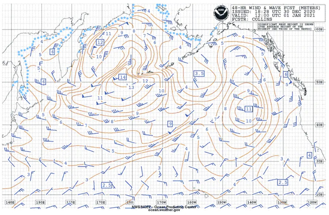
Meanwhile, the Pacific storm, in addition to unleashing winds topping 100 mph, is predicted to generate waves over 45 feet over the open waters.
Such storms generally go unnoticed except for meteorologists and those with maritime interests such as shipping, military and fishing. They are common in winter, although this particular storm is likely to reach the upper echelon of those ever observed in terms of its intensity.
While their pressures are extremely low, they do not fall as low hurricanes and typhoons, which have been known to drop below 900 millibars.
“Unlike hurricanes, these large and powerful storms go unnamed. And unlike hurricanes, they derive their energy from an entirely different process. While hurricanes extract heat from the ocean, maritime cyclones create energy by drawing together warm and cold air masses. When the warm air rises and cold air sinks, the kinetic energy of swirling wind is generated. The juxtaposition of warm and cold air is also what powers the polar jet stream — and indeed, maritime cyclones and the jet stream are inextricably linked — the one feeding back upon, and enhancing, the other.” explains severe-weather expert Jeff Halverson.
Indeed, the European model forecasts the jet stream transiting the Pacific to reach astonishing speeds of 230 mph (200 knots) at an altitude of 30,000 feet Thursday into Friday.
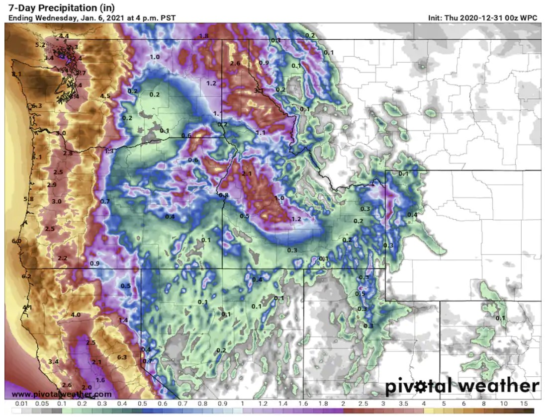
This rip-roaring jet stream is likely to carry weather disturbances into the Pacific Northwest and even California over the next week.
The National Weather Service is predicting four to eight inches of rain from the coast of Northern California into Washington state over the next seven days. In the high elevations, snowfall will be extreme, measured in feet.
With the jet stream bombarding the West Coast and drawing in Pacific air, the eastern United States is expected to be generally mild next week as the flow of Arctic air into the Lower 48 is cut off.
Yes, extreme weather never stops! Even on New Year! Be ready and get prepared! More extreme weather news on WP, Strange Sounds and Steve Quayle.


 in 3 days of storm")
We are doomed one way another… Ice Age, Global Warming both brings new diseases and kill 90 Percent of Humanity. Movie Stand is one of them.
Slant rhyme — with pun. ?
That was for Cathy.
Ahhahaha
https://www.infowars.com/posts/attorney-lin-wood-claims-jeffrey-epstein-still-alive/
IF TRUE, GAME OVER.
There goes the “globull warming” and drought baloney. All that snow will replenish the water table, people will go out and sled, ski, snowmobile. Happy New Year!
Off topic:
https://www.newstarget.com/2020-12-30-5500-page-covid-relief-bill-could-criminalize-sharing-memes-online.html
We don’t need anti-1st Ammendment garbage.
Supplmental:
https://www.usgs.gov/special-topic/water-science-school/science/snowmelt-runoff-and-water-cycle?qt-science_center_objects=0#qt-science_center_objects
I betcha the 200lb. – 400lb halibut will be active. Probably yank out some big toads after storm. I had fresh halibut from my Alaskan friends 24 hour shipped. So thick and juicy. Best halbut I ever ate.
And I guess you shared that with us just for the halibut. Couldn’t resist. ??