Although it’s the peak time of the year for strong storms in the North Atlantic…
What’s been especially noteworthy about the winter’s weather is the frequency and intensity of the storms spawned in the North Atlantic. Yes, it’s the third extraordinarily intense North Atlantic bomb cyclone in 10 days. And that’s unprecedented!
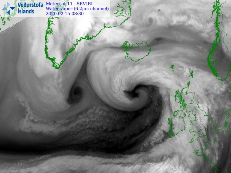
This is the peak time of year for bomb cyclones in the North Atlantic due to the insane power of the jet stream and intense air mass differences that tend to move over moisture-rich waters.
But, what’s been especially noteworthy about the winter’s weather is the frequency and intensity of the storms spawned in the North Atlantic.
Gulp!
— Britgirl Explains Brexit #FBPE (@MarieAnnUK) February 15, 2020
Earlier today at Heathrow Airport#StormDennis
pic.twitter.com/3FlmVtjO3k
Normally, just a few of extratropical cyclones see their minimum air pressure drop to 930 millibars or lower.
Yet assuming Storm Dennis does so, this will have happened three times in the past 10 days, just after the low-pressure area that helped propel Storm Ciara into Europe last weekend also bombed out.
Storm 10 , Lantic Bay #stormdennis pic.twitter.com/nL559whefu
— Will (@PolruanPilot) February 15, 2020
Energized by an unusually powerful jet stream — a highway of air at about 30,000 feet that is powered by the thermal contrasts between air masses — these weather systems are developing rapidly and reaching extraordinary intensities in a region already known for strong winter storms.
Winds in the core of the jet stream are forecast to be as strong as 240 mph late Friday, which could lead to another record for the fastest transatlantic flight, first broken Sunday.
? Waterfalls going upwards ?
— YorkshireShepherdess (@AmandaOwen8) February 15, 2020
*Apologies for muffled sound, conditions were dire, so much so that I have my big coat on*#StormDennis #weather #flood pic.twitter.com/WQSl18cd5q
The Arctic Oscillation
The Arctic Oscillation (AO) is a climate pattern characterized by winds circulating counterclockwise around the Arctic at around 55°N latitude.
When the AO is ‘positive’, a ring of strong winds circulating around the North Pole acts to confine colder air across polar regions.
In its negative phase, the AO is weaker and more distorted, allowing southward penetration of colder, arctic airmasses and increased storminess into the mid-latitudes.
We are currently in a positive state, with a very strong jet stream, low pressure predominating near Greenland and a ridge of high pressure to its south in the northeastern Atlantic.
That ‘positive’ Arctic Oscillation is one of the main reasons winter has been absent in much of the eastern United States and parts of Europe, and it’s helping to turn the North Atlantic into a virtual bomb cyclone express lane.
The wind and rain may steal the headlines as #StormDennis batters north-west Europe this weekend, but the temperature anomalies will be truly staggering.
— Scott From Scotland (@ScottDuncanWX) February 15, 2020
Overnight temperatures in the mid-high teens Celsius for Central Europe and reaching 25°C in southern France?
'Winter' pic.twitter.com/WKoZw9TGfl
In addition to the deaths and damage from Ciara, the winter’s North Atlantic storms have also affected North America.
Last month, for example, Newfoundland and Labrador were buried by one of their worst blizzards on record, when a storm underwent rapid intensification and piled snow up to the second and third stories of buildings in downtown St. John’s.
The next explosive cyclogenesis
The next bombogenesis has been named Storm Dennis, and computer models as well as meteorologists forecast its air pressure to plummet to between 916 millibars and 924 millibars. This range would qualify it among the top five strongest North Atlantic storms ever observed.
The strongest North Atlantic cyclone on record was the Braer Storm in 1993, which had a minimum central pressure of 913 millibars. That storm was named after an oil tanker that broke apart during the storms in the Shetland Islands, resulting in a large and damaging oil spill. Be prepared for Storm Dennis, It could reach the same level of insanity! More extreme weather news on Strange Sounds and Steve Quayle.


 in 3 days of storm")


