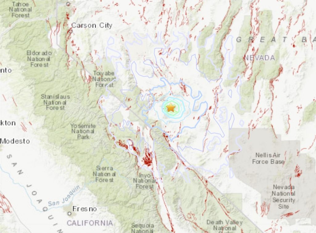
A very shallow M5.1 earthquake rattled Nevada on Dec. 1st, 11:32:56 p.m. UTC. The main tremor was directly followed by a swarm counting now more than 220 quakes and still increasing.
The quake hit at 3:32 p.m. local time at a depth of 3.1 miles (5km) about 15.5 miles south of Mina, Nevada.
As it turns out, the Monte Cristo Earthquake sequence in Nevada is a late bloomer. Another relatively large (M4.9) aftershock today. Again strike-slip, but this one is located away from the high density part of the aftershock zone, unlike the event one month ago. pic.twitter.com/gsWURfsKkg
— Jascha Polet (@CPPGeophysics) December 2, 2020
Weak shaking might have been felt in Benton (pop. 280; 33 miles away), Hawthorne (pop. 3,300; 39 miles away), Goldfield (pop. 270; 55 miles away), West Bishop (pop. 2,600, 60 miles away), Mammoth Lakes (pop. 7,900; 62 miles away), and June Lake (pop. 630; 62 miles away).
A swarm of aftershocks followed the quake, including two M4.3 (3:43 p.m. and 3:47 p.m.) and two M4.4 quakes (6:23 p.m. and 8:48 p.m.).
One of the trongest earthquake in Nevada history hits on May 15, 2020, when a M6.5 magnitude blast rattled 225 miles from Las Vegas.
Since the start of 2020 the USGS has recorded over 78,000 earthquakes in the contiguous United States.
Most of them were tiny; only 13 were larger than M5.
The largest two, both M6.5, were in Nevada and Idaho, widely felt, but for the most part away from population centers.
Since the start of 2020 the USGS has recorded over 78,000 earthquakes in the contiguous United States. Most of them were tiny; only 13 were larger than M5. The largest two, both M6.5, were in Nevada and Idaho, widely felt, but for the most part away from population centers. pic.twitter.com/oOmQpOpXp6
— USGS Earthquakes (@USGS_Quakes) November 27, 2020
More US earthquake news on USGS, Strange Sounds and Steve Quayle.
If you are already planning your Christmas gifts, please buy with us on Amazon. The affiliate sales will help us to continue the hard work we are putting in this website.


Our weatherman just posted about the Mina NV earthquake today. I immediately started looking up the DUMBS locations in NV. I think they might be blowing up tunnels as well.
Al nations have built under ground tunnels.
Thursday December 3 2020, 04:20:56 UTC 2km E of The Geysers, CA 0.7 1.1 USGS Feed Detail
Thursday December 3 2020, 04:18:16 UTC 24 km S of Mina, Nevada 0.9 0.1 USGS Feed Detail
Thursday December 3 2020, 04:16:10 UTC 5 km SSW of Volcano, Hawaii 2.1 1.3 USGS Feed Detail
Thursday December 3 2020, 04:13:05 UTC 5 km SW of Volcano, Hawaii 1.9 -0.2 USGS Feed Detail
Thursday December 3 2020, 04:10:54 UTC 6 km SW of Volcano, Hawaii 1.8 0.5 USGS Feed Detail
Thursday December 3 2020, 04:09:39 UTC 5 km SW of Volcano, Hawaii 2.0 0.8 USGS Feed Detail
Thursday December 3 2020, 04:08:43 UTC 24 km SSE of Mina, Nevada 1.5 6.8 USGS Feed Detail
Thursday December 3 2020, 04:01:39 UTC 7km WNW of Lake Henshaw, CA 1.2 13.5 USGS Feed Detail
Thursday December 3 2020, 04:00:44 UTC 32 km SE of Mina, Nevada 1.3 7.0 USGS Feed Detail
Thursday December 3 2020, 03:59:20 UTC 7 km SW of Volcano, Hawaii 3.1 1.8 USGS Feed Detail
Thursday December 3 2020, 03:56:15 UTC Island of Hawaii, Hawaii 1.7 1.2 USGS Feed Detail
Thursday December 3 2020, 03:54:50 UTC 5 km SSW of Volcano, Hawaii 1.9 0.5 USGS Feed Detail
Thursday December 3 2020, 03:53:52 UTC 5 km SW of Volcano, Hawaii 1.8 1.3 USGS Feed Detail
Thursday December 3 2020, 03:50:59 UTC 25 km NW of Langsa, Indonesia 4.8 10.0 USGS Feed Detail
Thursday December 3 2020, 03:49:50 UTC 8km SSW of Idyllwild, CA 0.9 16.7 USGS Feed Detail
Thursday December 3 2020, 03:47:29 UTC 8km NE of Coso Junction, CA 1.2 3.0 USGS Feed Detail
Thursday December 3 2020, 03:43:46 UTC 33 km SE of Mina, Nevada 1.9 6.7 USGS Feed Detail
Thursday December 3 2020, 03:38:59 UTC 7km SSW of Pearblossom, CA 1.5 9.8 USGS Feed Detail
Thursday December 3 2020, 03:37:58 UTC 33 km SE of Mina, Nevada 1.7 5.8 USGS Feed Detail
Thursday December 3 2020, 03:36:38 UTC 23 km SSE of Mina, Nevada 1.3 0.4 USGS Feed Detail
Thursday December 3 2020, 03:35:23 UTC 9 km SSE of Volcano, Hawaii 0.8 2.4 USGS Feed Detail
Thursday December 3 2020, 03:32:48 UTC 32 km SE of Mina, Nevada 2.3 6.3 USGS Feed Detail
Thursday December 3 2020, 03:31:23 UTC 24 km S of Mina, Nevada 2.0 5.6 USGS Feed Detail
Thursday December 3 2020, 03:30:35 UTC 25 km S of Mina, Nevada 2.3 3.2 USGS Feed Detail
Thursday December 3 2020, 03:29:39 UTC 25 km S of Mina, Nevada 1.8 1.7 USGS Feed Detail
Thursday December 3 2020, 03:27:19 UTC 8 km SSE of Volcano, Hawaii 0.6 1.9 USGS Feed Detail
Thursday December 3 2020, 03:19:42 UTC 34 km SE of Mina, Nevada 2.9 8.2 USGS Feed
Wonder if one of those slave trafficking tunnels was destroyed. Supposed to be underground network of tunnels where all kinds of illegal activities go on right under our cities.
Maybe a D.U.M.B base caved in?