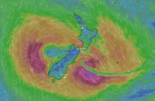
New Zealand has been ravaged by former Cyclone Gita, which brought 15m waves, more than 300mm of rain, and wind gusts above 130km/h – and it is not over yet. The system has split in two – caught up by the Southern Alps – and the main low is now hovering near Banks Peninsula and another is to the west. The mountains held up the lower parts of the system as it moved across the country, while the upper parts moved past. Christchurch, Buller District, Grey District, Selwyn, Westland, Tasman and Taranaki declared a state of emergency yesterday as the powerful storm arrived through the day, causing flooding, destroying buildings and closing roads.
The heaviest rain fell in Canterbury, where over 300mm was recorded at a station in the Kaikoura ranges, and 200mm at Carrington Hut in Arthurs Pass National Park.
Many other areas recorded more than 150mm, and even coastal parts had a lot of rain, including 64mm in Christchurch, 94mm in Ashburton, and more than 100mm in Timaru.
Taranaki experienced “exceptionally strong” winds. A gust of 130km/h was recorded at 7pm. Whanganui recorded winds of 109km/h, Kelburn in Wellington 118km/h and the top of Rimutaka Hill 131km/h. On the West Coast of the South Island savage easterly winds ripped roofs off houses, reaching 118km/h in Westport and 124km/h at Cape Foulwind.
The largest waves were recorded by the Port of Taranaki, with a 8.3m northwest swell and a maximum wave height of 15m. It is an unusual swell direction too. It is very uncommon to get an 8m northwest swell, and even a 4m swell from there. It is a very rare event.
More than 100 tourists were trapped overnight in Whataroa, south of Greymouth, and thousands of people lost power around the country.
The good news is a southerly airflow will come through over Thursday and Friday, bringing an end to some of the oppressive humidity.
But with those sorts of impacts I would be surprised if there is no damage this morning.
Two days ago, the polar vortex also split in two, having critical weather consequences for Europe, America and Greenland.


[…] as former Cyclone Gita hit New Zealand with heavy rains, extreme winds, and huge waves, a unexpected phenomenon was caught around the Rakaia Gorge by Joe Todhunter and Donna Field. These […]