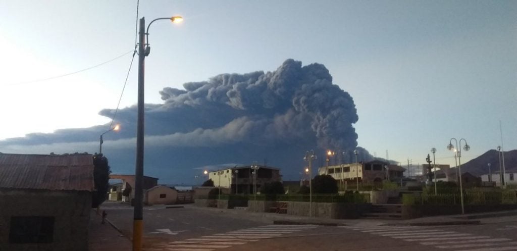
Hundreds of people living near the Ubinas volcano have been evacuated after the volcanic peak erupted 07:35 UTC (02:35 local time) on July 19, 2019.
The ash plume reached an altitude of 40,000 ft (12km). The alert level has been raised from yellow to orange.

The National Institute of Civil Defense (Indeci) ordered the evacuation after the Ubinas volcano, the most active in the country located in the Moquegua region, recorded two explosions that led to ash being spewed within a radius of 25 km (16 miles), affecting at least eight inhabited areas.
La naturaleza a veces nos vuelve a mostrar cuán grande es. #Ubinas pic.twitter.com/xxpsgXZFWW
— AnaLucia Vizcardo (@analucia_vm) July 19, 2019
Ashfall was reported in the towns of Ubinas, Escacha, Anascapa, Matalaque, San Miguel, Huarina and Tonohaya.
Desde las 2:30 a.m. de hoy, el #IGP viene alertando de la situación a las autoridades regionales a fin de que tomen acciones preventivas a favor de la población. (2/2) pic.twitter.com/BiHQ7QzKOz
— Instituto Geofísico del Perú (@igp_peru) July 19, 2019
“Actions are being taken for around 1,000 people living in the areas around the Ubinas volcano, so they can be relocated to shelters already provided for in contingency plans,” Indeci chief Jorge Chavez told local radio station RPP.
#UBINAS: imágenes de la actividad del volcán ?: la primera muestra el registro sísmico y la actividad de tipo tremor que estaría vinculada a la emisión continua de cenizas; la segunda, la expulsión de ceniza y proyectiles balísticos como resultado de las violentas explosiones. pic.twitter.com/QYSuayUWJV
— Instituto Geofísico del Perú (@igp_peru) July 19, 2019
The education ministry said that in towns near the volcano, about 1,200 km (745 miles) south of Lima, classes were suspended and people were given masks and goggles as protection against the ash and gases from the volcano.
The Geophysical Institute of Peru (IGP) said that the explosions had started since dawn on Friday.
Southern Peru, an area where there are important mining sites, is home to a dozen active volcanoes.
[AHORA] Señales sísmicas que estaban siendo correlacionadas con emisiones de ceniza están regresando a niveles observados antes de las explosiones. Ello también queda graficado en la disminución de la altura de las explosiones, las cuales alcanzan los 1500 sobre el cráter. pic.twitter.com/uO7ST9EtnM
— Instituto Geofísico del Perú (@igp_peru) July 19, 2019
Peru is also in the so-called Pacific “Ring of Fire,” an area with a high incidence of earthquakes and volcanic activity.
[Gestion, Volcano DIscovery, Yahoo, MSN]


