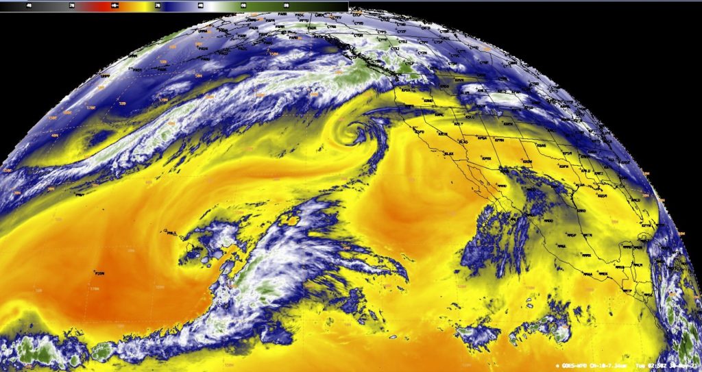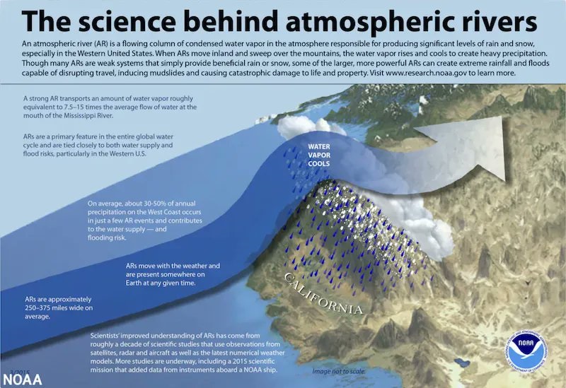
Another atmospheric river is about to slam into western Washington and parts of British Columbia, Canada, for the third time in just under a week on Tuesday-Wednesday.
Here comes the third atmospheric river in just under a week that will once again give rain heavy at times over the BC south coast. Heavy rain may ease somewhat Tuesday night but will persist through Wednesday as a cold front moves across the region. #Goes17 #BCStorm pic.twitter.com/x6ryC0WQrX
— Jason Ross (@Squamishweather) November 30, 2021
While back-to-back-to-back systems for the region seem a bit like a broken record lately, the phenomenon is truly significant.
Rivers in the sky have led to landslides blocking roads, rivers inundating towns, and in one case, returning an old lake bed back into a lake.
CW3E AR Update: The third #AtmosphericRiver in a sequence of ARs will make landfall across British Columbia and Washington later today. pic.twitter.com/buEzz1BHJp
— CW3E Scripps (@CW3E_Scripps) November 29, 2021
The new monster storm is about 8,000km long
Astounding view from space of a several thousand mile-long atmospheric river being pushed across the North Pacific into British Columbia by an exceptionally strong Pacific jet extension. #BCstorm #BCflood pic.twitter.com/lRSItbdwk0
— US StormWatch (@US_Stormwatch) November 30, 2021
British Columbia
British Columbia typically sees atmospheric river events in the month of November, just as the Pacific Northwest does. The problem for both regions this year has been the consistency of the systems, with no breaks for drying in between.

“The first atmospheric river event hit us hard on November 13 to 16, and it dumped a lot, 150-300 mm (roughly 6 to 11 inches), of precipitation in less than 48 hours,” Johnson Zhong, a meteorologist for Environment Canada said.
Updated November monthly averages and rainfall totals so far this month across #BC cities, majorly from the multiple rounds of #AtmosphericRiver events. More to come, 100-200+ through Wednesday for Tofino and Hope, who have already seen over 600mm #BCStorm #BCFlood #BCwx pic.twitter.com/TnjIUQtXMz
— Rachel Modestino TWN (@ThatMetGirl) November 29, 2021
There has also been rain on top of fresh snow, which has exacerbated flooding.
“There was up to 30-50 cm (1-1.5 feet) of fresh snow at 1500-2500 meters (5,000-8,000 feet) high,” he observed. “One of our atmospheric river events rained much higher than 2500 meters, so that rain melted the snow and helped create the flooding.”
New Lake in Suma
One of the areas seeing the greatest amount of flooding was the Sumas area, about 50 miles east of Vancouver.
“One hundred years ago there was a Sumas lake. Then they pumped the water out to make good farmland. It has been farmland for the last 100 years, and now it’s a lake again,” Zhong explained.
What is Sumas Lake? 100 years ago, Abbotsford had a 134 sq km lake. So why are we say climate change caused this flooding in BC? Do not build in a lake bed. https://t.co/3TqkM84KvX
— Rob (@RobYEG) November 28, 2021
The unprecedented amount of rain has created major flooding, washing out bridges and roads, completely cutting off many other small Canadian towns to the rest of the world.
Merritt, British Columbia, is one of those towns.
“Merritt is a town of 7,000 people and is totally flooded,” Zhong said. “That town is in an area that doesn’t get a lot of rain. But with the combination of rain and snowmelt, the entire town flooded. The water and sewage system went down, and the entire town had to be evacuated.”
Third atmospheric river in a row
Now the thrid wave is coming. Environment Canada says up to 200 millimeters of rain could drench the central coast of B.C. and parts of Vancouver Island through Wednesday, possibly causing water to pool on roads and flooding in low-lying areas.
Another potent Category 4 atmospheric river tapping into tropical moisture is headed for waterlogged British Columbia and the Pacific Northwest and is expected to bring additional heavy rainfall and flooding. #WAwx #BCstorm #BCflood pic.twitter.com/qYf9eijtUa
— US StormWatch (@US_Stormwatch) November 30, 2021
The third so-called atmospheric river comes after Environment Canada issued a red-level alert due to heavy rainfall that was expected to intensify today and ease on Wednesday.
That’s when a cold front is expected to move across Metro Vancouver to Whistler, with a forecast calling for strong southeasterly winds with gusts up to 60 kilometres an hour accompanying the storm.
Updated November monthly averages and rainfall totals so far this month across #BC cities, majorly from the multiple rounds of #AtmosphericRiver events. More to come, 100-200+ through Wednesday for Tofino and Hope, who have already seen over 600mm #BCStorm #BCFlood #BCwx pic.twitter.com/TnjIUQtXMz
— Rachel Modestino TWN (@ThatMetGirl) November 29, 2021
British Columbia has suffered a great deal since the summer months. They endured a relentless heatwave that gripped the entire region and killed nearly 600 people.
They also experienced wildfires that completely wiped the town of Lytton off the map. Fresh burn scars from the wildfires are also making the flooding and mudslide potential worse, Zhong pointed out.
Washington
Mudslides and landslides are a major concern for both British Columbia and Washington.
“Persistent rainfall over the last few weeks has dramatically increased soil moisture to high levels across western Washington,” the National Weather Service (NWS) office in Seattle reported. “Heavy rainfall of an additional 1 to 3 inches in the mountains and up to 1.5 inches in the lowlands has fallen over the last 24 hours. Therefore, the increased threat of landslides will continue through today despite the heaviest rainfall coming to an end.”
In the Seattle area, which is soaked as well, they hope all the rain doesn’t come at once.
Seattle is experiencing its wettest fall on record. The Seattle-Tacoma airport has recorded 18.91 inches of rain for September through November, and more is on the way.
Somebody else pointed this out today–it does look like Seatac has had the wettest fall (well, Sept thru Nov) on record. Here’s the top ten: pic.twitter.com/rzReLWRTDE
— NWS Seattle (@NWSSeattle) November 29, 2021
By Tuesday, the month could end as one of the top wettest Novembers on record. With an additional 2 to 3 inches of rain expected to fall, more flooding is inevitable.
“The big factor that will affect the scope of expected impacts will be how much of a break we receive in areas where river flooding continues today,” the NWS in Seattle emphasized.
The Nooksack and Skagit Rivers, north of Seattle, are still rising and have yet to crest, so more rainfall on top of already rising rivers could create major flooding issues for nearby towns.
“It remains unclear how rivers in these areas will respond to additional rainfall over the next 2 days,” NWS Seattle added.
Snow and already flooded
The next atmospheric river event is expected to arrive in the Pacific Northwest and British Columbia early this week, bringing even more flooding rain to the region.
Warmer atmospheric temperatures, in general, will mean the freezing levels are higher than they’ve been in the past. But while storms vary just by natural situation, it’s clear the background warming should increase the freezing levels.
Take note if you’re heading into the backcountry on #VancouverIsland or mainland. Recent snow followed by tomorrow’s “atmospheric river” is creating dangerous avalanche conditions. @CHEK_News @avalancheca #avalanche #hiking #skiing pic.twitter.com/xx7ApGsa6k
— Dean Stoltz (@deanstoltzchek) November 30, 2021
A higher freezing level, the altitude at which rain transitions to snow, can be dangerous with a wet landscape and full rivers.
“This makes for extra potential potency to the impact,” he said. “The rivers are already high again, so this one’s going to pack a wallop.”
Warmer air can also hold more water vapor, which fuels atmospheric rivers. As the atmosphere gets warmer, the intensity of storms will likely increase and become more hazardous.
“As a scientist, my role is to help raise awareness that the situation is looking to be like a strong to extreme [atmospheric river], and the implications of that are for additional heavy rain and — given the situation on land — flooding,” he said. “People should really look to their normal weather information provider for hazardous situations for specific guidance on what to do, because it seems to me that this is a pretty serious situation.”
All hands on deck to prepare to move farm animals during another atmospheric river that BC doesn’t need. @JohnShrable @MabrisaWX @RobMayeda @tessvanstraaten @AnthonyFarnell https://t.co/IEuNPX9HLu
— Julianna Griffin (@JulesGarden63) November 30, 2021
Lake effect snow
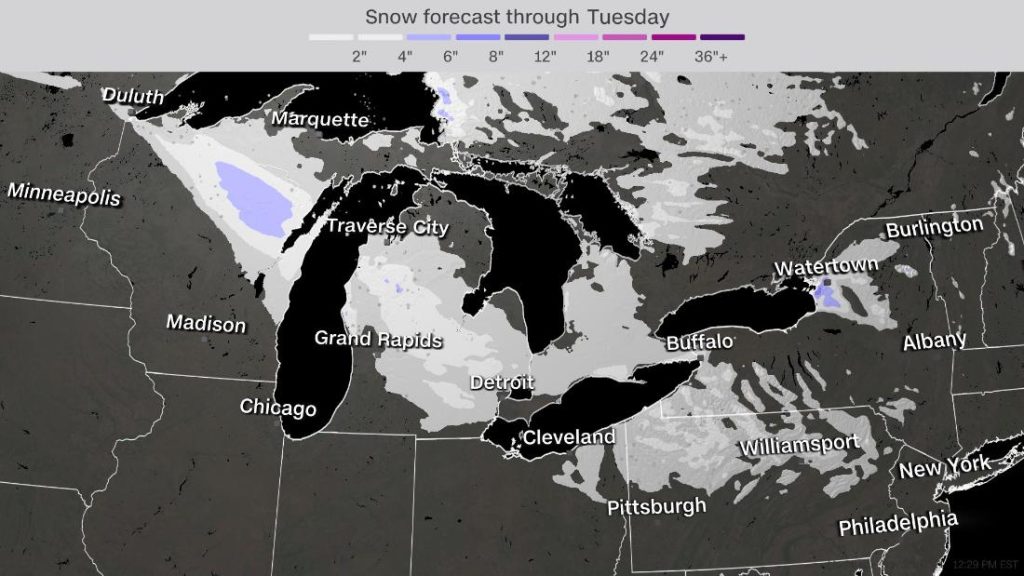
Another lake-effect snow event will impact portions of the Great Lakes this week.
“Snowfall totals will be less than the previous system, but areas downwind of the Great Lakes may receive higher amounts due to lake effect enhancement,” the Weather Prediction Center said.
Most of the areas receiving snow won’t see very high totals. Most of the snow this week will stay under three inches.

However, in parts of Michigan, it could create a few problems for travel. The NWS office in Grand Rapids has issued a winter weather advisory, with heavy snow expected during the evening commute. Up to three inches of snow could fall in less than four hours.
“Impacts to roads may be small at first given temperatures initially above freezing, but we should start to see some slick roads developing after dark,” stated the NWS office in Grand Rapids. The snow should wrap up by Tuesday, with drier conditions to follow for the next several days.
California fire threat remains
When high pressure is located east of the mountains, winds are able to funnel through the valleys, increasing in speed, creating dangerous fire conditions for California.
When high pressure is located east of the mountains, winds are able to funnel through the valleys, increasing in speed, creating dangerous fire conditions for California.
Heatmap for new CHP-reported California fires: 2021-11-28 pic.twitter.com/gh0ni3doqX
— Cal Fire Bot (@CalFireBot) November 29, 2021
An elevated fire threat remains for much of southern California through most of the week.
Winds around the Los Angeles area will gust up to 45 mph at times and humidity levels are between 5-15%. The dry, warm conditions will enhance fire risk through the week.
“Fast fire growth is possible if a fire starts. Use extreme caution with potential fire ignition sources and be prepared to evacuate quickly if a wildfire develops nearby,” urged the NWS office in Los Angeles.
Santa Ana winds will return to Southern California later this week with wind gusts up to 50 mph: https://t.co/qGQqzNEKoS pic.twitter.com/nO22K6LH0j
— Breaking Weather by AccuWeather (@breakingweather) November 29, 2021
The Santa Ana wind event from last week brought winds near 90 mph for some locations and caused power outages for more than 70,000 homes and businesses. While the wind threat this week isn’t nearly is intense as last week, the fire threat still remains and fires could easily ignite. [Energic City, CNN]
Now subscribe to this blog to get more amazing news curated just for you right in your inbox on a daily basis (here an example of our new newsletter).
You can also follow us on Facebook and/ or Twitter. And, by the way you can also make a donation through Paypal. Thank you!
You should really subscribe to QFiles. You will get very interesting information about strange events around the world.


Well, the Pacific Northwest is wetting up. That’s good. Enjoy the snow, let the ground soak up the fresh rain. Fold up any drought propaganda scripts. Merry Christmas.
Thanks Susan i am agree with you as well…. We all are in it together. Every time invisible enemy changes clothing and they panic , wall street crashed 642 points. So my predictions was
one day short… High accuracy.. We tell news before it happens not happens after? This is most intel sites that all the world look at.. This is very big place… Indeed.. Susan check this web site as well. https://endoftheamericandream.com/why-is-so-much-seismic-activity-suddenly-rocking-our-planet/
Mohamed, agree with you. WWIII has started, it’s just the world hasn’t woken up to that fact yet. Check this out everyone – the real reason for the “vaccines”: https://leohohmann.com/2021/10/26/why-fauci-and-the-global-cabal-insist-your-children-be-injected-for-protection-against-a-disease-that-poses-no-threat-to-their-health/#more-8053
Well maybe Chaz will have to fold up their riot and destruction business, could it be judgment from on high??
5-year-old student shoots dead three kids at Michigan high school and wounds two others and a teacher: Male shooter is arrested and revolver is recovered
Police responded at around 12:55pm to a report of an active shooter at Oxford High School in Oxford Township, a suburb north of Detroit
Police said that between four and six students were injured, and the gunman has been arrested
Senator Rosemary Bayer called the incident ‘horrifying’ in a statement
A handgun has been recovered dailymail news endofamericandream duck duck go it
We are under attack by Queen of London, HAARP and gang of Globalists. They want us to take vaccines or ruin all world.
Oxford mass shootings in Detroit is head lines fox news..
Iran will go to dark winter soon zero hours is starting now. Israel
has over 300 F16 -35 will attack Iran without contact soon…World war 3 is ready to blown up sooner than later Putin will take over Ukraine. China will take over Taiwan, Iran will go nuclear melt down soon? Mass looting will result in Martial Law
in Chicago and rest of nation.
“Judgement”?