Severe weather will threaten over 30 million on Saturday from Florida to New York, with everything from hail and isolated tornadoes to torrential downpours and damaging wind gusts possible.
After driving tornadoes through parts of the Tennessee and Ohio valleys, as well as the South on Friday, a potent storm is forecast to trigger severe weather in the eastern United States as well.
“Saturday will likely be an active day weather-wise, as we will be monitoring the threat of thunderstorms throughout the afternoon,” said AccuWeather Meteorologist Brandon Buckingham.
There will be two areas of potentially severe weather across the East, with coastal cities like Savannah, Georgia, Myrtle Beach and Charleston, South Carolina, and Wilmington, North Carolina, among those in the southern portion of severe.
PROTECT YOUR HOME AND CAR WITH THE BEST LIGHTNING AND EMP PROTECTION AVAILABLE…
This Southeast section is forecast to have only locally severe storms, though any thunderstorm that blows through could produce a brief downpour and cause travel disruptions, and the other is the risk of an isolated tornado or two from Florida to southern Maryland and Delaware.
The heftier severe risk will be located farther north, where AccuWeather forecasters are keeping a sharp eye on some of the most populated cities in the U.S., including New York City and Philadelphia.
“With sufficiently mild and humid air in place combined with severe-worthy dynamics high in the atmosphere, AccuWeather meteorologists do expect thunderstorms to turn severe,” added Buckingham.
Hail, isolated tornadoes, damaging wind gusts and torrential downpours producing reduced visibility are anticipated with an AccuWeather Local StormMax™ of 75 mph.
PROTECT YOUR HOME AND CAR WITH THE BEST LIGHTNING AND EMP PROTECTION AVAILABLE…
Those traveling along major interstates like 76, 80, 81, 90 and 95 should prepare for delays from sudden bursts of severe weather. Motorists are recommended not to travel through flooded roadways and slow down and pull over if severe weather hits.
“We expect thunderstorm initiation to occur between 2 and 4 p.m. in central Pennsylvania and into upstate New York,” said Buckingham.
Those from State College, Pennsylvania, to Syracuse, New York, can expect the thunderstorms to arrive in the afternoon, with areas farther east waiting a bit longer for their severe weather.
“Storms should continue to advance eastward into the early evening hours, bringing along a threat for gusty winds, hail and even an isolated tornado into places like Binghamton, New York, Scranton and Allentown, Pennsylvania, and perhaps farther south and east into Philadelphia and New Jersey,” Buckingham said.
This severe weather will arrive accompanied by a larger storm that has been producing snow in the Plains and Great Lakes, as well as severe weather across the Ohio Valley and South.
“The threat will stem from an area of low pressure and its associated cold front that will march eastward through the Ohio Valley and Northeast into the evening hours Saturday night,” explained Buckingham.
After the severe storms move out Saturday night, Sunday is looking to be generally cooler and breezy. After temperatures rose into the 70s in most places across the Northeast on Friday, forecast highs in the 40s and 50s might bring a shiver despite being around average.
While there can be some showers mixing with snow in the interior Northeast, elsewhere across the Atlantic Coast is expected to be much drier as eyes turn to the next huge storm bringing potentially devastating severe weather to the South early in the traditional workweek.
Tornadoes across Tennessee and Ohio valleys on Friday
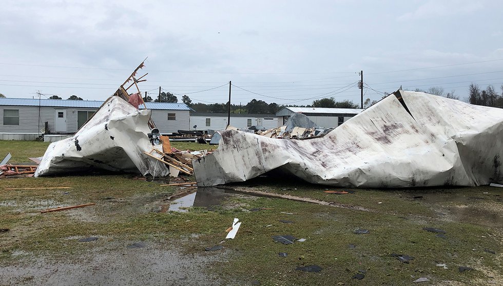
At least two people were hospitalized on Friday after a likely tornado tracked across southern Alabama as severe thunderstorms swept across the southeastern U.S.
Nine mobile homes were destroyed in Atmore, Alabama, when the tornado-warned thunderstorm moved through the area, according to WALA-TV. The National Weather Service has yet to determine if it was straight-line winds or a tornado that caused the damage.
PROTECT YOUR HOME AND CAR WITH THE BEST LIGHTNING AND EMP PROTECTION AVAILABLE…
Several people were injured in addition to the two people that were taken to the hospital by ambulance. Fortunately, no fatalities were reported and everyone that lives in the area has been accounted for, The Associated Press said.
“We had one guy that was in his mobile home when the storm hit. He was asleep. He said when he woke up, he was in the woods,” Escambia County Sheriff Heath Jackson said.
Video from Atmore showed mobile homes that were shredded apart during the intense storm with debris scattered across a large area.
“It’s devastating, and those people have nothing left. We are so thankful that nobody was killed or severely injured,” Jackson said.
PROTECT YOUR HOME AND CAR WITH THE BEST LIGHTNING AND EMP PROTECTION AVAILABLE…
The storm that hit Atmore was just one of many to rumble across the southeastern U.S. on Friday with the worst of the storms focusing on southern Alabama, southwestern Georgia and the Florida Panhandle.
Ominous shelf clouds appeared ahead of the storms as they approached, a type of cloud that is often associated with the leading edge of strong thunderstorms.
SEVERE WEATHER: A suspected tornado touched down in southern Alabama near the Florida panhandle, overturning several mobile homes and injuring six people. Now, that storm system is moving East. pic.twitter.com/4CSdjfKxM7
— CBS Evening News (@CBSEveningNews) March 18, 2022
Several other suspected tornadoes moved across places like Panama City, Florida, Elizabethtown, Kentucky, and Salem, Indiana. The tornado in Panama City reportedly blew a 24-foot boat off a trailer, damaged multiple homes and boat docks, and downed power lines. As of late Friday night, nearly 10,000 were without power across Jefferson County, Kentucky.
Residents across the Southeast should not let their guard down as a significant severe weather outbreak is in the forecast for a large area of the southern U.S. on Monday and Tuesday. [Accuweather1, Accuweather 2]
I just can emphasize enough! Protect your homes and families against these extreme weather outbreaks… Because it seems they are increasing in numbers and intensity!
StrangeSounds.org has been banned from ADS NETWORKS! CLICK HERE TO DONATE AND SUPPORT ME, MY WORK AND MY WEBSITE!
NOW PREPARE FOR THE NEXT NATURAL DISASTER AND EMERGENCY:
PROTECT YOUR HOME AND CAR WITH THE BEST LIGHTNING AND EMP PROTECTION AVAILABLE…
DRINK CLEAN WATER USING THE BEST HOME WATER FILTER AROUND…
You should really subscribe to QFiles. You will get very interesting information about strange events around the world.


 in 3 days of storm")


It will be at the Mercy of God … it is preferable that the US be destroyed by the elements of nature controlled by God than that it reach 10 thousand degrees Celsius as a result of Russia’s nuclear bombs and see the horror of the people who survive it .. .as the meat falls off the bones even alive
Probably be some big waterspouts near Florida. We are getting gusty and just below freezing at night. 60% snow tonight, near four courners area. I got my cedar logs burning. My dogs sleep on each side of me, and it helps at night. This Winter has been very normal out here.