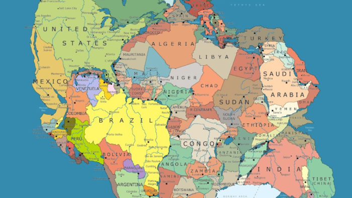
Take Pangea, the supercontinent that formed roughly 300 million years ago, and add the current geopolitical borders.
And now, where would you live on Pangea?
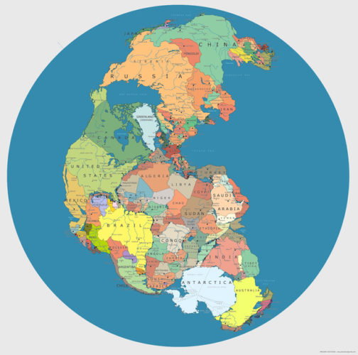
This totally anachronistic map – a modern map with its various parts relocated to the general position they would have occupied before Pangea began rifting apart some 200-million years ago is a mind-bending way of relating to the world on a geological time scale.
So How Long Did Pangea Break Up?
The breaking up and formation of supercontinents appears to have happened several times over Earth’s history with Pangea being one among many.
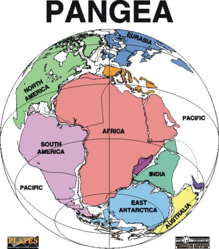
This supercontinent existed 250 million years ago during the Paleozoic and Mesozoic eras. During the ensuing millenia, plate tectonics slowly moved each continent to its current position on the planet. Each continent is still slowly moving across the face of our world.
Evidences speaking for this land mass lie in the fossil records from the period. It includes the presence of similar and identical species on continents that are now great distances apart.
Additional evidence for Pangaea is found in the geology of adjacent continents, including matching geological trends between the eastern coast of South America and western Africa. The polar ice cap of the Carboniferous Period covered the southern end of Pangaea. Glacial deposits of the same age and structure are found on many separate continents which would have been together in the continent of Pangaea.
Here a video showing one of the hypothesis behind the formation of the Early Earth and its evolution to the now-a-day Earth by plate tectonics:
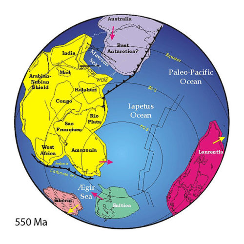
Pannotia Formation Prior Pangea
The next-to-last one, Pannotia, formed about 600 million years ago during the Proterozoic eon.
Pannotia included large amounts of land near the poles and only a relatively small strip near the equator connecting the polar masses.
60 million years after its formation, Pannotia broke up, giving rise to the continents of Laurentia, Baltica, and Gondwana.
Laurentia would eventually become a large portion of North America, the microcontinent of Avalonia (a small portion of Gondwana) would become the northeastern United States, Nova Scotia, and England. All of these came together at the end of the Ordovician. While this was happening, Gondwana drifted slowly towards the South Pole. These were the early steps in the formation of Pangea.
This absolutely amazing video traces the movement of the continents through the end of Rodinia to the formation of Pangea, and then on another 250 million years into our future:
The next step was the collision of Gondwana with the other land mass. Southern Europe broke free of Gondwana. By late Silurian time, North and South China rifted away from Gondwana and started to head northward across the shrinking Proto-Tethys Ocean. Movement continued slowly until the land masses drifted until their current positions.
From Pangea, to now … and don’t forget we are in constant move. How will our continents look like in the next geological Era? Geology is just awesome. This is also why I studied it.


 HOLE into earth’s crust")


Earth as a celestial body was formed as a result of the division of a large planet, which was several light years from the Sun Earth now observed from the planet and was drawn into the current Solar system by the forces of gravity of the planets already existing in this system. Under the influence of a number of internal and external factors, the planet core broke.
Two of the resulting fragments (the current planet Earth and its future moon satellite) remained in place, the rest scattered across interplanetary space. The moon’s location as a satellite of the Earth was later determined under the influence of gravitational forces, initially its orbit was different – the moon revolved around the sun.
This is the world after the 6th seal!
[…] Photo retrieved from: http://strangesounds.org/2013/06/where-did-you-live-on-pangea-amazing-contemporary-geopolitical-pang… […]
[…] fuente: http://strangesounds.org/2013/06/where-did-you-live-on-pangea-amazing-contemporary-geopolitical-pang… […]
[…] The new subduction crack has been found in the Eurasian plate that contains all of Europe and most of Asia. The new underwater crack was found near the site of the devastating Lisbon earthquake in 1755. As reported by the scientists, it could cause Earth’s continents to ‘look very much like the Pangea‘. […]
[…] Hérna sést Pangea eins og hún var, hvar löndin sem við þekkjum í dag voru stödd. Heimild. […]