Small tsunami waves were observed in Vanuatu and New Caledonia on Wednesday, December 5, 2018, following a magnitude 7.5 earthquake that occurred east of the Loyalty Islands in the South Pacific, according to the Pacific Tsunami Warning Center in Hawaii.

Waves reaching 72 centimeters in height were observed in Lenakel, Vanuatu, while waves almost half-a-meter-high were seen in Ouinne on the southeast coast of New Caledonia, the center reported.
Coastal areas along the east coast of the New Caledonia’s main island, as well the Isle of Pines and Loyalty Islands, both part of France’s New Caledonia territory, were evacuated, according to New Caledonian local media.
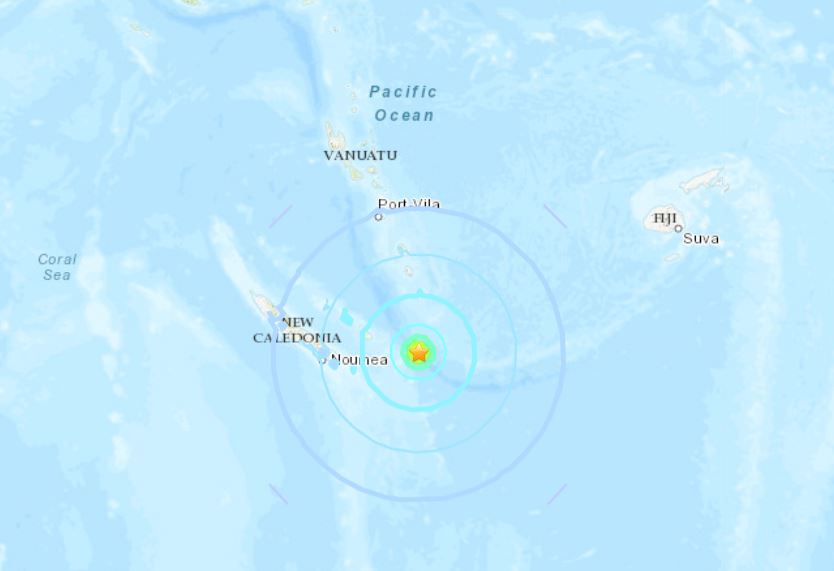
The undersea quake struck 168 kilometers east-southeast of Tadine in the Loyalty Islands at a shallow depth of 10 km at 3:18 p.m. local time, according to the U.S. Geological Survey.
Four minutes earlier, a magnitude 6 temblor was registered 155 km east-southeast of Tadine, also at a depth of 10 km.
Following the two quakes, the USGS recorded high levels of seismic activity in the area, with 10 more temblors occurring throughout the day, including one with a magnitude of 6.6 that struck at 5:43 p.m., 192 km east-southeast of Tadine also at a depth of 10 km.
Aftershocks are still undergoing.
The Pacific Tsunami Warning Center advised that hazardous tsunami waves up to 3 meter high could still reach some coasts of New Caledonia and Vanuatu. Waves up to 1 m are also possible for some coasts of Fiji to the east, it said.
Follow us on Facebook and Twitter or become a Patron on Patreon / donate through Paypal. Please and thank you
[Pacific tsunami warning center, Kyodo News, USGS 1, USGS 2]


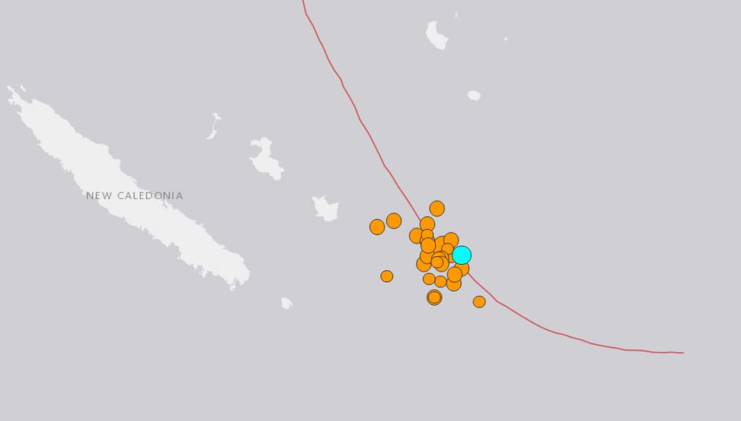
There were 33 “quakes” there on 5 December, 2018, almost all at focus depth 10.0 kms. But the CIA quake map logged none of them. That is stats and geologically impossible, never so many seen in one region on one day n six years of daily observation of all global qakes .
These are seabed bombs, dropped in this case by the French military, usually by USA and NATO, and as the Indons are doing around Lombok and Sulawesi, to attack theSE Asia HQ of ISIS on those islands. Done to trash the marine life, wreck boats in harbours and to cause the collapse of nearshore buildings. Last few weeks, 159 dead orcas, washed up Stewart Island, NZ, then 50, Chatham Island, NZ, bit before 35, Irish coast, then 4, W. Canada. Eardrums blown out, lungs collapsing. Utter bastardy. All without anyone noticing, as tis is the new form of indecency from militaries. And msm journos BBGC, etc., are stone deaf abd ignore my offer of the data. Anyone want the last two years logs of such fake quakes, 600 megs, gratis of course [email protected] or phone Australia 617 3289 4470 Peter Spencer Ravenscroft, geologist for 45 years.
Hi, I found some Reptilian Secret Undersea Dorms near Katsu-ura, Japan. Those Undersea Dorms were attacked by Galactic Federation of Light in September 2016. spaceship2016.blogspot.com/2016/09/httpearthquake_25.html
Verizon outage in Florida!
https://downdetector.com/status/verizon/map/
“Alabama’s most famous Ghost Town”
What happened to Cahaba, Alabama, where used to be the capitol of Alabama? Blackhole is swallowing the area? Another lower dimension is appearing time to time?
Cahaba, Alabama | A Horror Story | Nosleep | Scary Story
https://www.youtube.com/watch?v=qzHqcffT3bY
Have you see any locations where you might have a hunch something strange or criminal activities are going on?
Actually I’ve found so many locations with Reptilian Secret Underground Base under it. When you accidentally run into the location Reptilian Secret Underground Bases under your feet, first you find so many kids or young people clothes scattered everywhere. Then you wonder why these clothes are right in the middle of nowhere. Recently Sasquatch or Big foot are often on TV in order to confuse people. Reptilians want human to think Sasquatch or Big foot are abducting people in order to eat instead of Reptilian themselves are abducting and eating humans. Reptilians have sharp long claws in order to shred clothes. But when I saw many clothes scattered area, I did not find very much those clothes were shredded. And remember the police organization itself is a part of Reptilian organization. Even you report to a police, not only they do not do anything but also they put you in their list to watch that is why the person in the following video had been watched by the police because he reported that suspicious structure where many kids were murdered.
Bow Hunters Find Monster’s Killing Field
https://www.youtube.com/watch?v=JvOeYV5yGFA
I know many areas are infested by cannibal Reptilians, but Orion, Alabama was my most impressive Reptilian infested area with scattered kids or young people clothes and underwear. When we were traveling from Florida to Alabama, my sons suddenly started to feel urgent to pee, so I stopped middle of nowhere on the highway 231. We walked toward forest to find good place for kids to pee, then I found some area where so many kids clothes and underwear were scattered. Immediately I noticed this is the Reptilian infested area where Reptilians rape and eat human young kids. When we went back to my car, several security guys were watching us. Later, I searched Orion area, then I found there is alien base called Lockheed Martin. Why Reptilians love to name “Orion”? Because many of them are originated from Orion Constellation. Lockheed Martin is not only military facility but also alien (underground) base.
Reptilian infested area, Orion, Alabama with Lockheed Martin on Google Map
https://www.google.com/maps/place/Lockheed+Martin/@31.9649224,-86.0033391,3143m/data=!3m1!1e3!4m5!3m4!1s0x888dc199147a13ed:0xe90660d41bbca7ca!8m2!3d31.9745878!4d-85.9917659
Did you notice all the tremors around New Caledonia have depth 10km just!
There are 36 tremors over M2.5 size. The depth of all the tremors are exactly 10km. I myself observe and believe the depth 10km represent the signature of attacks or cleaning up operation toward Reptilian Secret Underground or Undersea bases by Galactic Federation of Light (GFL). So many tremors and the most of tremors had the depth 10km since 2011 when GFL started cleaning up operation on the Earth. I believe GFL sets the depth of their Direct Energy Weapon to 10km. Of course, GFL can change the setting of their weapon, but most of the time, it looks like they set the depth 10km in order to clean up Reptilian Secret Underground and Undersea bases.
https://earthquake.usgs.gov/earthquakes/map/#%7B“autoUpdate”%3A%5B”autoUpdate”%5D%2C”basemap”%3A”grayscale”%2C”feed”%3A”1day_m25″%2C”listFormat”%3A”default”%2C”mapposition”%3A%5B%5B-23.90592692731471%2C166.0089111328125%5D%2C%5B-20.143627557443363%2C173.04016113281247%5D%5D
Just look at USGS Helipolots = seismograms all over the world. The Earth is wobbling! I’ve been checking this site almost everyday, but I seldom see so much wobbling since 2011.
https://earthquake.usgs.gov/monitoring/operations/heliplot.php