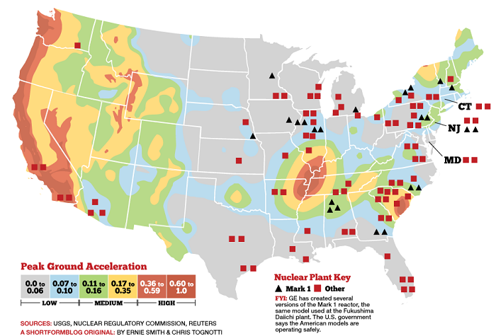
This map features the US nuclear reactors and the major US fault lines.
In other words, this map shows where earthquakes could result in nuclear nukes in the US.
A lot of tumult has been taking place here in America over the nuclear crisis unfolding in Japan. And, I bet that sometimes you are wondering about the earthquake-related nuclear devastation the US could face in case of an earthquake having the magnitude of the 2011 Japan quake which lead to the almost complete disruption of the Fukushima Daiichi nuclear plant.
This map presents the position of the US nuclear reactors (Reuters and NRC) superimposed on a map of the earthquake risk as measured by “Peak Ground Acceleration” (PGA) which matches with that of the US fault lines (USGS).
The map tells the tale:
- 23 US plants are presently using a Mark 1 (boiling water reactors) reactor, the same technology which was involved in the Fukushima Daiichi nuclear disaster in Japan. All are in the eastern half of the country (source).
- There are also eight nuclear power plants located along the seismically active West coast.
- Twelve of the American reactors that are of the same vintage as the Fukushima Daiichi plant are in seismically active areas.
The PGA risk is what is typically used to set building codes. Most nuclear power plants are designed to operate under 0.2g PGA, and automatically shut off if the PGA exceeds 0.2g. Remember this earthquake that shut down a nuclear plant on the US east coast! The following nuclear power plants have a two percent or greater chance of having PGA over 0.15g in the next 50 years: Diablo Canyon, Calif.; San Onofre, Calif.; Sequoyah, Tenn.; H.B. Robinson, SC.; Watts Bar, Tenn.; Virgil C. Summer, SC.; Vogtle, GA.; Indian Point, NY.; Oconee, SC.; and Seabrook, NH.


[…] Am I correct in saying we are on a major fault line. I just google fault lines and found this: US Nuclear Reactors vs Fault Line Map: This Map Shows Where Earthquakes Could Result in Nuclear Nuke… It looks like indy is pretty close to an edge. Snorko is a heck of a lot closer. I just heard 42 […]
[…] scheuren van vele centimeters. En waarom heeft men precies een voorliefde om kernreactoren te bouwenprecies op […]
[…] van vele centimeters. En waarom heeft men precies een voorliefde om kernreactoren te bouwen precies op breuklijnen!? Vergeet niet: deze mensen doen uitgebreid onderzoek voor het bouwen van deze […]
[…] http://www.npr.org/sections/alltechco… http://www.collapse.news/2016-05-20-i… https://strangesounds.org/2013/07/us-n… https://www.rt.com/news/339763-disast… https://www.thestreet.com/story/13684… […]
[…] https://strangesounds.org/2013/07/us-nuclear-reactors-vs-fault-line-map-this-map-shows-where-earthqua… […]
[…] This interactive map may save your life! In the extremely unlikely event of a meltdown, this great disaster response map from ESRI will tell you if you have to evacuate your home or not. This other map features the US nuclear plants and the US fault lines. […]
[…] US Nuclear Reactors vs Fault Line Map: This Map Shows Where Earthquakes Could Result in Nuclear Nuke… […]
[…] US Nuclear Reactors vs Fault Line Map: This Map Shows Where Earthquakes Could Result in Nuclear Nuke… (strangesounds.org) […]
[…] US Nuclear Reactors vs Fault Line Map: This Map Shows Where Earthquakes Could Result in Nuclear Nuke… (strangesounds.org) […]
[…] Sounds – US Nuclear Reactors vs Fault Lines < has 2 Louisiana NPPs on the […]