In 1861 an atmospheric river that brought storms for 43 days turned California’s Central Valley into an inland sea 300 miles long and 20 miles wide. Thousands of people died, 800,000 cattle drowned and the state went bankrupt. A similar disaster today would be much more devastating, because the region is much more populated and it is the single largest food producer in the U.S. Geologic core samples show that extreme floods like the one in 1861 have happened in California about every 200 years, since the year 200 A.D. So the next disaster could be coming around the bend. Like this week? There is indeed a strong area of low pressure that will move into the West Coast this week. And this system will tap into an atmospheric river, enhancing precipitation in central and southern California.
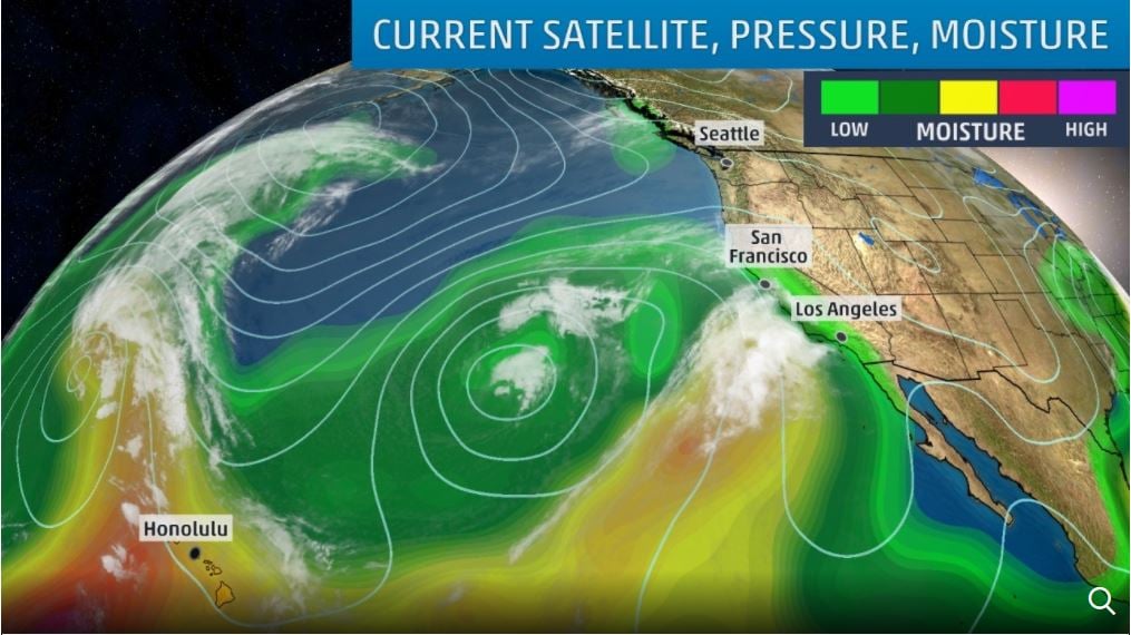
A strong low-pressure system tapping subtropical moisture will raise the risk of flooding and debris flows this week in Southern California while also spreading rain and heavy mountain snow across other parts of the West.
Mandatory Evacuation Order effective at noon tomorrow for all areas near Thomas, Sherpa and Whittier burn areas due to storm approaching . See full release at https://t.co/YL1BEtFQTM . #SantaBarbaraCounty #Carpinteria #Montecito #SantaBarbara #Goleta #SantaMaria pic.twitter.com/k7nDDkXiWL
— SB Sheriff's Office (@sbsheriff) March 20, 2018
The next system is currently in the northern Pacific Ocean and will slide southward and eastward early this week. In addition, this system will also likely tap into an atmospheric river, which is a thin, long plume of moisture that stretches from the tropics or subtropics into higher latitudes. In this case, subtropical moisture is expected to flow into portions of central and southern California.
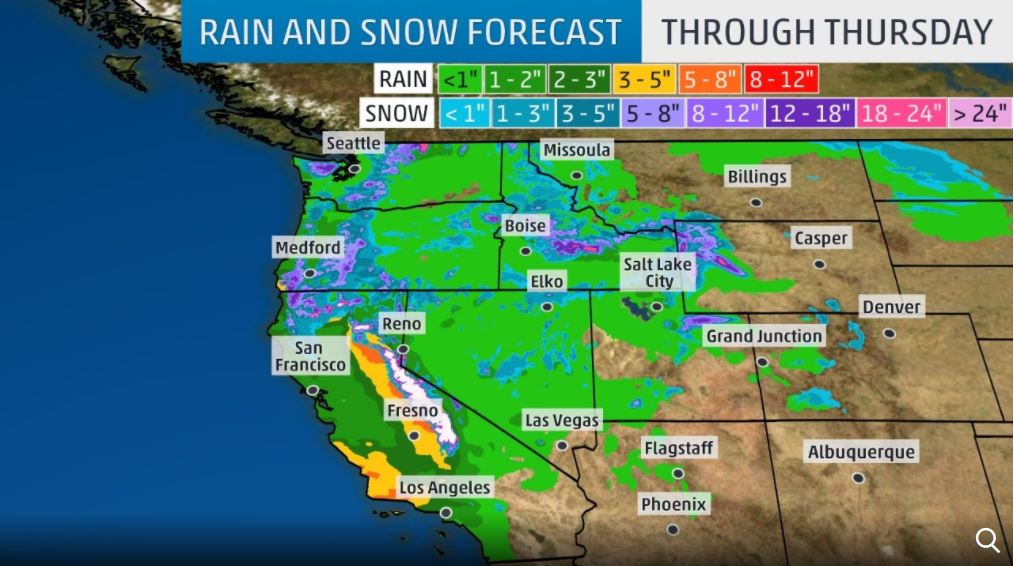
The National Weather Service (NWS) in Los Angeles noted in its Monday morning discussion this could be the “largest storm of the season” for the area.
Flash flood watches have been issued by the NWS in parts of Southern California and the southern foothills of the Sierra Nevada below 8,000 feet. Although rain will begin on Tuesday, the timing of the greatest concern for heavy rain is Wednesday-Thursday. Rainfall totals of 1 to 3 inches are expected for coastal and valley locations, with upwards of 3 to 6 inches (locally 10 inches) for the foothill areas.
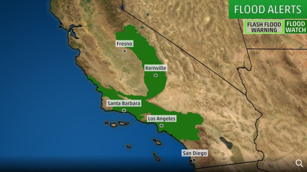
Rainfall rates could reach levels that increase the risk of mudslides and debris flows in Southern California. Of particular concern are the burn scars from the Thomas, Whittier, Creek, and La Tuna wildfires. There could also be flooding in urban areas and mudslides or rockslides in locations outside of the burn areas.
Serious flash flood/debris flow threat for recent burn areas w/ upcoming storm. Peak rainfall rates 0.50-0.75 inches per hour likely, with 20 percent chance up to 1.0 inch per hour. Flash Flood Watch posted. #CAstorm #LArain #cawx #Montecito #ThomasFire https://t.co/1x4KFGjL8f
— NWS Los Angeles (@NWSLosAngeles) March 20, 2018
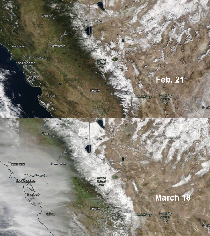
Meanwhile, heavy snow is expected in the Sierra Nevada during the second half of the week, where a recent series of storms has already dumped a record 16 feet of snow in March… Yes almost 1 foot / day! Winter storm watches have been issued by the NWS for the higher elevations where several feet of snow will pile up into Friday.
What is an atmospheric river?
An atmospheric river is a conveyor belt of vapor that extends thousands of miles from out at sea, carrying as much water as 15 Mississippi Rivers. It strikes as a series of storms that arrive for days or weeks on end. Each storm can dump inches of rain or feet of snow.
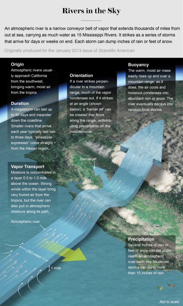
So Californians get ready for the storm of the year!


[…] An uncommonly intense April storm, dubbed Pineapple Express and powered by an atmospheric river, has pummeled northern California since Friday, prompting San Francisco officials to put up flood barriers, Yosemite to close campgrounds, the SF international airport to cancel more than 100 flights and Giants fans to lament that a game against the Los Angeles Dodgers has been postponed due to a rare AT&T Park rainout. This is the second atmospheric river in two weeks. Strange weather anomaly again! […]
[…] An uncommonly intense April storm, dubbed Pineapple Express and powered by an atmospheric river, has pummeled northern California since Friday, prompting San Francisco officials to put up flood barriers, Yosemite to close campgrounds, the SF international airport to cancel more than 100 flights and Giants fans to lament that a game against the Los Angeles Dodgers has been postponed due to a rare AT&T Park rainout. This is the second atmospheric river in two weeks. Strange weather anomaly again! […]
Ohhhh NO!!!! Don’t let CALIFORNIA DROWN!!!
Hopefully, the ATMOSPHERIC RIVER drains entirely into California… May be then MEXICO can give CALIFORNIAN’s “SAVE HAVEN’s” and “SANCTUARY CITIES”……
[…] In 1861 an atmospheric river that brought storms for 43 days turned California’s Central Valley into an inland sea 300 miles long and 20 miles wide. Thousands of people died, 800,000 cattle drowned and the state went bankrupt. A similar disaster today would be much more devastating, because the region is much more populated and it is the single largest food producer in the U.S. Geologic core samples show that extreme floods like the one in 1861 have happened in California about every 200 years, since the year 200 A.D. So the next disaster could be coming around the bend. Like this week? There is indeed a strong area of low pressure that will move into the West Coast this week. And this system will tap into an atmospheric river, enhancing precipitation in central and southern California. Read More… […]