The probability of a major earthquake occurring within the next 30 years has increased significantly in eastern Hokkaido, including Kushiro and Nemuro, according to a new seismic hazard map released by a Japanese Government committee.
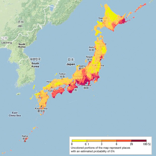
The 2018 national seismic hazard map indicates the danger of an earthquake measuring at least lower 6 on the Japanese seismic intensity scale of 7. A review of the scale and probability of a quake occurring in the Chishima Trench on the Pacific side of Hokkaido led to the indication of a higher danger level for eastern Hokkaido.
The probability for Kushiro in eastern Hokkaido rose 22 percentage points from the previous map to 69 per cent, while Nemuro saw its figure rise 15 points to 78 per cent. The increases are attributed to the scale and probability of an earthquake occurring in the Chishima Trench, which were revised last year.
By prefectural capitals, Chiba topped the list with 85 per cent as concerns have grown about a quake directly hitting the Tokyo metropolitan area. It was followed by Yokohama with 82 per cent and Mito with 81 per cent. The probability for Tokyo was 48 per cent, as the ground in areas near the Tokyo metropolitan government building is relatively firm.
Coastal areas saw seismic probabilities exceeding 80 per cent. Among focal areas along the Nankai Trough, the probability for Kochi rose one point from the previous map to 75 per cent. Shizuoka also rose one point to 70 per cent. Osaka, which was struck by a magnitude-6.1 quake registering a maximum of lower 6 on June 18, saw its probability remain the same as the previous map at 56 percent. The Earthquake Research Committee said Osaka is likely to continue facing a high probability.
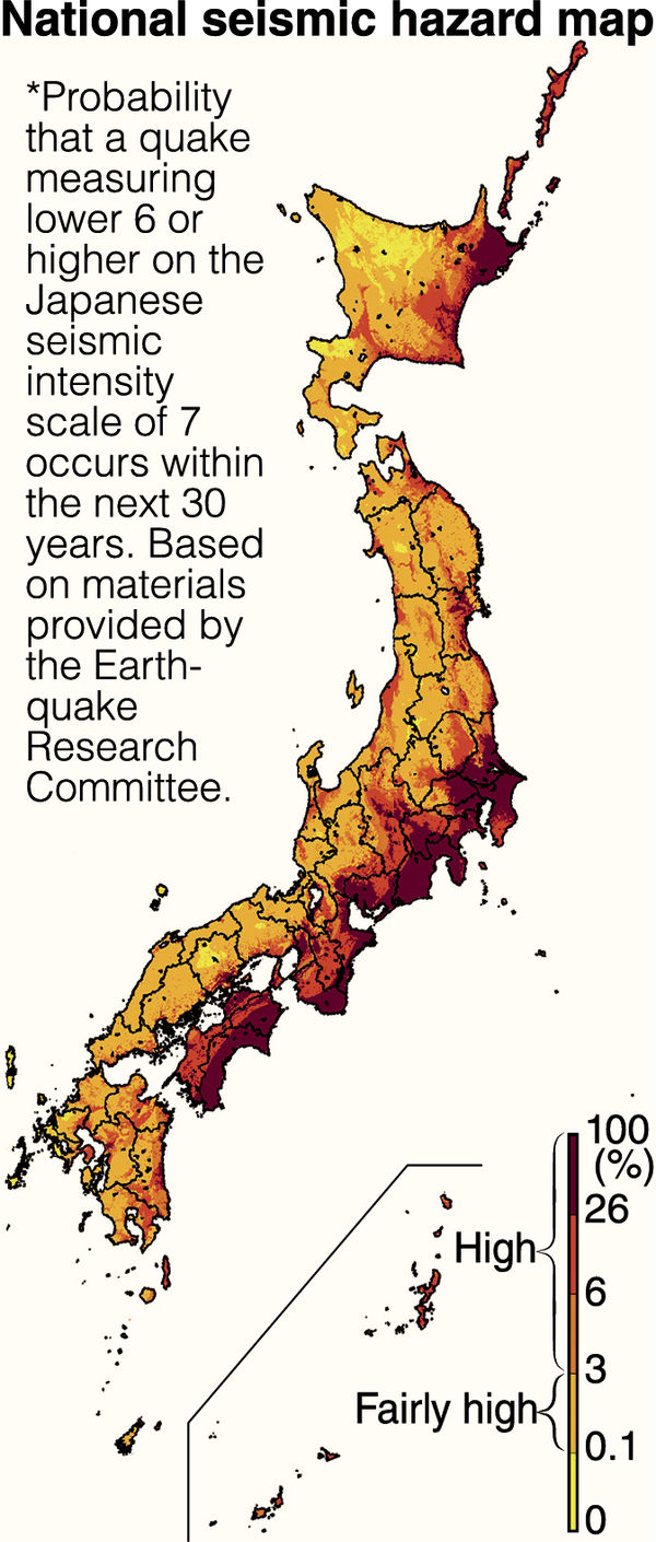
The government’s Earthquake Research Committee has released the map, which is based on data as of January 1 this year. Probabilities were estimated on the assumption that a magnitude-6-level quake could occur anywhere. The hazard map was created based on the history of earthquakes that have occurred on plate boundaries, such as the Nankai Trough on the Pacific side, as well as on major active fault zones and within plates. A quake measuring lower 6 is viewed as a yardstick for destroying structures such as wooden houses with low quake resistance and concrete block walls.


Mormons Exposed Reptilians.wmv
https://www.youtube.com/watch?v=eCoWCd7xZoc
“Mormons have been mistaken for polygamy. Really are a reptilian clone colony.”
Fire in Polygamous group’s ranch in Utah
Firefighters gain on blaze burning on polygamous group’s ranch; fires grow in southern Utah
https://www.sltrib.com/news/polygamy/2018/06/29/firefighters-gain-blaze/
“There’s one wildfire in Utah burning entirely on private land.
It’s the Rough Canyon Fire in Box Elder County. It’s burning on the Washakie ranch owned by the polygamous Kingston Group between the towns of Plymouth and Portage.”
http://www.popflock.com/learn?s=Kingston_clan
The Latter Day Church of Christ is a Mormon fundamentalist denomination in the Latter Day Saint movement. Also known as the Kingston Clan or the Kingston Group, it is a part of The Order, or the Davis County Cooperative, and The Co-op Society. There are approximately 3,500 members of this group.
Polygamist Mafia: Escaping The Kingston Clan
https://www.youtube.com/watch?v=GwoO7Nekmpw
God does not like all the religion that take away people’s freedom, choice, and right. Especially Mormon is created by Draco reptilians (Doraconians). All the religions should be disappeared from this Earth.
Today’s seismographs in the world. Find the active earth movement places.
https://earthquake.usgs.gov/monitoring/operations/heliplot.php
Alert: Hawaii Kilauea crater EXPANDING – Lava flow continues (Live Update)
https://www.youtube.com/watch?v=_uddbJPeBvQ
Raw: Colorado Wildfire Burns Six Square Miles
https://www.youtube.com/watch?v=fdag-hU1x3k
Spring Fire continues to grow, Highway 160 closed at La Veta Pass
https://www.youtube.com/watch?v=vPmUAGQyLbc
Look at the lady with strange skin discoloration at 2:16 on this video. This skin discoloration with greenish color mixed is the signature of a reptilian disguising as a human.
A huge mothership stopped by Pensacola, Florida.
Scary shelf cloud on Pensacola beach, Florida I 28.06.2018
https://www.youtube.com/watch?v=mul567_8bkA&list=UU1S3z1wG55b94sfw1XCtSww
SCARY TORNADO SIRENS GOING OFF IN ST.LOUIS, MISSOURI | June 28, 2018
https://www.youtube.com/watch?v=1dmWXusGo08&index=1&list=UUXqiR3oMm0MlT06ms1o6z5A
Severe Tornado in North Dakota, Williams – June 28, 2018
https://www.youtube.com/watch?v=FHLKBJzMIRA&index=1&list=UUIBieTlkO6RIwi6UMW6ik5w
he missing boys and coach entered the Tham Luang Nang Non cave in Chiang Rai province after a soccer game on Saturday afternoon. The cave complex extends several kilometers (miles) with narrow passageways and uneven ground and is known to flood severely in the rainy season.
http://www.newser.com/article/0e350eaaf4034664826a30d3bef36c35/thai-rescuers-search-for-other-entrances-to-flooded-cave.html
Look at all the images on this site. Why so many US military people are involving on this search? This cave system might be a part of the US reptilian secret underground bases in Thailand.
Actor Terry Crews EXPOSES Hollywoods DIRTIEST secrete to Congress
https://www.youtube.com/watch?v=Ej5AQBfNKd0
6 28 18 Destin, Florida Tornado Causes damage Along Beach
https://www.youtube.com/watch?v=374GeYbuWEs&list=UU1nJElGcVcTpeZJVyxEbzJw&index=6
Tornado in Japan
https://www.youtube.com/watch?v=-nWUC7eQ3cM&list=UUGCZAYq5Xxojl_tSXcVJhiQ&index=11
13 Satanist’s (=Reptilians) houses were burnt down just this month in Youngstown Ohio.
Youngstown firefighters concerned about recent spike in arson cases citywide
https://www.youtube.com/watch?v=0PkZ8Wwx70o
1 Dead, 12 Injured In Explosion, Partial Collapse At Gatesville Hospital Near Waco
https://www.youtube.com/watch?v=-9fOcm84L1w
“The explosion happened where the construction area for the hospital expansion.”
The hospital expansion = The Reptilian secret underground base expansion
The cause of explosion = The cleaning up operation by Galactic Federation of Light
END TIMES SIGNS LATEST EVENTS AND GOD’S WARNING (JUN 29, 2018) THIS HAPPENED ON OUR EARTH
https://www.youtube.com/watch?v=oF9bWPRBuo8
Heavy flooding and landslides in Lai Chau, Vietnam 24- 27 June 2018
https://www.youtube.com/watch?v=d6tGkUcckUs&index=1&list=UU2vfhm1DVuJz_TIIxN-_oOg
[…] and the probability of a quake occurring in the Chishima Trench on the Pacific side of Hokkaido led to the indication of a higher danger level for eastern Hokkaido. The probability for Kushiro in eastern Hokkaido rose 22 percentage points from the previous map to 69 percent, while Nemuro saw its figure rise 15 points to 78 percent. The increases are attributed to the scale and probability of an earthquake occurring in the Chishima Trench, which was revised last year. READ MORE […]