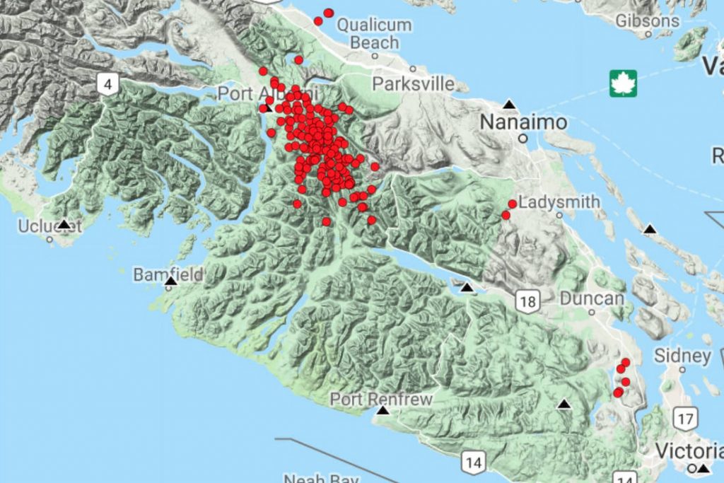
More than 150 tremors have hit Vancouver Island in the last 24 hours, and seismologists are monitoring the situation to see if it turns into an Episodic Tremor and Slip event. These events add pressure to the locked Cascadia Subduction Zone fault.

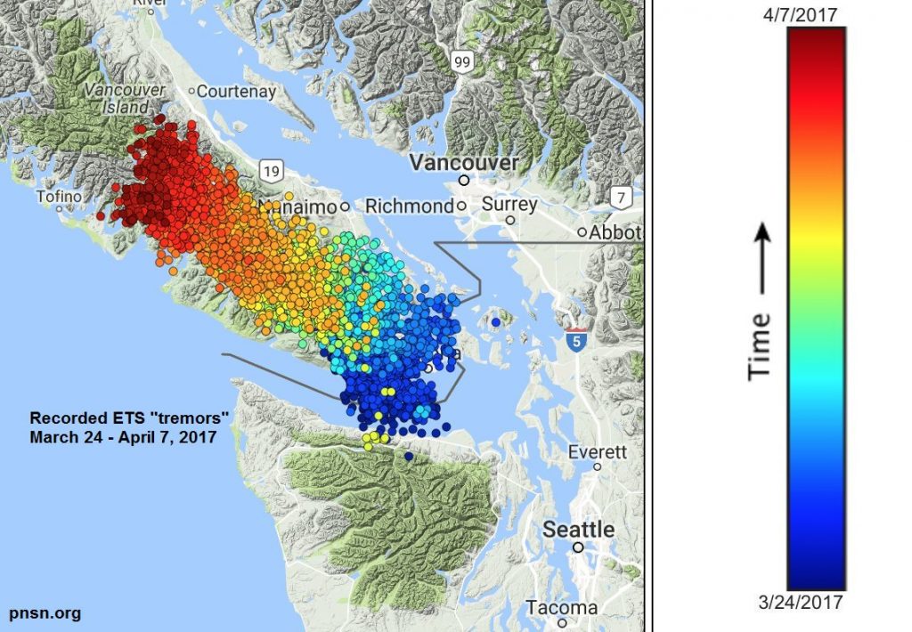
Vancouver Island is normally moving toward the Lower Mainland at a rate of about one centimetre per year. But every 14 months or so there is a Tremor and Slip event, when Vancouver Island slips backwards a few millimetres towards Japan. Seismic recording instruments show Victoria moving in one direction and then changing direction for about two weeks during these episodes. These events add pressure to the locked Cascadia Subduction Zone fault.
“It involves tiny tremors that we can record. They are not earthquakes. People don’t feel these shaking events. But we can easily record them over many seismic stations at the same time,” said Cassidy. “It looks like a train or a rumbling.”
You can see the energy building up slowly and then dropping off slowly, says Cassidy. It’s not a typical earthquake signature. It’s more of a rumbling vibration sort of signal.
The tremors are recorded and mapped out, to show where the slip is taking place. It helps to identify the locked portion of the subduction fault where all the energy is being stored for future earthquakes.
“This is a really important piece of information to help us understand the subduction zone where these big earthquakes are more likely to occur,” said Cassidy. “It doesn’t help us predict when an earthquake will occur, though.”

Due to the fact that Episodic Tremor and Slip events give a slight nudge to a locked fault, it is a period of slightly higher hazard but Cassidy assures that it is not a huge change.
“It is similar to driving in slightly heavier traffic than you normally would. There might be slightly more risk,” said Cassidy. “Bottom line is that we live in a subduction zone where earthquakes can happen at any time. These tremors are a reminder to us that we do live in an active zone and to be prepared.”
So now the big question is where this energy will be stored on the major and destructive Cascadia Fault zone!


[…] is currently a swarm of quakes on Vancouver Island, Canada. And the island sits just next to the Cascadia fault zone. Is this series of hundreds of quakes […]
Warning !!! Fast-moving river of lava flows from Hawaii’s Kilauea volcano
https://www.youtube.com/watch?v=rJ-dUq3SXWc
Today’s seismographs all over the world have very active movement. Today is the Summer Solstice that we are going to have more higher frequency (=vibration) on the Earth. More energy is coming into the Earth from outer space and Sun movement. This energy might be the reason that we have more active vibrations on the Earth.
https://earthquake.usgs.gov/monitoring/operations/heliplot.php
RAW: Epic hail and tornadoes slam Colorado’s front range
https://www.youtube.com/watch?v=K9bB2K0r8go
After the huge floods stroke many parts of the US including the cities of Texas at Mexican boarder, Trump finally changed his mind to end Mexican family separation. He signed this executive order on Wednesday morning.
Trump signs executive order to end family separation
https://www.rt.com/usa/430350-trump-signs-immigration-order/
“US President Donald Trump signed an executive order ending the practice of separating children from their families in detention centers for illegal immigrants. The order will likely be challenged in court, however.”
Flooding Breaks Dam in Wisconsin
https://www.youtube.com/watch?v=8H_Ez9smUKY
There are so many floods all over the world everyday! You cannot see those information very much on your TV news. They do not want you to know something is going on, and the Earth is changing.
State Of Emergency – NW Wisconsin
https://www.youtube.com/watch?v=A8qbcFlrBeE
New Brunswick flooding pinned on deforestation
https://www.youtube.com/watch?v=2fEWf5oGoGQ
Even I live in north Alabama, I see many logging trucks passing highway 247. Some places are completely deforested in the Wildlife Management Area. Who is managing and own the Wildlife Management Area? What is the purpose of the Wildlife Management Area? It is really suspicious. Wildlife = Reptilian life = Reptilian Underground Base?
Aerial video of flooding along the Sun River
https://www.youtube.com/watch?v=s5vhF-sIhrA
States Of Emergency Declared After Severe Flooding In Allegheny County
https://www.youtube.com/watch?v=qJ7eR9nN5FA
06-20-2018 Bethel Park, PA – Flash flooding sweeps cars away
https://www.youtube.com/watch?v=D4UenCxXyBU
this happened on our earth june 1 – 15 2018 …!! story volcano gutemalal ,Kilauea,flood ,
https://www.youtube.com/watch?v=l1tSdL7O4lQ&list=UUVcbwAofetjiPquuLF2Zdxw&index=3
A terrible flood occurred in China this month. It looked like many people died. It starts after 20:00 on this video. Viewer discretion is advised for some disturbing contents (floating bodies).
[…] is currently a swarm of quakes on Vancouver Island, Canada. And the island sits just next to the Cascadia fault zone. Does this series of quakes is another […]
What Would Happen If You Replace All Drinks with Water?
https://www.youtube.com/watch?v=JsYNgHbhwaI
Mercedes Dome Deemed Unsafe, People Re-routed to Other RGV Shelters
https://www.youtube.com/watch?v=1dx_G_sz9GM
06-20-2018 Mercedes, TX Aerial views from drone of flooding with some flooding clips
https://www.youtube.com/watch?v=EtP33x5JQWI
Heavy rains brings flood to Texas, Mercedes – June 20, 2018
https://www.youtube.com/watch?v=KPBbhTRZoZs&index=4&list=UUIBieTlkO6RIwi6UMW6ik5w
Parts Of Texas Submerged After Heavy Rain Triggers Flash Floods | NBC Nightly News
https://www.youtube.com/watch?v=nxF-P6bvhbQ
“Experts say the long-term drought and sunbaked soil compounded the water’s impact as more than a foot of rain triggered flash floods from McAllen to Mercedes, Texas.”
You know? McAllen is the city with facilities with Mexican young people inside the cages.
CBP concentration camp at McAllen, Texas (June 17, 2018)
https://www.youtube.com/watch?v=LaHrXs1dkMU
This flood is obviously an attack from Galactic Federation of Light. Galactic Federation of Light does not like this Government giving Mexican young people to the organization of human trafficking. They might end up in the Human Meat factories and Blood Sacrifice for reptilians who needs human blood to keep their human figures.
RIO GRANDE VALLEY UNDERWATER
https://www.youtube.com/watch?v=I3dXdCR-Uko
Look at Intellicast radar right now! Click the Layers, then temperature. You can see -40 degree on the Gulf of Mexico near boarder between Louisiana and Texas. Around there, water temperature are 84 & 86 degree. Why the temperature is -40? Something is going on around there. I have never seen -40 on Gulf of Mexico where water temperature is quite high like hot springs.
Click the Layers, then temperature.
http://www.intellicast.com/Local/WxMap.aspx