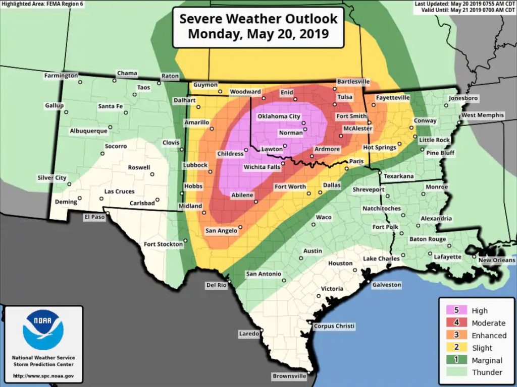
An outbreak of violent thunderstorms, including large, destructive tornadoes, is predicted in the Southern Plains through Monday night. “Particularly dangerous situation” tornado watches have been issued for western and central Oklahoma, including Oklahoma City, and the Texas Panhandle. The National Weather Service has issued an exceptionally rare “high risk” outlook for not only tornadoes, but also flash flooding in portions of central Oklahoma for the first time in 2 years.
Central and western Oklahoma are now under a “particularly dangerous situation” tornado watch, until 10 p.m. central, joining the Texas Panhandle. This kind of watch is reserved for the most serious severe weather situations. The watch includes Oklahoma City and Norman.
A tornado watch has been issued for parts of Oklahoma and Texas until 10 PM CDT pic.twitter.com/yBp5Jmhrm3
— NWS Tornado (@NWStornado) May 20, 2019
The National Weather Service Storm Prediction Center, which issued the watch, warned “numerous tornadoes and several intense tornadoes expected” in addition to straight line wind gusts to 80 mph, and large hail up to the size of softballs.
It indicated a greater than 95 percent chance (or near certainty) of:
- At least two tornadoes and one or more strong tornadoes (rated EF2 or higher)
- 10 or more cases of severe straight-line winds (of at least 58 mph) and at least one case of 75 mph straight-line winds
- 10 or more cases of severe hail (at least one inch in diameter) and at least one case of hail larger than two inches in diameter
It tweeted that this is only the second time in its history it has issued a watch with such high likelihoods.
PDS Tornado Watch # 199 is coming for Oklahoma. This is only the second watch in SPC history where every category of watch probabilities (torn, wind, hail) are at greater than 95%.
— NWS SPC (@NWSSPC) May 20, 2019
The only other watch like this was issued for Alabama on 27 April 2011. pic.twitter.com/BgpjKBMffL
In a discussion posted at 1:21 p.m. central, it wrote: “Environmental signals are continuing to point towards a tornado outbreak with multiple strong to potentially violent tornadoes across portions of western and central OK later this afternoon into the evening.”
The outlook added “tornadic potential appears very high” and that both model simulations and environmental conditions “point to a tornado outbreak developing later this afternoon featuring strong to violent long-track tornadoes.”
Think twice about chasing
Meteorologist Mike Smith, who has chased tornadoes since 1972, is sitting out today’s storm outbreak given its danger.
“I will not be out today. It is too dangerous,” he tweeted. “The tornadoes will be difficult to see and too dense & flooding could cut off escapes.”
To: #StormChasers
— Mike Smith (@USWeatherExpert) May 20, 2019
I believe I am the only one of the original, 1972, chasers still chasing. But, I will not be out today. It is too dangerous. The tornadoes will be difficult to see and too dense & flooding could cut off escapes.
PLS THINK TWICE ABOUT CHASING TODAY #wxtwitter
Meanwhile, hordes of storm chasers have congregated in the volatile zone:
— Shawn Milrad (@shawnmilrad) May 20, 2019
‘Particularly dangerous situation’ tornado watch posted for Texas Panhandle
Amarillo, Abilene, and Lubbock, Texas have been placed under a “particularly dangerous situation” tornado watch until 8 p.m. central. This type of watch is reserved for the most serious severe weather situations. The National Weather Service’s Storm Prediction warns that multiple tornadoes are expected in the watch area “with a few intense tornadoes likely.” It also projects large hail up to four inches across.

Overview from Monday morning
A dangerous severe weather outbreak is set to play out across the southern Plains Monday afternoon and night. Forecasters expect violent tornadoes, widespread flash flooding, and a barrage of hail and wind.
Western and central Oklahoma and parts of the Texas Panhandle are expected to be hardest hit. The National Weather Service Storm Prediction Center has warned of the potential for an outbreak of “long track and violent” tornadoes in this area, which includes Oklahoma City and Norman, Okla.
The Storm Prediction Center has placed these areas in a rare “high risk” zone for severe weather reserved for only the worst events, which are “long-lived, very widespread, and particularly intense.” Two million Americans are in this volatile zone. This is the first time the Storm Prediction Center has designated a “high risk” area since May 18, 2017.
“I have a feeling it’s going to be one of those outbreaks that we never forget,” tweeted Beth Carpenter, a meteorologist for TDS Weather, a consulting and forensics company.
Here we go. Prob Sig Tor tomorrow increasing to 75-90% across northern Texas and most of Oklahoma tomorrow afternoon and evening. Extremely high. I have a feeling it’s going to be one of those outbreaks that we never forget. #OKwx #TXwx #KSwx #severewx #tornadoes pic.twitter.com/QtdUv3Cw72
— Beth Carpenter | TDS Weather (@B_Carp01) May 20, 2019
“This is the rare kind of event that may take many lives,” added Roger Edwards, an atmospheric scientist, longtime storm chaser and weather historian. “Pray I’m wrong.”
Leaving shift this morning, scientific prediction done, a sobering, brutally honest realization hits: even if outlooks, watches & warnings are great, that doesn’t stop the #tornado swarm & destruction. This is the rare kind of event that may take many lives. Pray I’m wrong.
— Roger Edwards (@SkyPixWeather) May 20, 2019
The strength of the weather system predicted to trigger these storms is record-challenging, both near the ground and at high altitudes.
Storms will come in multiple waves, with repeated rounds lasting through much of Monday night.
Strength of upper-level system and surface low over Plains by Tuesday among strongest on record for this time of year. Major contributor for #severe and flash #flood outbreak. (Graphics via @burgwx) pic.twitter.com/pro9TEL7cE
— Jonathan Erdman (@wxjerdman) May 20, 2019
The first batch pushed through early Monday morning, heralded by several clusters of quickly-moving storms warned for three inch-diameter hail and torrential rainfall.
NEW Severe Thunderstorm WARNING issued for parts of Beaver (OK), Lipscomb, Roberts, Hemphill & Ochiltree counties until 7:45AM. This system is tracking east at 35mph. Threats include three inch hail and 60mph wind gusts. #txwx #phwx #okwx pic.twitter.com/GAk1VndxRL
— Delaney Wearden (@DelaneyWearden7) May 20, 2019
“We’re underway with watches and warnings in what will be a non-stop 24 to 36 hour onslaught of severe storms, flooding and tornadoes,” tweeted Rick Smith, warning coordination meteorologist at the National Weather Service forecast office in Norman.
8AM – we're underway with watches and warnings in what will be a non-stop 24 to 36 hour onslaught of severe storms, flooding and tornadoes. Many of us will get multiple rounds of severe weather, and flooding will be disastrous for some. Stay alert and be ready for anything. #okwx pic.twitter.com/dP6Tdl62tE
— Rick Smith (@ounwcm) May 20, 2019
The atmosphere was predicted to turn even more conducive for storms in the afternoon and evening. It will be marked by “extreme instability” according to the Storm Prediction Center, allowing for “rapid supercell formation … [and] a significant threat to life and property.”
A swarm of supercells, the most intense thunderstorms that spin and can spawn tornadoes, are forecast to erupt just west and perhaps a little south of the Oklahoma/Texas border and well east of Interstate 27, tracking northeast at a breakneck 40 to 50 mph pace.
“I’d certainly label this ‘the nightmare scenario’,” tweeted Mike Smith, a meteorologist with decades of experience monitoring Midwest storms.
I’d certainly label this “the nightmare scenario." pic.twitter.com/Ut4zzP5KPx
— Mike Smith (@USWeatherExpert) May 20, 2019
Additional rotating storms are predicted to form in southwest and south central Oklahoma south of Interstate 40 and west of Interstate 35 during this time. The Oklahoma City Metro area could be impacted as storms ride up the H.E. Bailey turnpike early Monday evening.
In an environment like this, conditions can change fast, and storms will evolve rapidly. With the abnormally high amount of wind shear — rotational energy — present in the atmosphere, any storm that fires will begin to rotate.
Tornado probabilities are “off the charts,” tweeted Sam Lillo, a PhD student in meteorology at the University of Oklahoma.
SREF-calibrated tornado probabilities for tomorrow.
— Sam Lillo (@splillo) May 20, 2019
Off the charts. pic.twitter.com/jomuCrFtm7
The Storm Prediction Center wrote that the combination of instability and atmospheric spin will likely yield “multiple significant” tornadoes, rated EF2 or higher on the 0 to 5 scale for twister intensity.
In addition to tornadoes, very large hail exceeding the size of softballs and straight-line winds topping 80 mph are possible in the strongest supercells.
With every thunderstorm yielding a risk for eventual tornadoes, forecasters urged residents to stay abreast of up-to-date weather warnings as they’re issued, especially true during the overnight, when tornadoes are likely to continue.
“Have a safety plan, stay calm, and keep up to date with the latest weather information from a trusted source,” the National Weather Service forecast office serving Norman tweeted.
Significant severe weather is expected Monday and Monday night. Being informed on the potential is a big part of staying safe. Have a safety plan, stay calm, and keep up to date with the latest weather information from a trusted source. #okwx #texomawx pic.twitter.com/VALx4NLu8k
— NWS Norman (@NWSNorman) May 19, 2019
As bad as the tornadoes might get, flooding could be equally dangerous.
The Weather Prediction Center — the branch of the National Weather Service that handles precipitation concerns — has also hoisted a high risk for excessive rainfall.
Its forecast warns that “numerous, potentially significant flash flood events are likely,” the greatest odds in the Oklahoma City to Tulsa corridor northward. That’s where storms will merge and eventually stall Monday night, bringing with them a fire hose of moisture.
Definitely a dual threat day with the potential for tornadoes and dangerous flooding. Parts of our area are in both a high risk for severe weather and a high risk of flooding. Please stay alert and stay safe today and tonight! #okwx #txwx pic.twitter.com/weJbEFTIWb
— NWS Norman (@NWSNorman) May 20, 2019
Flash flood watches blanket most of Oklahoma and adjacent northwest Arkansas. A widespread four to six inches with localized eight-to-10-inch amounts will fall just north of a stationary front, which will be draped along Interstate 40 and Interstate 44 during the overnight. The storms will last through daybreak Tuesday morning, finally clearing from west to east during the day.

Many of these same areas have already seen 200 to 300 percent their “normal” rainfall over the last two weeks, the sodden ground unable to handle much more water. And while predicted to meander just north of the city, if the band of heavy rain crashes south toward the Oklahoma City metro area, the results could be disastrous.
Coincident with the deadly May 31, 2013 tornado in El Reno, Okla., which killed eight people, 13 lives were lost in flash flooding in Oklahoma City.
Monday’s bout of life-threatening weather comes on an already infamous day — May 20. In 2013, this date was marked by an EF-5 tornado that ravaged Moore, Okla. It claimed 24 lives and leveled much of the same community that was slammed by an F5 in 1999. And six years since their last tornado disaster, the community is at risk again.
The city of 60,000 isn’t taking any chances, joining hundreds of other school districts across the Sooner State to shut their doors Monday.
MPS will be closed tomorrow – Monday, May 20, 2019. Please be weather aware. @MooreHS1 @WestmooreHS @SouthmooreHS pic.twitter.com/csYHqIRn3Z
— Moore Public Schools (@MoorePublicSch) May 19, 2019
The University of Oklahoma has canceled classes Monday as well, offering students and faculty a list of storm shelters.
This is terrifying. Just be very very safe!
Follow us on FACEBOOK and TWITTER. Share your thoughts in our DISCUSSION FORUMS. Donate through Paypal. Please and thank you
[TWP]


