Forest fires can reach 2,000 Fahrenheit. That’s about 1/5 the temperature of the surface of the sun.
But what is the impact of such high temperatures on the soil and plants of our forests? To answer these questions, USDA Forest Service decided to study a prescribed fire from start to finish. And the sound of the forest fire is just eerie:
[adthrive-in-post-video-player video-id=”ncnEriYD” upload-date=”2019-08-22T13:17:03.000Z” name=”The terrifying sound of raging wildfires” description=”The terrifying sound of raging wildfires”]Answering questions about the impact and consequences of wildfires on the soil and plants of our forests and how do the intensity and heat of a wildfire impact its behavior, smoke and the surrounding weather is difficult since it is hard to predict when and where fires will occur.
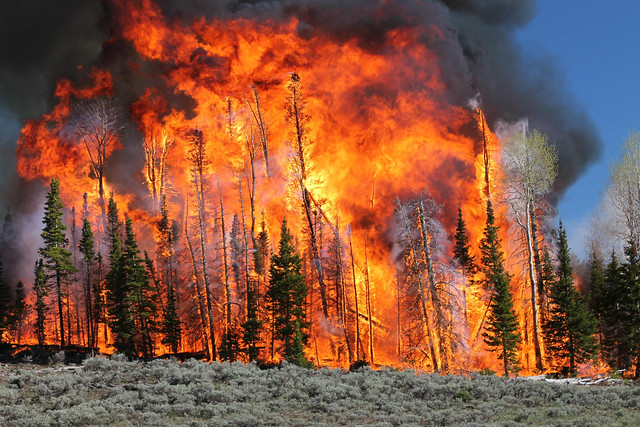
So a team of scientists from USDA Forest Service and the interagency Fire and Smoke Model Evaluation Experiment, or FASMEE set 2,000 acres of the Fishlake National Forest in Utah on fire this past June and studied its development from the beginning ot its end.
As reported by USDA:
After months of planning and preparation, Fishlake National Forest fire crews ignited more than 2,000 acres of Utah forest in an effort to consume living upper canopy vegetation and initiate growth of new vegetation. This June 2019 prescribed fire was designed to restore aspen ecosystems by removing conifer trees and stimulating the regrowth of aspen.
Researchers at the Pacific Northwest Research Station and Rocky Mountain Research Station, as well as other FASMEE participants, saw the fire as a unique opportunity for study. Prior to the fire, Forest Service research experts took measurements of the forest vegetation and fuel loads. They also set up special fire-proof equipment to record and measure the heat of the fire throughout the project. Embedded below is a video recorded during the burn.
Fishlake National Forest Manning Creek burn sensor from Forest Service on Vimeo.
During the fire, scientists used LiDAR, radar, aircraft and satellite imagery, weather and atmospheric measurements, and ground monitoring to study the fuel (dead materials) consumed, fire behavior and the fire’s impact on living vegetation. Scientists will continue to monitor the area to determine how vegetation recovers after fire.
Building upon this success, experts are planning a similar project for later this fall to continue studying and learning about fire.
The data is invaluable to predict fire behavior, smoke impacts and the short- and long-term effects of extreme fires.
Read More:


