A fault near Portland, Oregon, has the capacity to cause strong shaking in the region — and has done so as recently as 1,000 years ago.
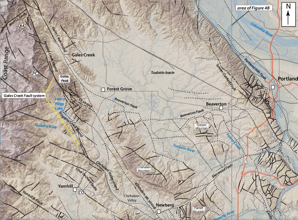
New research into the Gales Creek fault, which lies 22 miles (35 kilometers) west of Portland, reveals that earthquakes on the fault have ruptured the surface three times in the last 9,000 years.
Today, the fault is capable of producing an earthquake of up to magnitude 7.1 to 7.4, which would create very strong shaking and damage property and potentially threaten lives in the Portland metro region.
Rare big quakes
Fortunately, big quakes on the fault are rare, researchers reported Oct. 20 and recur every 4,000 years or so, as a rough average, and there is no evidence that the fault is currently at high risk of rupture.
However, the new findings suggest the need to study other nearby faults for signs of relatively recent earthquakes. These investigations could reveal more about the dangers these faults pose to Portland and other populated areas in Oregon.
“Many faults in the region are of interest based on their proximity to population centers,” said Alison Horst, a paleoseismologist formerly at Portland State University and now at the Washington State Department of Resources.
Gales Creek
Portland is in the Cascadia Subduction Zone, the region of the Pacific Northwest where the Juan de Fuca tectonic plate is diving beneath the North American plate. This subduction of the plates gives rise to earthquakes and volcanic activity.
Gales Creek is considered a forearc fault, which means it is located in the region between the spot where the plates meet and the volcanic chain link to the subduction zone.
It runs 45 miles (73 km) in a northwesterly direction in a lush, forested area of the Coast Range mountains north of the Willamette River. The vegetation makes it difficult to see evidence of past earthquakes on the fault, such as the cliff-like scarps that form when Earth’s crust breaks.
However, mapping efforts using a technology called lidar (light detection and ranging) suggested that the fault showed the fingerprints of past quakes. For example, the paths of some streams along the fault were offset, as if they’d been suddenly shifted to one side.
Ancient earthquakes on the Gales Creek Fault
To trace the history of the Gales Creek fault, Horst and her colleagues dug a set of trenches up to 4.9 feet (1.5 meters) deep, using shovels and a backhoe. Within these trenches, they could see layers of sediment deposited over many thousands of years, including streaks of dark, charcoal-rich soil left behind by long-ago floods. Broken parts of these layers showed evidence of past earthquakes.
Because the charcoal is organic material, the researchers could use radiocarbon dating, which relies on the decay rate of radioactive forms of carbon, to pinpoint when the layers had been put down.
This geological history showed three earthquakes large enough to disturb the Earth’s surface on the fault. The oldest dated back about 8,800 years ago, the next 4,200 years ago, and the most recent approximately 1,000 years ago. This averaged out to a significant earthquake approximately every 4,000 years on the Gales Creek fault.
Given the length of the fault, the researchers calculated that if the entire Gales Creek fault were to slip today, it could create an earthquake of between magnitude 7.1 and magnitude 7.4, depending on the depth of the earthquake’s origin.
The actual risk of the entire fault rupturing in the near future is unknown, though.
The most recent earthquake along a similar fault in the region was a magnitude-5.7 quake in March 1993 just south of Portland, which caused $30 million in damage, the authors wrote.
The next step is to study other faults in the regions for signs of ancient earthquakes. Learning when other faults cracked could reveal connections between faults, which would further clarify the earthquake hazards around Portland.
This article about the dangerous Gales Creek Fault near Portland was originally published on Live Science. More earthquake and fault line news on Strange Sounds and Steve Quayle.


Is that first illustration purposely confusing? WHICH WAY IS NORTH AND WHICH WAY IS SOUTH? And how about a wider view of where it is in the state!
right! I just added a new map of the region. I hope it helps you! Best and thank you
It is stupid remian in big cities, and cities will be center of storms that mankind never been see before. Unfortunatley those who choose to stay in the same cties large and no way out will see a lot of it. Still little time is left move out of big cities now.
Thus providing a real solution to the secession of idiot liberal portions
of states, i.e. complete destruction.